Download
1 / 1
10 likes | 162 Vues
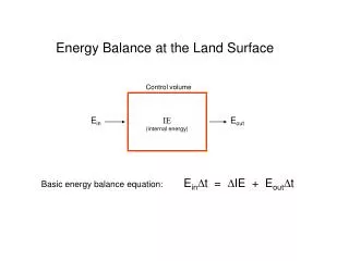
Joint assimilation of in-situ and remotely sensed surface soil moisture and LAI observations in a simplified variational scheme J.Mu ñoz Sabater (1) , J-C. Calvet (1) , L. Jarlan (2) (1) CNRM Meteo-France, (2) ECMWF. . . (1). y. y. (p). t=0 1 2 … p.

E N D
Joint assimilation of in-situ and remotely sensed surface soil moisture and LAI observations in a simplified variational scheme J.Muñoz Sabater (1), J-C. Calvet (1) , L. Jarlan (2) (1) CNRM Meteo-France, (2) ECMWF (1) y y (p) t=0 1 2 … p Joint assimilation of in-situ and remotely sensed surface soil moisture and LAI observations in a simplified variational scheme J.Muñoz Sabater (1), J-C. Calvet (1) , L. Jarlan (2) (1) CNRM Meteo-France, (2) ECMWF Joint assimilation of surface soil moisture and LAI observations with a simplified 1D-VAR assimilation scheme J. Muñoz Sabater (1), C. Rüdiger (2) , J.-C. Calvet (2), L. Jarlan (3), S. Massart (1) (1) CERFACS, Toulouse, France (2) CNRM, Meteo-France, Toulouse (3) CESBIO, Toulouse, France MOTIVATION METHODOLOGY RESULTS - II • Why Land Surface Models are needed? • They provide an explanation of surface processes • Their estimations are used for meteorologist and climatologist as lower boundary conditions for NWP models. • Provide an estimation of the surface variables (Temperature, moisture, vegetation volume, etc.) Why assimilate observations of the surface soil moisture and LAI? • They can be estimated from remote sensing observations, at local scale and relative good temporal-spatial resolutions. • Physically related to key surface variables: the root-zone soil moisture and the vegetation biomass. • Potential improvement of the up-welling water and energy fluxes, as input for NWP models. • Why Land Surface Models (LSM) are needed? • LSM simulate the temporal and spatial evolution of surface variables (temperature, soil moisture, biomass, etc.). • Such predictions are required in meteorology and climatology as lower boundary conditions for NWP and GCMs. Why to assimilate observations of surface soil moisture and LAI? • These observations are physically related to key surface variables, such as root-zone soil moisture (w2) and vegetation biomass. • They have the potential to be retrieved at a global scale through remote sensing at adequate temporal and spatial resolutions. • The assimilation can improve the up-welling water and energy fluxes, as input for NWP models. ASSIMILATION APPROACH: Based on the results of Muñoz Sabater et al. (2007a), the Simplified 1D-VAR (Balsamo et al., 2004) method was applied. The LSM was reinitialized by optimally combining the information provided by observations and the LSM. The Simplified 1D-VAR minimizes the cost function J: [1] Linear Tangent Hypothesis: Linearization of the non- linear observation operator H by perturbation of the initial value of the state variables (w2 and vegetation biomass). Under the linear tangent hypothesis (where H is assumed to be linear) and with errors (background B and observations R matrices) following a normal distribution, it is not necessary to derive an adjoint or linear tangent model to compute the minimum of J. The equations to update the state of the system for the two state variables (w2 and vegetation biomass) are: [2] The data set was assimilated into the ISBA-A-gs LSM (Calvet et al., 1998) using the simplified 1D-VAR scheme. The assimilation window length was of 10 days, where 1 LAI and 4 wgobservations were available. 11111111111111111111111111111111111111111111111111111111111111111111111111111 22222222222222222222222222222222222222222222222222222222222222222222222222222 3333333333333333333333333333333333333333333333333 444444444444444444444444444444444444444444444444444 5555555555555555555555555555555555555555555555555 6666666666666666666666666666666666666666666666666 77777777777777777777777777777777777777777777777777 888888888888888888888888888888888888888888888888 AAAAAAAAAAAAAAAAAAAAAAAAAAAAAAAAAAAAAVBBBBBBBBBBBBBBBBBBBBBBBBBBBBBBBBBBBCCCCCCCCCCCCCCCCCCCCCCCCCCCCCCCCCCDDDDDDDDDDDDDDDDDDDDDDDDDDDDDD x: state variable xb: background or first guess y: vector of observations H: observation operator B, R: background and observation error covariance matrices y(i) = yT (i) – yT’(i) y (observed Variable) A: w2nit Fig 5.- Joint assimilation of in-situ LAI and wg observations. The temporal assimilation window is of 10 days OBJECTIVES A B: w’2nit= w2nit + w2init B T’ Fig 3.- Same as in fig. 2, but with precipitation set to zero. This test was undertaken in order to study the response of the assimilation scheme to strong errors in the atmospheric forcing. • Joint assimilation of remotely sensed LAI and surface soil moisture observations (wg) in a simplifiedvariational method. • Update of the root-zone soil moisture and the vegetation biomass. • Study of the impact of a joint assimilation of observed LAI and surface soil moisture on the retrieved variables. A: Bioinit T A B: Bio’init= Bioinit + Bioinit B CONCLUSIONS Fig.2- Schematic figure of the linearization of the observation operator H • In general, good w2 analysis. However the vegetation biomass needs to be improved. • Evidence of the need to determine improved observational and model state errors as a function of time. • Further,our study demonstrated that the analysis of the wilting point could be necessary during dry periods for one-layer surface models (Muñoz Sabater et al., 2007b). • The analyses are degraded if an atmospheric forcing of less quality is introduced (for instance, without information about precipitation), but the assimilation still provides valuable information about the state variables. • Potential use of the simplified 1D-VAR to be implemented in a complete 2D operational configuration. Third InternationalWorkshop on Catchment-scale Hydrological Modeling and Data Assimilation, 9-11 Jan 2008, Melbourne, Australia EXPERIMENTAL SITE • SMOSREX(De Rosney; 2006): Field scale experience situated at the South-West of France (43º23’N, 1º17’E, 188 m altitude). • Manual and automated measurements: • Atmospheric forcing (downwelling short wave and long wave radiation, air temperature and specific humidity, precipitation, atmospheric pressure, wind speed, vapor pressure). • Soil temperature and soil moisture profiles. • Vegetation and soil parameters (LAI, canopy height,mesophyll conductance,sand and clay content, soil root depth, wilting point, field capacity, critical extractable soil moisture, etc.) • Multispectral radiometric measurements: • Brightness temperatures (TB) at L-band (1.4 GHz) over fallow and bare soil. • Reflectances over fallow at 450, 549, 648, 837 and 1640 nm. PERSPECTIVES RESULTS - I • Assimilation of the real remote sensing data provided by the radiometers of SMOSREX (Fig. 1). • Extension of the assimilation scheme to a complete 2D configuration at the South-West of France. • Integration of the air temperature and humidity observations within the complete 2D assimilation scheme. L-band radiometer BIBLIOGRAPHY • Balsamo G., Bouyssel F., and Noilhan J., 2004:A simplified bi-dimensional variational analysis of soil moisture from screen-level observations in a mesoscale numerical weather-prediction model. Q. J. R. Met. Soc., 130A, 895-915. • Calvet, J.C., Noilhan J., Roujean J.-L., Bessemoulin P., Cabelguenne M., Olioso A., Wigneron J.-P., 1998: An interactive vegetation SVAT model tested against data from six contrasting sites. Agric. For. Meteor., 92, 73-95. • De Rosnay, P.,and coauthors, 2006: SMOSREX: A long term field campaign experiment for soil moisture and land surface processes remote sensing. Remote Sens. Environ., 102, 377-389. • Muñoz Sabater, J., L. Jarlan, J.-C. Calvet, F. Bouyssel and P. De Rosnay, 2007a: From near surface to root zone soil moisture using different assimilation techniques. Journal of Hydromet., 8, 194-206. • Muñoz Sabater, J., C. Rüdiger, J.-C. Calvet, N.Fritz,L. Jarlanand Y. Kerr, 2007b: Joint assimilation of surface soil moisture and LAI observations in a Land Surface Model. Accepted for .Agric. For. Meteor. Table 1.-Global RMSE and mean bias (mb) for the root zone-soil moisture (in m3 m-3), the above-ground vegetation biomass (in kg m-2), and the LAI (in m2 m-2) between the analyses and the control simulation. The efficiency E (Nash criteria) is also indicated. Fig.1- Radiometers at SMOSREX Fig 2.- Joint assimilation of in-situ LAI and wg observations. The temporal assimilation window is of 10 days