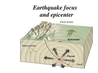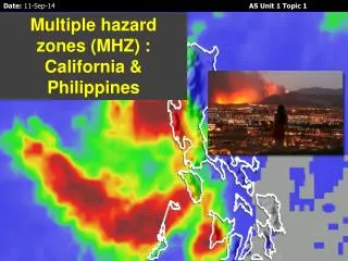
Earthquake Hazard Assessment Studies: temporal variability
170 likes | 341 Vues
Earthquake Hazard Assessment Studies: temporal variability. Dr. Ken Hudnut Chief, So. Calif. Earthquake Hazard Assessment Project Earthquake Hazards Team U. S. Geological Survey. Plenty of eq.’s to study and new data. Landers 1992 (including Joshua Tree and Big Bear) 1994 Northridge

Earthquake Hazard Assessment Studies: temporal variability
E N D
Presentation Transcript
Earthquake Hazard Assessment Studies:temporal variability Dr. Ken Hudnut Chief, So. Calif. Earthquake Hazard Assessment Project Earthquake Hazards Team U. S. Geological Survey
Plenty of eq.’s to study and new data • Landers 1992 (including Joshua Tree and Big Bear) • 1994 Northridge • 1999 Hector Mine • 250+ SCIGN stations • CMM3 available now • Total of over 60 publications using SCIGN data so far SESAC 6/11/03
SCIGN Data Products • 1st Year • Combined time • series (1996-2002) • 3rd Year • Real-time earth- • quake response • 5th Year • Resolve rates on • primary LA basin • faults (and others) SESAC 6/11/03
SCEC Tectonic Geodesy • 1st Year • Complete and • distribute CMM3 • 3rd Year • Integrate InSAR • with GPS for • vertical defor- • mation rates • 5th Year • Resolve rate dis- • crepancies • between geology • and geodesy SESAC 6/11/03
Los Angeles metropolitan region • Bawden et al., 2002 Nature paper • Seasonal variations in SCIGN data correlated with water table changes • Removal of this noise enabled a refined velocity map for the urban area SESAC 6/11/03
LA hazard - the SCEC way • Master model envisioned by Aki • Must integrate many types of information • Combine GPS with the deep fault geometry (from imaging and seismicity, etc.) and 3D structure • Employ novel modeling methods D. Argus, JPL SESAC 6/11/03
Improving hazard assessment • Temporal variations do occur: • Clustering (e.g., Basin & Range, ECSZ, Asia) • Discrepant geological and geodetic rates • Sequences involving fault interaction (e.g., Joshua Tree - Landers - Big Bear - Hector Mine; Anatolian system, etc.) • Implement robust research findings into hazard assessment Courtesy Anke Friedrich SESAC 6/11/03
Examples of differences in rate • Garlock fault • Geologic rate 7 +/- 2 mm/yr • Geodetic rate 2 +/- 2 mm/yr • Geodesy < Geology => weak lower crust • Eastern California Shear Zone • Geologic rate summed over all faults is ~6 mm/yr • Geodetic rate across ECSZ is ~10–12 mm/yr • Geodesy > Geology => clustering or new higher tectonic rate? • Imperial Valley • Geologic rate of 20 mm/yr • Geodetic rate across valley of ~50 mm/yr => missing a major fault? • Sierra Madre – Cucamonga fault zone • Geologic rate of 0.5 mm/yr • Geodetic rate of a • Raymond fault • Geologic rate of 1.5-4 mm/yr • Geodetic rate of b • a + b ~ 6-8 mm/yr SESAC 6/11/03
Fault interaction studies 1857 San Andreas • Emerging view of large events as a composite of sub-events or asperities • Dynamic triggering • Static triggering • Important to study analogous events • Cascading rupture - order in chaos? Bayarsayhan et al., 1996 Kurushin et al., 1998 1957 Gobi-Altay SESAC 6/11/03
Serkan Bozkurt, Tom Fumal, & Ross Stein, USGS SESAC 6/11/03
NW SJF Scenario Stress Changes Greg Anderson, USGS SESAC 6/11/03
SJF event with jumping Brad Aagaard, USGS SESAC 6/11/03
Preliminary conclusions of Anderson and Aagaard • Interactions • SM/CF to SAF/SJF: difficult to trigger • SJF to SM/CF: possible to trigger • SE SAF to SM/CF: possible to trigger • Geometry is critical • If latter two are correct, highly dangerous • Much bigger earthquakes (composite events, like 1957 G-A) • Rupture near Riverside, SB, Palm Springs, & LA • Directivity & basin reverberations can be explicitly studied for several of the most plausible scenario events SESAC 6/11/03
Hector Mine 1999 post-seismic • Pre-1992 Landers sequence data from USGS Crustal Strain Project showed NE-trending zone of NW-SE oriented extension • Feeder from Gulf of California to ECSZ • Post-1999 Hector Mine revealed 30 km inboard shift of right-lateral shear boundary SESAC 6/11/03
ECSZ temporalvariations • Savage et al., in prep. data confirm our model for block breakaway • Nikolaidis et al. vertical rates from SCIGN -suggest rate changes Hudnut et al., 2002 R. Nikolaidis, UCSD SESAC 6/11/03
New methods and data integration • precise topographic mapping of surface ruptures and active fault scarps Airborne platform navigation must be highly precise and requires high-rate GPS data • representation of actual fault ruptures recorded and preserved in unprecedented detail SESAC 6/11/03
Earthquake Hazard Assessment Studies:temporal variability • Temporal variations do occur: • Clustering • Discrepant geological and geodetic rates • Sequences involving fault interaction • Implement robust research findings into hazard assessment • We can achieve the ‘physical master model’ • Detailed fault interaction simulations and scenario earthquakes within a realistic representation of the physical system, and governed by realistic physics SESAC 6/11/03