Download
1 / 10
110 likes | 463 Vues
Digital Image Processing: A Remote Sensing Perspective FW5560 Lecture 6 Radiometric Correction. Radiometric correction

E N D
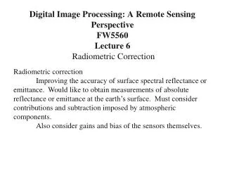
Digital Image Processing: A Remote Sensing PerspectiveFW5560Lecture 6Radiometric Correction Radiometric correction Improving the accuracy of surface spectral reflectance or emittance. Would like to obtain measurements of absolute reflectance or emittance at the earth’s surface. Must consider contributions and subtraction imposed by atmospheric components. Also consider gains and bias of the sensors themselves.
Radiant Flux Density The concept of radiant flux density for an area on the surface of the earth. Irradiance (E) is a measure of the amount of incoming energy in Watts m-2. Exitance (M) is a measure of the amount of energy leaving in Watts m-2.
Radiance (L) is the radiant flux per unit solid angle leaving an extended source in a given direction per unit projected source area in that direction and is measured in watts per meter squared per steradian (W m-2 sr-1 ). We are only interested in the radiant flux in certain wavelengths (L) leaving the projected source area (A) within a certain direction () and solid angle (): L cos This is the most precise remote sensing radiometric measurement.
Energy-matter Interactions in the Atmosphere, at the Study Area, and at the Remote Sensor Detector The total radiance reaching the sensor is:
Primary Focal Plane (PFP), where the silicon detectors for bands 1-4 and 8 are located. A portion of the scene energy is redirected from the PFP to the Cold Focal Plane where the detectors for bands 5, 7, and 6 are located. The spectral filters for the bands are located directly in front of the detectors. Landsat 7 Handbook
The Landsat 7 ETM+ instrument achieves its 185-kilometer cross-track ground swath by using a bi-directional scan mirror to traverse the instrument line-of-sight through a 15-degree cross-track field of view. On descending passes, the mirror alternately scans west-to-east (forward scan) and then east-to-west (reverse scan). The active Earth-imaging portion of each scan lasts for, nominally, 60.743 milliseconds. During this time, the Landsat 7 spacecraft advances approximately 410 meters downtrack.
An estimated 22 percent of any given scene is lost because of the SLC failure. The maximum width of the data gaps along the edge of the image would be equivalent to one full scan line, or approximately 390 to 450 meters. The precise location of the missing scan lines will vary from scene to scene.
Band-specific gap mask files are included with every Scan Line Corrector (SLC)-off Level 1 Terrain (L1T) corrected standard product. These ancillary data allow you to identify the location of all pixels affected by the original data gaps in the primary SLC-off scene. The gap mask is provided as a series of individual band files, in compressed (GZIP) GeoTIFF format. Gap Mask Legend Values: green = primary scene blue = fill scene 1 yellow = fill scene 2 pink = fill scene 3 red = no data (not filled)