Download
1 / 23
470 likes | 1.69k Vues
Latitude and Longitude. How do we find places on maps?. Latitude. What is Latitude? Lines of Latitude run horizontally Latitude is measured in degrees. The Equator is 0 degrees Latitude. Lines of Latitude locate places North or South of the Equator.

E N D
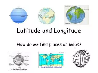
Latitude and Longitude How do we find places on maps?
Latitude What is Latitude? • Lines of Latitude run horizontally • Latitude is measured in degrees. • The Equator is 0 degrees Latitude. • Lines of Latitude locate places North or South of the Equator. • The North Pole is 90 degrees N Latitude, and the South Pole is 90 degrees S Latitude.
Longitude What is longitude? • Lines of Longitude run vertically. • They are also called Meridians. • The Prime Meridian is found in Greenwich, England. • The Prime Meridian is 0 degrees Longitude. • Lines of Longitude locate places East or West of the Prime Meridian. • There are 180 degrees of east Longitude, and 180 degrees of west Longitude.
On the map horizontal lines are lines of latitude and.... vertical lines are lines of longitude. The horizontal line is the equator and the vertical line which runs through Greenwich, England is the Prime Meridian. Equator Prime Meridian
Any location east of the prime meridian is an EAST LONGITUDE
We can divide the Earth into quadrants: NE where all latitudes are NORTH and all longitudes are EAST.
We can divide the Earth into quadrants: SE where all latitudes are SOUTH and all longitudes are EAST.
We can divide the Earth into quadrants: SW where all latitudes are SOUTH and all longitudes are WEST.
We can divide the Earth into quadrants: NW where all latitudes are NORTH and all longitudes are WEST. Notice that EVERY point in the United States will have a NORTH latitude and a WEST longitude since we are in the NW quadrant.
Time Zones • Time zones are broad strips that measure 15 degrees wide. • Time zones differ from their neighboring time zones by 1 hour. • The continental U.S. has 4 time zones, Eastern, Central, Mountain, and Pacific. • In the Spring we shift the clocks 1 hour ahead. This is called Daylight Saving Time. • In the Fall we shift the clocks 1 hour back.
Time Zones (cont…) Local Time and Universal Time Local Time- is what we use everyday, and regulates our lives. Examples of Local Time are: meal time, sleep time, work time, and school time Universal Time- is what we use when we need a time that is agreed upon marking time world-wide. An example when Universal Time was used was when a supernova in 1987 was first seen. Astronomers, and Astronauts use Universal Time..
Longitude and Time • The world rotates (spins) 360° in 24 hours. 360° / 24 hours = 15° per hour • The world has 24 time zones, each l5° apart. **THERE IS A 1 HOUR TIME DIFFERENCE FOR EVERY 15° OF LONGITUDE
Time Zones The International Dateline was established following the 180th meridian, where ever we cross it the date advances 1 day ( if you are going west), or goes back 1 day (if you are going east).
ANOTHER CHEESY SAYING • EAST INCREASE Time is forward to all places to the east • WEST LESS Time is backward to all places to the west
Mapping the Earth • Humans can map just about anything. • The values can change over time. • There are 3 types of fields • Isotherm- temperature • Isobar-air pressure • Contour map- show elevation • Once we measure an area we can make a map of what we are measuring. • We then connect the points that have equal values.
Sample Isoline Map 58 75 87 70 60 80 90 62 60 84 66 75 66 79 70 95 82 70 90 78 86 73 79 74 82 75 80 96 80 94 81 92 81 90 93
Summary 1.What do lines of Latitude and Longitude combine to make? A grid. 2.Compare and Contrast Latitude and Longitude. Latitude- horizontal, north- south, parallels Longitude- vertical, east-west, meridians 3.What is 0 degrees Latitude? Equator 4.What is 0 degrees Longitude? Prime Meridian 5.How many time zones do we have in the U.S.A.? 4- Eastern, Central, Mountain, Pacific 6. Explain the difference between Local Time, and Universal Time. Local time- used everyday Universal Time- is used for a planetary event, or for astronomy 7. What are equal points of temperature, pressure, and elevation called? Isotherm –temperature Isobar – pressure Contour – elevation