HEC-RAS
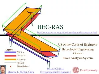
HEC-RAS. Legend. WS 10 yr. WS 50 yr. WS 100 yr. Ground. Bank Station. HEC-RAS. US Army Corps of Engineers Hydrologic Engineering Center River Analysis System. www.wrc-hec.usace.army.mil/. Software for Steady-State Water Surface Profiles.

HEC-RAS
E N D
Presentation Transcript
Legend WS 10 yr WS 50 yr WS 100 yr Ground Bank Station HEC-RAS • US Army Corps of Engineers • Hydrologic Engineering Center • River Analysis System www.wrc-hec.usace.army.mil/
Software for Steady-State Water Surface Profiles • HEC-RAS analyzes networks of natural and man-made channels and computes water surface profiles based on steady one-dimensional flow hydraulics. • includes • composite channels • supercritical-to-subcritical flows • multi-waterway bridges • culvert options • ...
Hydraulic Analysis Components • Steady Flow Water Surface Profiles • flood plain management • flood insurance studies • effects of channel modifications • Unsteady Flow Simulation (future) • model __________ • levee failures • Sediment Transport/Movable Boundary (future) • long term trends of scour and deposition • maximum scour during large flood events • design channel ___________to maintain navigation depths storage contractions
Steady Flow Water Surface Profiles • Systems of channels • network • dendritic • single river reach • Subcritical, Supercritical, and Mixed • Channel Controls/Obstructions • bridge piers • culverts • weirs branching
Computational Procedure • One-dimensional energy equation (_______ ___) • energy losses • friction - Manning Equation • contraction/expansion - loss coefficient • Momentum equation • hydraulic jumps • hydraulics of bridges • stream junctions standard step
Computational Procedure • Assume a water surface elevation at the upstream cross section (or downstream cross section if a supercritical profile is being calculated) • Based on the assumed water surface elevation, determine the corresponding total conveyance and velocity head. ?
= he Computational Procedure • Compute Sf and solve for losses • Solve the energy equation for the water surface • Compare the computed value of depth with the assumed value and ______ until the values agree within 0.01 feet. iterate
Data Requirements • Channel description • length of reach • channel roughness • channel cross-section geometry • Boundary conditions • Structure geometry • bridges • culverts • weirs
River Reach 0.2 10 Tributary F a Upper Reach 0.1 l . l r C River Stations e R t i 9.9 t v e u r B Numeric labels increase upstream 9.8 0.0 Sutter F a l 9.7 l R Lower Reach i v e r 9.6 9.5
Cross Section Data • x-y coordinates of channel bottom • distance to downstream cross-section • Manning’s n
Channel Cross Section Manning n for overbank areas usually higher than for main channel Composite channel calculations...
Channel Section Interpolation • Water surfaces are calculated at each river station • If water depth changes too much between river stations then the calculations are imprecise • Interpolate between rivers stations of known geometry
Inline Weir Station Elevation Editor Weir Editor Resulting cross section
Boundary Conditions • Ways to specify Boundary Conditions • Known Water Surface Elevations • Critical Depth _______________ • Normal Depth _______________ • Rating Curve _______________ • Boundary Condition Requirements • Supercritical Flow ______________ • Subcritical Flow ______________ • Mixed Flow ______________ Mild to Steep Transition Uniform flow Control structure Upstream depth Downstream depth Upstream and Downstream
Program Structure Output Input Cross Sections Channel geometry Profiles Computed Rating Curves Flows and boundary conditions for each profile 3-D Cross Sections Other Analysis Tabular Data Scour at bridges Errors
Change from Mild to Steep Slope From this plot how can you know if flow is super or sub critical? M2 S2
HEC-RAS Summary • HEC-RAS solves the energy and momentum equations to calculate water surface profiles • Modeling natural rivers is made difficult by the need to obtain and enter the geometric data • Currently restricted to steady-state flow
Broad-crested Weir • 3-D Cross Sections
Boundary Condition Editor • Known Water Surface • Critical Depth • Normal Depth • Rating Curve