Download
1 / 1
10 likes | 116 Vues
Discover strain rate models in Southern California using Google Earth. Explore Earth's interior, seafloor age, volcanoes, and more. Presented by Glenn A. Richard from Stony Brook University. Engage with a community of 1.3 million registered users on Google Earth forums.

E N D
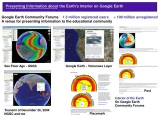
Using Google Earth to Explore Strain Rate Models of Southern California Presenting Information about the Earth's Interior on Google Earth Glenn A. Richard - Mineral Physics Institute, Stony Brook University, Stony Brook, NY 11794-2100 Google Earth Community Forums 1.3 million registered users > 100 million unregistered A venue for presenting information to the educational community Sea Floor Age - USGS Google Earth - Volcanoes Layer Post Interior of the Earth On Google Earth Community Forums Tsunami of December 26, 2004NGDC and me Placemark