Download
1 / 9
100 likes | 407 Vues
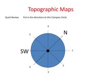
Topographic Maps Quick Review Put in the directions to this Compass Circle. 6. N. 5. SW. 1. 2. 4. 3. Topographic Maps Quick Review Put in the directions to this Compass Circle. Northwest. N. West. SW. Northeast. East. South. Southeast.

E N D
Topographic Maps Quick Review Put in the directions to this Compass Circle 6 N 5 SW 1 2 4 3
Topographic Maps Quick Review Put in the directions to this Compass Circle Northwest N West SW Northeast East South Southeast
A topographic map shows an area, and it of course includes a compass key. The most important part of a topographic map is that it includes lines to show hills and valleys. Each line is called a topographic line. The distance between the lines can be close or far apart, it depends upon how steep or slight the hills are. When the lines are close, the hills are steep. When the lines are far apart, the hills are very much not steep. The elevation between each line is a constant on any map.
This is part of a topographic map. Let’s examine it now. We will assume FEET as a unit. Let’s figure out what’s going on from the “500” to the “X”. What are the numbers for “a” and “b”? What could “c” be? What is the X?
Do the work for the handout questions here, the answers are on the next slide.
x = top, C < 620’ b = 580 feet a = 540 feet This is part of a topographic map. Let’s examine it now. We will assume FEET as a unit. Let’s figure out what’s going on from the “500” to the “X”. What are the numbers for “a” and “b”? What could “c” be? What is the X?
Questions: What is the highest elevation point on this island? What is the lowest elevation on this island? In what direction is the flattest land? In what direction is the steepest hill? Which is the best description of this island?A. 1 high peak B. 2 high peaks C. 3 high peaks D. 2 high peaksand 1 medium high peak How high is the second highest peak? How high is the third highest peak? Mauna Loa, Hawaii N


