Download
1 / 45
450 likes | 615 Vues
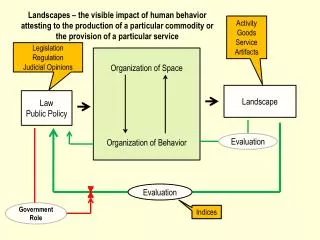
Platting – Subdividing the Land Surface – Subdivision Process – Development Process Fragmenting Space – Real Property Units. The Nature of Landscape. Goods Service Artifacts. Legislation Regulation Judicial Opinions. Organization of Space Organization of Behavior. Law Public Policy.

E N D
Platting – Subdividing the Land Surface – Subdivision Process – Development Process Fragmenting Space – Real Property Units
The Nature of Landscape Goods Service Artifacts Legislation Regulation Judicial Opinions Organization of Space Organization of Behavior Law Public Policy Landscape Evaluation
Landownership comprises • A spatial unit • Legal description • Jurisdiction • A behavioral unit – legal rights in that unit possessed • By individuals • By corporations • By governments Both of these attributes have evolved over time Some make no "sense" in the current setting They can only be appreciated with reference to an appropriate historical setting
Section Subdivision Plat Township
Land System Native American Land Cessions Public Land Surveys Public Land Conveyances Legal System Northwest Territory Michigan Territory Wisconsin Territory A Context Landowners Minnesota Territory Landowners in Minnesota
Plats • A particular type of map showing actual or planned divisions of the land surface • into streets and building lots. • Shows the division of the land and features of the surface relevant to any use of the land – existing rights – pipeline easement, drainage easement – and the topography – hills, wetlands
The first plats showed how deputy surveyors employed by the federal government subdivided the surface into townships and sections • Google Earth • General Land Office Townships
County Surveyors in Minnesota • “in restoring lost or obliterated government corners, the county surveyor shall follow the rules established by or pursuant to acts of Congress, and all such surveys shall be made in strict conformity to the original survey made by the United States” 389.04 • “county boards shall procure and file with the county recorders of their respective counties certified copies of the original plats and field notes of the United States surveys” 389.05 • “When the county board determines that the monuments established by the United States in the public lands survey to mark section, quarter section, and meander corners have been destroyed or are becoming obscure, it may employ a licensed surveyor to preserve, restore and mark the corners with a durable magnetic monument” 381.12
Later plats showed how counties allow this basic division to be further subdivided into blocks with streets, sidewalks, alleys and lots • In order for plats to become valid, a local governing body - in Minnesota a county surveyor - must review and approve them • Plats (Minnesota Statutes) • Plats and Coordinate Surveys (Minnesota Statutes Chapter 505)
Modern Section 31 T28N R22W Modern Corners Me
Subdivision Plat shows the division of land into lots and blocks, and may dedicate lands for public use Manual of Guidelines for Platting in Minnesota
A common interest community plat shows the division of land for condominium, planned communities, and co-op purposesMinnesota Statutes Chapter 515 , 515A, 515B Common Interest Community Plat Manual
Registered land survey is a survey performed to identify registered (Torrens) land Minnesota Statutes Chapter 508 – must be used for registered land - can be used for Abstract land Ramsey County's Manual of Minimum Guidelines for Subdivision Plats (2007 draft)
Abstract Land (Recorder) • Title – ownership interests – evidenced by an abstract of the documents that link the present owner with all past owners • Registered Land – Torrens (Registrar) • Title – ownership interests – evidenced by a certificate of title issued by the District Court
County surveyors are responsible for maintaining the original corner monuments set by the deputies during the • Minnesota Statutes 383D.65 and 389.09 give the County Surveyor the authority to review and approve plats created unde rMS 505 and Common Interest Community (CIC) 515B, and 508 which creates Registered Land Surveys (RLS) • Under Minnesota Statute 389.09 county surveyor must approve Subdivision Plats, Registered Land Surveys (RLS), and Common Interest Community (CIC) Plats before they can be recorded • All plats must be prepared by a land surveyor licensed to practice in the State of Minnesota - Minnesota Statute 505, 515, 515A, 515B, and 508.46-7
Hennepin County Survey Division • Instructions for making plats may be found in Hennepin County's manuals for new subdivisions plats and CIC's • All plats adjoining a county road must be reviewed by the Transportation Department • The Platting Process in Hennepin • Minimum Plat Submittal Requirements • The Plat Review Process • Recording a Subdivision Plat in Hennepin County
Ramsey County Surveyor’s Office • Survey History • Subdivision Plats • Registered Land Surveys • Ramsey County's Manual of Minimum Guidelines for Subdivision Plats • Common Interests Community Plats • Recorded Plats and RLS • Half-Section Maps • Ramsey County Coordinates • GIS • Ramsey County Section Township Range Map
Dakota County Surveyor • Dakota County Plat Commission - The Contiguous Plat Ordinance No. 108 relates to plats and surveys in Dakota County on property contiguous with any existing or proposed county road, pursuant to Laws of Minnesota, 1973, Chapter 416, codified at Minnesota Statute 383D.65 • The County Surveyor serves as the Secretary of the Plat Commission, which reviews all plats adjoining county roads • Dakota County PLS Control Map • Dakota Home & Property • Plats & Surveys – RLS Checking • Plat & CIC Checking • Plat Manuals • Plat Recording Policy
Goodhue County Plats and Maps • Douglas County Public Works, County Surveyor and GIS Division • Carver County Surveyor • GIS Mapping Applications • Plat Maps • Washington County Survey and Land Management Division • Platting land in St Paul (City of St. Paul)
Auditor’s Plat • Not formal subdivision • In order to more easily identify existing parcels of real estate, Minnesota County Auditors sometimes employ a surveyor to draw a map of those existing parcels and give them a lot number designation simply for ease of reference in accounting for real estate taxes • Those shorthand lot numbers are often used later by property owners to describe their property • In spite of the fact that these plats are not formal, legal subdivisions, these maps are a source of information for determining lot sizes, location and dimensions of the real estate contained in them • They also make it much easier to describe a parcel than is the case when relying on the longer, metes and bounds, description from which the lots or parcels contained in the Auditor's Plat originally came
My Property in Sunfish Lake • Dakota County PLS Control Map & Breakdowns • Dakota County Standard Property Map Locator
S1/2 Section 12 T 28N R22W 4th PM 40 acres 40 acres
SW1/4 of SE1/4 Section 12 2 1 4 5 3
Pipeline Easement Highway Easement