Download
1 / 15
150 likes | 281 Vues
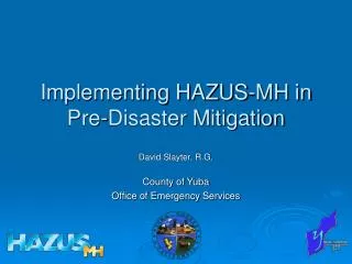
Implementing HAZUS-MH in Pre-Disaster Mitigation. David Slayter, R.G. County of Yuba Office of Emergency Services. What is HAZUS-MH?. (Hazards U.S. – Multi-Hazard). Geographic Information System (GIS)-based software

E N D
Implementing HAZUS-MH in Pre-Disaster Mitigation David Slayter, R.G. County of Yuba Office of Emergency Services
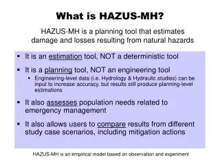
What is HAZUS-MH? (Hazards U.S. – Multi-Hazard) • Geographic Information System (GIS)-based software • Calculates estimated loss due to physical damage from earthquakes, floods, and wind (does not estimate losses due to fire) • Knowing potential losses helps toward: • Improved infrastructure to protect the public and reduce economic losses • Improved planning decision-making
HAZUS-MH Capabilities • Estimates direct physical damage to: • Buildings and their contents • Essential facilities • Bridges and pipelines • Induced damage • Debris generation
HAZUS-MH Capabilities • Direct Losses • Cost of repairs or replacement • Income loss • Agricultural losses • Indirect Losses • Supply shortages • Sales declines
HAZUS-MH Capabilities The estimation is calculated by spatial analysis methods using: • Nationwide databases • Census 2000 • Dun & Bradstreet data of commercial businesses • Nationally-standardized loss estimation and risk assessment methodology • National Institute of Building Sciences (NIBS)-developed loss estimation methods
HAZUS-MH Capabilities Nationwide Databases: • Demographics – Population, Employment, Housing • Building Stock – Residential, Commercial, Industrial • Essential Facilities – Hospitals, Schools, Police Stations, Fire Stations • Transportation – Highways, Bridges, Railways, Tunnels, Airports, Ports and Harbors, Ferry Facilities • Utilities – Waste Water, Potable Water, Oil, Gas, Electric Power, Communication Facilities • High Potential Loss Facilities – Dams and Levees, Nuclear Facilities, Hazardous Material Sites, Military Installations
Earthquake Ground Shaking Ground Failure Flood Frequency Depth Discharge Velocity Hurricane Wind Pressure | Missile | Rain Direct Damage General Building Stock Essential Facilities High Potential Loss Facilities Transportation Systems Utility Systems Induced Damage Fire Following Hazardous Materials Release Debris Generation Direct Losses Cost of Repair Income Loss Crop Damage Casualties Generic Output Shelter Needs Indirect Losses Supply Shortages Sales Decline Opportunity Costs Economic Loss HAZUS-MH Capabilities
Benefits • HAZUS-MH allows the user to: • IDENTIFY vulnerable areas that may require planning considerations • ASSESS level of readiness and preparedness to deal with a disaster before it occurs • ESTIMATE potential losses from specific hazard events (before or after a disaster hits) • DECIDE how to allocate resources for most effective and efficient response and recovery • PRIORITIZE mitigation measures that need to be implemented to reduce future losses
Hazard Scenarios • Flood • Specific Return Intervals • Specific Discharge Frequency • Annualized Losses • Quick Look • Earthquake • Simulate user defined, historic, or probabilistic events
EXAMPLE:HAZUS-MH Flood Model Results • Hazard maps • Flood depth • Building losses • By occupancy and by building type • By full replacement value and depreciated replacement value • Building, content, and inventory losses • Costs of relocation, wage and income losses, rental income loss • Direct employee output losses and employment loss (days)
EXAMPLE:HAZUS-MH Flood Model Results • Essential facilities • Building and content losses • Functionality assessment (yes/no) • Restoration time to 100% functionality • Lifeline losses • Losses to structures and equipment • Functionality assessment (yes/no) • Vehicles and agriculture losses • Shelter requirements
Example HAZUS-MH Output List of schools from HAZUS-MH versus Yuba County GIS m HAZUS fire stations µ Volunteer and City Fire Departments F CDF facilities
Example HAZUS-MH Output Number of students enrolled K-12 Household Income Distribution Wheatland ($ in Thousands) Children Less Than 16 years old (each dot = 3 children) Ethnic Distribution as % Pop. (portion east Marysville)
Example HAZUS-MH Output Building types
Summary • HAZUS-MH will provide the PDM Plan FEMA-approved risk assessment evaluation. • Results will be used to guide mitigation opportunities for at-risk areas. • Motivation for continued maintenance and expansion of Yuba County GIS inventories.