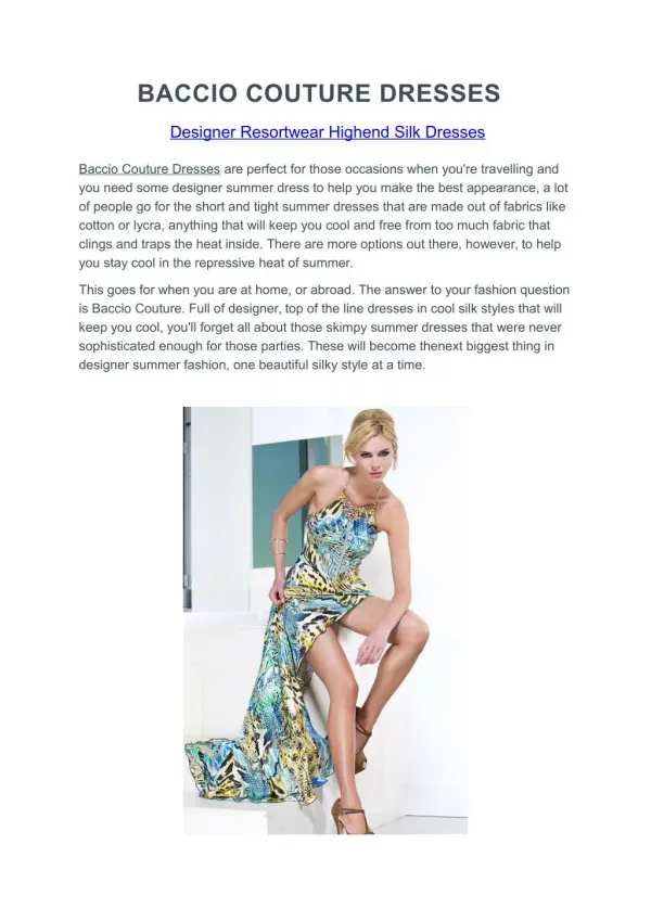
S’COOL Rover
140 likes | 256 Vues
Participate in the S’COOL Rover project as a cloud observer to collect vital data on cloud types, height, cover, and conditions. Your observations will aid NASA in validating satellite data and enhance our understanding of atmospheric clouds and their interactions within the Earth system. The process involves determining satellite overpass times, observing cloud properties, and submitting your findings through a simple online report form. This initiative is ideal for anyone, especially in areas with limited weather data, and provides a rich experience in citizen science.

S’COOL Rover
E N D
Presentation Transcript
S’COOL Rover As a roaming S’COOL Cloud Observer, A Rover, you will collect data on cloud type, height, cover and related conditions. Your observations help us to validate satellite data and give us a more complete picture of clouds in the atmosphere and their interactions with other parts of the integrated global Earth system.Observations are sent to NASA for comparison to similar information obtained from satellite. Reports from a wide range of places are helpful to assess the satellite data under different conditions.
S’COOL Rover The Rover site provides all the information that you need to make and report a cloud observation.We welcome participation from any interested observers, especially from places where official weather observations are few and far between. This Tutorial can help get you started!
S’COOL Rover Rover Observations are simple and involve 4 basic steps: Determining Satellite Overpass Times Observing Cloud Properties Reporting Your Observations to NASA Exploring the Data
1. When to Observe Because cloud properties change rapidly, clouds must be observed at about the same time as the satellite passes over. Visit the Rover site to calculate when a satellite will view your area. https://scool.larc.nasa.gov/en_rover_overpass.html The overpass schedule will provide daily and nightly times when a satellite passes over your area.
1. When to Observe The Terra overpass is in the morning, generally between 10am and noon. The Aqua, CloudSat, CALIPSO, and NPP overpass times are in the afternoon, between 1 and 3pm. Observations can be made during one or both periods depending on your schedule. The Overpass schedule will provide satellite overpass times in UTC time (Universal Time Coordinated) and Local time. Observations should be recorded within +/- 15 minutes of the local overpass time and must be recorded using the 24 hour time format. For example, 2:52 pm would be 14:52.
2. What to Observe and Report Use the Rover report form to report cloud properties. No instruments are needed Surface observations are included in a Rover report and are important. For example, snow and ice can look like clouds from space. Temperature and barometric pressure are also useful observations to report if available.
2. What to Observe and Report The report form focuses on 3 cloud identification properties: 1. Type, 2. Cover, and 3. Visual Opacity.
2. What to Observe and Report Type The S’COOL Rover methods consider 12 different cloud types based on their shape, altitude, and whether they are producing precipitation. An online cloud chart is available with examples http://science-edu.larc.nasa.gov/SCOOL/cldchart.html
2. What to Observe and Report Cover Cloud cover describes how much of the sky is covered Clear (0 to 5%) Partly Cloudy (5 to 50%) Mostly Cloudy (50 to 95%) Overcast (95-100%)
2. What to Observe and Report Opacity Visual opacity of a cloud is defined by how much sunlight is getting through the cloud Transparent Translucent Opaque Examples and tips are available: http://science-edu.larc.nasa.gov/SCOOL/opacity.html
3. Report Your Observations Enter your observation into the Rover On-Line report form Observations do not have to be sent immediately For each rover report you will need to enter A self designated nickname Your email address (to receive satellite data) And your location in latitude and longitude
The final step of the Rover Process is to compare you results with the retrieved satellite data. Because the satellite data does have to be processed it takes some time to receive the match comparisons. When ready, you will receive an email. Comments on the level of agreement between ground and satellite are invited. 4. Explore Data
All ground and satellite data that have been processed are accessible on the internet via the Rover Database. To see these results visit the Rover site and click Explore Data. Search for observations by either a date range or your nickname. 4. Explore Data
For permanent, school or museum-based observation sites, please visit the main web page for the project, Students’ Cloud Observations On-Line, to register to participate.