Oceanography
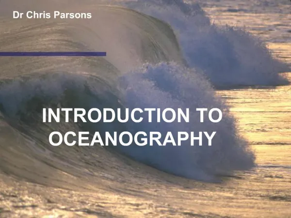
Oceanography. Dr. R. B. Schultz. Oceanography and Our Oceans *71% of Earth's surface is covered with water, so it is important we know something about the water surrounding us.

Oceanography
E N D
Presentation Transcript
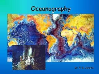
Oceanography Dr. R. B. Schultz
Oceanography and Our Oceans *71% of Earth's surface is covered with water, so it is important we know something about the water surrounding us. Oceanography is the science of our oceans that mixes biology, geology, chemistry, and physics (among other sciences) to unravel the mysteries of our seas. *The Earth has an area of approximately 197 million square miles of which 140 million square miles is water. *The Earth is broken up into hemispheres…Northern and Southern. In the Northern Hemisphere, 61% is water and 39% is land, thus it is called the "Land Hemisphere". In the Southern Hemisphere, 81% is water and 19% is land, thus it is called the "Water Hemisphere".
The Hemispheres of the Earth Northern Hemisphere is approximately 39% land. The Southern Hemisphere is approximately 19% land.
The amount of water present in oceans by volume is much greater than that of the land surface. In fact, the volume of all land is only 1/18 that of the oceans. The average elevation of continents is over 2700 feet above sea level whereas the average depth of the oceans is nearly 12,500 feet. In other words, if the Earth were perfectly spherical, the oceans would cover the land surface to a depth of more than 10,000 feet (nearly two miles). The three major oceans: Pacific is the largest ocean, nearly as vast as the Indian and Atlantic Ocean combined, and has an average depth of ~13,000 feet. Atlantic is the shallowest with an average depth of nearly 11,000 feet. Why is the Atlantic the shallowest? Indian is smallest ocean and is present largely in the Southern Hemisphere.
Composition and Chemistry of Seawater: *Seawater is a complex mixture of water and salts (dissolved minerals) making up about 3.5% of seawater. This may seem small, but if all the water were evaporated, a crust of the remaining salts remaining would be 200 feet thick over the entire earth surface. Salinity is the proportion of dissolved salts to pure water. It is usually expressed in terms of pph, parts per hundred, or percent. But because salts in seawater are small, we usually express it as ppt, or parts per thousand. Main salts/elements present in oceans are in ppt: 1. NaCl (halite) 23.48 (about 2.35%) 2. MgCl 2 4.98 (about 0.50%) 3. Na2SO4 3.92 4. CaCl2 1.10 5. KCl 0.66 6. NaHCO3 (Sodium bicarbonate) 0.192 7. KBr 0.096 8. H3BO3 (Hydrogen borate) 0.026
*Cl-, Na+, SO4--, Mg++, Ca++, and K++ are principle ions present in seawater. *Salinity varies in oceans based on: • the amount of freshwater added to the system or • the amount of evaporation that takes place. • If much evaporation occurs, the water is more saline because water is evaporating faster than freshwater is added. Thus, more salts are left over. *Conversely, the more freshwater added to the system, the less the salinity is. Where do the salts come from? 1. Weathering of rocks/minerals and salts introduced into streams that feed into the oceans. The total quantity of this is on the order of 2.5 billion tons annually. 2. Minerals and salts are also derived from volcanic eruptions, known as outgassing from Earth's interior. We know this is true because certain elements (Cl, Br, S, B) are more abundant in oceans than in Earth's crust. Many speculate that outgassing is responsible for our oceans' formation. 3. Hard parts of marine organisms. (i.e., shell material)
*Surprisingly, the salinity of the oceans is relatively constant. • Although many billion tons of salts are added annually, salts are used in: • making hard parts for ocean creatures (shells), • absorbed by marine plants as nutrients, and • much salts are precipitated out as sediment. • Overall, the oceans naturally tend to chemically mass balance themselves. Resources from Oceans and Seawater: *Some resources that humans currently use from seawater are: • sea salt (halite), • magnesium (a light metal used in the making of light bulbs), • bromine (gasoline additives/fireproofing materials). A great deal of these products in the U.S. come from the Great Salt Lake in Utah, but other countries not having access to the Great Salt Lake, still use the oceans for their resources. *Humans also desalinate seawater to get fresh water. This process is time-consuming, expensive and is not currently economically feasible. Many desalinization plants operate, but few are productive on a commercial scale.
*Gold from our oceans? Yes, gold is present is very low concentrations, but not economic enough to actually "mine" for profit. Many tons of water and sediment would have to be processed in order to get a single ounce of gold. Our Layered Oceans: *Temperature and salinity vary with depth in our oceans, thus the oceans tend to take on a layered effect. Three general layers are present, except in Polar Regions where only one or two layers are present because of coldness: 1. Shallow surface mixed zone (2%): warmest from solar energy, mixed by waves, 1500 feet thick and 70-80 degrees, most saline. 2. Transition zone (18%): includes thermocline, which is point of great drop-off in temperature to ~39 degrees below 5000 feet and halocline, which is point of salinity drop-off, which roughly corresponds to the thermocline. 3. Deep zone (80%): just slightly above or below freezing. Not very saline.
Our Layered Oceans Surface mixing zone is warmest; saltiest near bottom of zone. Transitional zone contains thermocline and halocline. Deep zone is 2 tons per square inch and coldest in temperature.
Ocean Topography: *Oceanographers studying the oceans and ocean floor have delineated three (3) major units: 1. Continental margin 2. Ocean basin floor 3. Mid-oceanic ridges Surprisingly, we know very little about the mapping of our ocean floor. We probably have accurately mapped only 5% of the ocean floor. It is time-consuming, expensive, and our current technology only allows us to map a few miles at a stretch. As technology develops, mapping will improve. Currently, we use echo-sounding devices, which are slow and tedious. 1.The continental margin includes: a.Continental shelf -- very gentle slope (submerged land) b.Continental slope -- steep slope on edge of continental shelf. c.Continental rise -- gentle slope where trenches do not exist Deep sea fans exist where sediment is accumulated and falls off of the continental slope. Mixture of sediment-laden heavy water forms submarine turbidity currents.
Ocean Topography Seamount
What else is at the bottom of the ocean? Answer: Hydrothermal vents …a.k.a… Black smokers!
2.The Deep Sea includes: a.Deep ocean trenches (deepest part of ocean) some as deep as 36,000 feet b.Abyssal plains are the flat portions of the deep ocean, likely to be the flattest portions of the earth. c.Isolated volcanic peaks (mantle hot spots) are referred to as "seamounts". Likewise volcanic cones near mid-oceanic ridges are called seamounts as well. Harry Hess called these “guyots”. d.Mid-oceanic ridges occur where divergent plate boundaries occur (Mid-Atlantic) and the narrow region at the ridge crest is called the rift zone. e.Coral reefs and atolls develop usually in relatively shallow water where light is present and organisms can thrive on nutrients and food sources in a warm water setting. Atolls develop in response to a sinking of the oceanic crust.
Oceans, Waves, Currents, and Tides Ocean circulation: *Involves surface currents and deep-water masses *Some are short-lived: seasonal and local *Others are permanent and extend over large portions of the globe *Generally, circulation patterns of the waters are related to climatic conditions and the heating of the Earth by the sun. *Deep ocean currents are not horizontal like surface patterns but have a vertical component. These are caused primarily by a response to density differences in the ocean and contrasts in temperature and salinity. *Remember, in general, the following are true: 1. Surface salinities increase near the 20-degree latitudes in the Atlantic and Pacific Oceans. 2. Salinities decrease with depth at the halocline near the equator and the Tropics, but increase at high latitudes where there is no halocline. 3. Temperature and density are mostly inversely proportional to each other. 4. Temperatures in the oceans drop at the thermocline except for at high latitudes where they remain constant. Surface Currents: *An important "river" of the ocean is the "Gulf Stream". It flows in response to atmospheric conditions and has a direct relationship with climatic conditions. *Strangely, ocean currents are directed to the right (clockwise) in the northern hemisphere and to the left (counterclockwise) in the southern hemisphere. This has a direct relationship with the Coriolis Effect, which is a deflective force resulting from the Earth's rotation that causes currents to oftentimes move against the winds. *Upwelling is the force that vertically moves cooler water from approximately 1000 feet below the surface to the near surface. Where winds blow towards the equator and parallel to the coastline (ex: west coast of California), surface water movement is deflected away from the coast and deeper water is thrust upward to the surface. This creates a vertical component that causes temperatures drops in surface waters to nearly 10-15 degrees. Thus, extensive nutrients like nitrates and phosphates are "upwelled" to the surface and plankton and other fish populations flourish. Deep Ocean Currents: *In general, deep ocean currents are driven by gravity and density differences. *Two factors are important in creating a dense mass of moving water: 1. Temperature 2. Salinity *Colder and salty water is denser than warmer, less salty water. Thus, deep ocean circulation is referred to as thermohaline circulation. Here's how thermohaline circulation works: Cooler water at the surface (due to heat loss to the atmosphere) becomes saltier (due to much evaporation) and becomes denser, thus it sinks to the bottom. As it sinks it replaces lighter less dense water, which moves back to the zone where the denser water formed. So, cold dense waters flow away from their sources at the poles and are replaced by warmer waters from the lower latitudes. It takes many years, possibly centuries for the dense, saline waters to migrate to the coastlines where upwelling may occur. Tides: Tides are daily fluctuations in the elevations of the ocean waters. They result from gravitational attractions by the moon and sun applied to the Earth. The portion of the Earth directly facing the moon will show a small bulge where the oceans are present because of the attraction for water to the moon and its gravitational forces. Likewise, the side of the Earth directly opposite to the moon will also bulge as a counterbalance to the gravitational pull of the moon. Coastlines: Waves tend to reach the shoreline at an angle and no two waves are identical. But the backwash tends to be perpendicular to the shape of the beach, thus a "zigzag" pattern develops. This is referred to as beach drift and its action can cause beach erosion as well as movement of sediment and particles many feet down the beach. The oblique waves that crash against the shorelines develop currents that take sand and sediment headlong parallel to the beach and is referred to as longshore current. This process is significant and has been measured to carry millions of tons of sand and sediment away from the beaches along the California Coast every year. Two types of coastlines: 1.Emergent coastline: where land that was formerly below sea level has been exposed due to crustal uplift or a drop in sea level. 2. Submergent coastline: where land that was formerly above sea level has been submerged due to rise in sea level or a crustal dropping (subsidence).
Surface Currents: *An important "river" of the ocean is the "Gulf Stream". It flows in response to atmospheric conditions and has a direct relationship with climatic conditions. *Strangely, ocean currents are directed to the right (clockwise) in the northern hemisphere and to the left (counterclockwise) in the southern hemisphere. This has a direct relationship with the Coriolis Effect, which is a deflective force resulting from the Earth's rotation that causes currents to oftentimes move against the winds. *Upwelling is the force that vertically moves cooler water from approximately 1000 feet below the surface to the near surface. Where winds blow towards the equator and parallel to the coastline (ex: west coast of California), surface water movement is deflected away from the coast and deeper water is thrust upward to the surface. This creates a vertical component that causes temperatures drops in surface waters to nearly 10-15 degrees. Thus, extensive nutrients like nitrates and phosphates are "upwelled" to the surface and plankton and other fish populations flourish.
Cold Water Upwelling Hurricane causing algal bloom in upper portion of ocean.
Shallow Ocean Currents El Niño and La Niña
Deep Ocean Currents: *In general, deep ocean currents are driven by: • gravity and • density differences. *Two factors are important in creating a dense mass of moving water: 1. Temperature 2. Salinity *Colder and salty water is denser than warmer, less salty water. Thus, deep ocean circulation is referred to as thermohaline circulation. Here's how thermohaline circulation works: Cooler water at the surface (due to heat loss to the atmosphere) becomes saltier (due to much evaporation) and becomes denser, thus it sinks to the bottom. As it sinks it replaces lighter less dense water, which moves back to the zone where the denser water formed. So, cold dense waters flow away from their sources at the poles and are replaced by warmer waters from the lower latitudes. It takes many years, possibly centuries for the dense, saline waters to migrate to the coastlines where upwelling may occur.
Key Terminology Oceanography Land Hemisphere Water Hemisphere Hydrologic cycle Hydrosphere Pacific Ocean Atlantic Ocean Indian Ocean Salinity Desalinization Layered Oceans Surface mixing zone Transitional zone Deep zone Continental margin Continental shelf Continental slope Continental rise Abyssal plains Seamounts (Guyots) Deep sea fan Turbidity current Photic zone Aphotic zone Echo sounding Deep ocean trenches Coral reefs Atolls Gulf Stream El Niño/La Niña Coriolis Effect Upwelling Thermohaline circulation patterns