Watershed Location
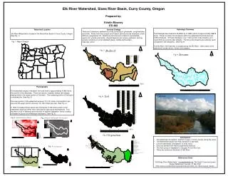
Elk River Watershed, Sixes River Basin, Curry County, Oregon. Prepared by: Kristin Mooney ES 492. Hydrologic Summary

Watershed Location
E N D
Presentation Transcript
Elk River Watershed, Sixes River Basin, Curry County, Oregon Prepared by: Kristin Mooney ES 492 Hydrologic Summary The drainage area measures 35,480m by 21,960m which is approximately 58678 acres. There is a total of 9 sub-basins within the watershed that includes over 2,050 tributaries. Of those tributaries, over 1,000 are first order streams, and nearly 500 are second order streams. The first order streams are relatively warm compared to the tributaries. (See Fig. 9) The Elk River Fish Hatchery is located along the Elk River. Other users of the watershed include miners, fishers and campers. Watershed Location Elk River Watershed is located in the Sixes River Basin in Curry County, Oregon. (See Fig. 1) General Geology There are Cretaceous sedimentary rocks consisting of greywacke, conglomerates and shale. Rocks from the Jurassic and Triassic periods include mudstone, shale, siltstone, greywacke, tuff, limestone and intrusives of felsic to intermediate, quartz-rich, granite and diorite. Recent deposits are terrace, pediment, and lag gravels consisting of unconsolidated gravel, cobble and boulders. (See figs. 4 & 5) Fig. 1 Map of Oregon Fig. 7 Fig. 9 Physiography The watershed ranges in elevation from sea level to approximately 4,080 feet at the summit of Iron Mountain. There are narrow, forested, valleys with steeply sloping sides in the upper portion of the basin. The remaining portion of the basin is relatively flat. (See Fig. 2) The lower portion of the watershed receives 70-100 inches of precipitation per year and the upper portion receives 100-180 inches per year. (See Fig. 4) In 1930, European Beach grass was introduced. In the lower portion of the watershed, large log "drifts“ were removed for agricultural development. This resulted in loss of wetlands and reduction of riparian vegetation, which is being overtaken by gorse and Himalayan blackberry. (See Fig. 5) Elk River Fig. 8 Fig. 2 Fig. 3 http://memory.org/point.b/image/img_1277.jpg Fig. 5 • Conclusions • The watershed is located in southern oregon, in Curry county, along the coast. • The Watershed ranges from high elevation to sea level. • Like all watersheds, precipitation is a key factor. • Soils are derived from mainly sedimentary bedrock. • The main group of vegetation is Douglas Fir and Tan Oak. • There are numerous tributaries off Elk River. Fig. 6 Fig. 4 References Cited "Elk/Sixes River Watersheds." currywatershed.org. The South Coast and Lower Rogue Watershed Councils. 21 Mar 2007 <http://www.currywatersheds.org/watersheds.php?idlnk_art=15&mod=page_master>.