Download
1 / 1
10 likes | 106 Vues
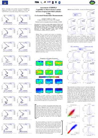
This study evaluates HIRDLS' ozone detection capability in lower stratosphere using WOUDC ozonesonde data. The analysis includes statistical assessment of HIRDLS accuracy across latitudes from 45°S to 79°N during ozone lamina events.

E N D
Percent Difference (H-S)/S Mean Std Dev 79oN 59oN Subset: 57% Subset: 30% Jan06 Feb06 Mar06 Subset: 34% Apr06 May06 Jun06 Jul06 Aug06 Sep06 Percent Difference (H-S)/S Mean Std Dev Oct06 Nov06 Dec06 Assessment of HIRDLS Capability to Detect Ozone Lamina in Extra-tropical and Mid-Latitudes Using Co-Located Ozonesonde Measurements Below: coincident ozone profiles measured with HIRDLS (improvedv2.04.19, soon-to-be released as V004) and with WOUDC ozonesondes during UTLS lamina events. HIRDLSOzone [v2.04.19] - Accuracy As A Function Of Latitude B. Nardi1, V. Yudin1, J. C. Gille1, T. Massie1, R. Khosravi1,L. L. Pan1, S. W. J. Randel1 1National Center for Atmospheric Research, Boulder, CO 80301 Ozonesonde data is used that was made available though the WOUDC by the following PIs: P. von der Gathen (AWI-NA: Ny Aalesund); J. Davies (MSC: Churchill, Kelowna, Eureka, CA); H. De Backer (RMIB: UCCLE, BEL); R. Stubi (MeteoSwiss: Payerne, CHE); F. J. Schmidlin (NASA-WFF: Wallops Island, USA); B. Kois (PIMWM: Legionowo, POL); S. Pavla (CHMI-PR: Praha,CZE), B. Calpini (MeteoSwiss: Nairobi, KEN); F. Posny (Univ.LaReunion); G. Bodeker (NIWA-LAU: Lauder, NZ). 47oN 38oN 1oS 21oS 45oS Abstract There is currently much interest in stratosphere-troposphere exchange and in the associated poleward transport of upper tropospheric air into the lower stratosphere along a secondary tropopause. These events are especially prevalent in NH winter mid-latitudes. HIRDLS measurements of ozone and temperature during these events confirm that low ozone lamina and pockets are associated with these intrusions. HIRDLS, with its demonstrated ability to measure ozone in the lower stratosphere with approximately 1 km vertical resolution, is the first satellite instrument with sufficient vertical resolution and coverage to observe many such events in the upper troposphere / lower stratosphere [UTLS]. Presented here are co-located measurements of HIRDLS ozone profiles and WOUDC-site ozonesonde profiles on multiple such events. We use these co-located measurements to provide an assessment of the ability of HIRDLS to detect these events. Shown above is the accuracy of HIRDLS ozone, v2.04.19, as determined statistically by a average of the differences between HIRDLS and ozonesonde ozone values for 8 WOUDC sites spanning latitude range 45 degrees S to 79 degrees N. Numbered in blue and black in the upper right of each panel is the number of HIRDLS and sonde profiles, respectively, of which the dataset is comprised. ALL coincidences Lamina cases only Frequency of Lamina Occurrence Three particularly rich datasets are used to determine whether the highly structured lamina profiles produce a larger mean differences, interpretable as lower HIRDLS accuracy, during the most demanding measurement scenarios posed by the highly structured features. On the left hand side are the mean difference profiles for all coincident profiles from years 2005, 2006 and 2007 combined, for the three WOUDC sites. On the right hand side are the mean difference profiles for the same sites, but only including the coincident profiles in which lamina were present. If HIRDLS has difficulty measuring the large vertical gradients you would expect either the difference and/or the standard deviation in those regions to increase. The fact that this is not the case is evidence that HIRDLS the large vertical gradients do not cause a significant degradation in the accuracy of HIRDLS ozone. The frequency of lamina occurrence as measured with HIRDLS ozone, is determined by counting profiles where the ozone mixing ratio falls below a threshold value at the 100 hPa pressure level. The ratio of the number of lamina profiles to the total number of profiles is plotted on Mercator Maps above for each month in 2006. To the left are coincident ozone profiles during lamina events. Profiles are compared from eight World Ozone and Ultra Violet Data Center (WOUDC) sites in the NH at mid and high latitudes spanning range 38 degrees N to 79 degrees N. The coincidence criteria used are temporal and spatial separation of less than 500 km and 12 hrs respectively. The black dots are the sonde measurement and the color lines are HIRDLS profiles, the closest coincident profile being in bold-blue. One can see clearly that the large vertical ozone gradients associated with the ozone lamina are captured very well in the HIRDLS profiles. The statistical difference of the full set of coincident lamina profiles for the three stations above, as well as the Legionowo and Wallops Island stations is shown at the far right, in terms of partial pressure (top), volume mixing ratio (middle) and percent difference (bottom). Consistent with individual station statistics, a 10% accuracy to pressures of about 200 hPa are indicated. Scatter plots (near right) of all profile data-points in terms of partial pressure (top) and volume mixing ratio (bottom) are shown. Correlations between the two datasets are very high, at 0.97 for VMR and 0.79 for partial pressure.