Exploring Different Types of Clouds: A Classroom Presentation by Mrs. Garza
In this engaging presentation, Mrs. Garza introduces her fourth-grade students to the fascinating world of clouds. The presentation features a slide show that covers four distinct types of clouds: Stratus, Cirrus, Altocumulus, and Cumulus. Each slide includes vibrant graphics and informative bullet points, providing a clear understanding of their characteristics and significance in weather forecasting. As part of the learning experience, the presentation utilizes animation techniques to enhance comprehension, making it an interactive and educational exploration of cloud types.

Exploring Different Types of Clouds: A Classroom Presentation by Mrs. Garza
E N D
Presentation Transcript
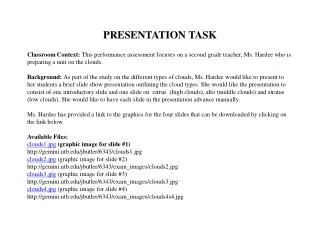
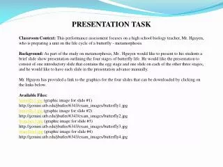
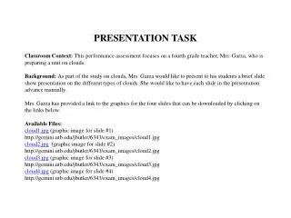
PRESENTATION TASK Classroom Context: This performance assessment focuses on a fourth grade teacher, Mrs. Garza, who is preparing a unit on clouds. Background: As part of the study on clouds, Mrs. Garza would like to present to his students a brief slide show presentation on the different types of clouds. She would like to have each slide in the presentation advance manually. Mrs. Garza has provided a link to the graphics for the four slides that can be downloaded by clicking on the links below. Available Files: cloud1.jpg (graphic image for slide #1) http://gemini.utb.edu/jbutler/6343/exam_images/cloud1.jpg cloud2.jpg (graphic image for slide #2) http://gemini.utb.edu/jbutler/6343/exam_images/cloud2.jpg cloud3.jpg (graphic image for slide #3) http://gemini.utb.edu/jbutler/6343/exam_images/cloud3.jpg cloud4.jpg (graphic image for slide #4) http://gemini.utb.edu/jbutler/6343/exam_images/cloud4.jpg
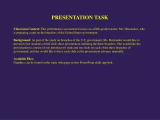
The Task: Mrs. Garza has asked the Master Technology Teacher for assistance in creating the presentation. Using your knowledge of presentation software, create a model slide show presentation to Mrs. Garza’s specifications. In creating this presentation, you should: • Create an introduction slide that provides the subject, date and teacher’s name. • Create slides 2 through 5 using the five files provided by Mrs. Garza. Each slide should • Contain a title, an appropriate graphic image and text provided displayed as a bulleted list. • Animate the entry of the text of slides 2 and 4 (the animations should occur • Automatically and not require a mouse or keyboard click). • Animate the entry of the graphics in slides 3 and 5 (the animations should occur automatically and not require a mouse or keyboard click).
(Slide # 3)Altocumulus clouds Middle level clouds that are made of water droplets Appear as gray, puffy masses, sometimes rolled out in parallel waves or bands. Often means thunderstorms may occur (Slide # 4)Cumulus clouds Puffy clouds that sometimes look like pieces of floating cotton Base of each cloud is often flat and may be only 1000 m (330 ft) above the ground Top of the cloud has rounded towers.. These clouds grow upward All photographs from http://eo.ucar.edu/webweather/ (Slide # 1)Stratus clouds Uniform grayish clouds that often cover the entire sky. Resemble fog that does not reach the ground. No precipitation but sometimes they may drizzle. When a thick fog "lifts," the resulting clouds are low stratus. (Slide # 2)Cirrus clouds Thin, wispy clouds blown by high winds into long streamers. They are considered "high clouds" forming above 6000 m (20,000 ft). Usually move across the sky from west to east. They generally mean fair to pleasant weather.
Science Clouds April 15, 2012 Mrs. Garza
Stratus Clouds • Uniform grayish clouds that often cover the entire sky. • Resemble fog that does not reach the ground. • No precipitation but sometimes they may drizzle. • When a thick fog "lifts," the resulting clouds are low stratus.
Cirrus Clouds • Thin, wispy clouds blown by high winds into long streamers. • They are considered "high clouds" forming above 6000 m (20,000 ft.). Usually move across the sky from west to east. • They generally mean fair to pleasant weather.
Altocumulus Clouds • Middle level clouds that are made of water droplets • Appear as gray, puffy masses, sometimes rolled out in parallel waves or bands. • Often means thunderstorms may occur
Cumulus Clouds • Puffy clouds that sometimes look like pieces of floating cotton • Base of each cloud is often flat and may be only 1000 m (330 ft.) above the ground • Top of the cloud has rounded towers. • These clouds grow upward All photographs from http://eo.ucar.edu/webweather/