Download
1 / 36
380 likes | 641 Vues
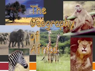
GEOGRAPHY OF AFRICA. SS7G1 The student will locate selected features of Africa.

E N D
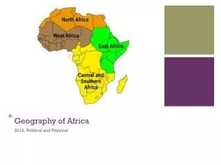
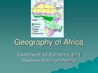
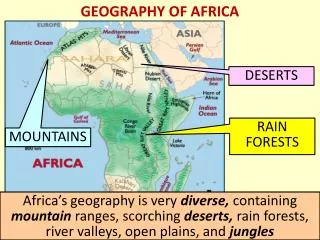
GEOGRAPHY OF AFRICA • SS7G1 The student will locate selected features of Africa. • a. Locate on a world and regional political-physical map: the Sahara, Sahel, savanna, tropical rain forest, Congo River, Niger River, Nile River, Lake Tanganyika, Lake Victoria, Atlas Mountains, and Kalahari Desert. • b. Locate on a world and regional political-physical map the countries of Democratic Republic of the Congo (Zaire), Egypt, Kenya, Nigeria, South Africa, Sudan, and South Sudan.
Facts about the Nile River • It is the longest river in the world • It flows through the following countries: Kenya, Eritrea, Congo, Burundi, Uganda, Tanzania, Rwanda, Egypt, Sudan, South Sudan and Ethiopia. • The Nile Delta in Northern Egypt is where the Nile River drains in to the Mediterranean Sea. • The Aswan High Dam was built in 1970 to help regulate flooding of the Nile River. Before the Aswan Dam was built, years that featured high levels of water could wipe out crops while years of low level water could produce famines and drought. The dam helps control these water levels.
Atlas Mountains Facts • The Atlas Mountains span across three countries: Morocco, Algeria and Tunisia. • Highest point - Jbel Toubkal (13,671 feet) • People - The Berbers. They are natives who speak Arab languages. • Mostly grassland and no trees. However, the middle of the range is heavily forested. • The Atlas Mountains contain a wide variety of mineral deposits, including gold, silver, lead, zinc, iron, manganese, antimony, phosphates, and petroleum.
Tropical Rain Forest Facts • Dense evergreen forest with an annual rainfall of at least 60 inches. • The rainforest has shrunk because of deforestation and destructive farming practices • Part of the rainforest is in Ghana and 2/3rds is in the Democratic Republic of Congo
The Congo River Facts • The Congo River is the main transportation source in Central Africa. • A tremendous amount of goods are transported on the river every day. • It is the second longest river in Africa. • The Congo River is an extremely powerful river; there are approximately forty hydropower plants along the river that utilize this power to provide energy for the African continent.
Lake Tanganyika Facts • It is the second largest lake in Africa • It is the deepest lake in Africa • has important fisheries and there are large populations of hippopotamuses and crocodiles
Sahara Desert Facts • The world’s largest desert • Bordered on the north by the Atlas Mountains • A trade route – goods transported between European and African nations • Most populous area is Cairo, Egypt • It is defined by its climate – very hot and dry
Savannah Facts • Tropical grasslands with scattered trees • Home to an amazing variety of wildlife • The most famous savannah is the Serengeti, which includes parts of Kenya • Grazing land for cattle, goats, and sheep
Sahel Facts • Strip of semi-arid land south of the Sahara • Some areas rich in natural resources • It depends on farming, so it can be devastated by bad weather • 1970 drought caused 200,000 people to die from starvation; this caused many people to move to cities; but the cities cannot handle the population increase so many live without electricity, running water, or proper sewers
Kalahari Desert Facts • Covers 360,000 square miles • Located in South Africa, Botswana, and Namibia • It is semi-arid, meaning it contains a few more plants and wildlife than a traditional desert • Some of the world’s largest diamond mines are found here
Niger River Facts • Third longest river in Africa • Located in western Africa • Source is the Guinea Highlands
Lake Victoria Facts • Largest lake in Africa • Bordered by Uganda, Kenya, and Tanzania • Named after Queen Victoria of England • 80% of its water comes from rain • Largest tropical lake in the world