Download
1 / 74
740 likes | 836 Vues
GEOGRAPHY OF AFRICA. BASIC FACTS. Second largest continent Could fit 3 of the U.S. Most independent countries (54). 11,668,545 square miles that’s over 11 billion football fields.

E N D
BASIC FACTS • Second largest continent • Could fit 3 of the U.S. • Most independent countries (54)
11,668,545 square miles • that’s over 11 billion football fields. • If you were to give each person on earth - that's almost 6 billion people - land in Africa, you could give everyone almost two football fields • Pennsylvania = 46,058 square miles Approximately 253 PA’s would fit inside Africa!
Location • Distance north and south of equator • 80% of Africa is in the TROPICS • CANCER-CAPRICORN • Climate: Warm all year
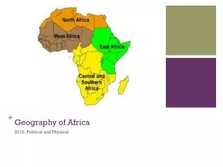
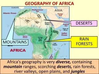
REGIONS • North Africa (Morocco-Egypt) • West Africa (Sahel: Coastline) • East Africa • Central Africa • Southern
Natural Resources • West: Gold Coast • Copper: Zaire • Platinum: S.A. • Oil: Libya
Looking at your large map…what do you notice about the elevation of Africa?
Elevation • Height above sea level • Temperature drops as elevation increases • Accra, Ghana: 80’s • Nairobi, Kenya: 60’s
LANDFORMS • Mostly plateaus (Tilts to NW) • Escarpments: Steep cliffs • Cataracts: Waterfalls
Landforms • Great Rift Valley • Volcanic activity • Why historically, might this area be significant?
The Great Rift Valley • Huge “cut” in the Earth’s crust • Extends from Syria to Mozambique • Formed when tectonic plates pulled away from one another – land slid between the plates creating a valley
Land formsEscarpments • Steep cliffs that divide the Plateau from the costal plain
What do you think is the most important geographic feature of Africa?
RIVERS • Key to African society Why? Food Irrigation Transportation
Egypt Longest river (4160 miles) Early civilizations Aswan Dam Central Africa Can’t travel on NILE ZAIRE
Nile River • Longest river in the world. 4160 miles. • Played a key role in human development
ASWAN HIGH DAM • Why Built? • Irrigation • Feed growing population • Power • Protects vs flooding • Symbol of Nasser’s Power
Provides water for farmers Major source of fish Victoria Falls Kariba Dam provides hydroelectric power NIGER ZAMBEZI
ZAMBEZI • Kariba Dam provides hydroelectric power
Negative Impact: • The dam causes flooding in other regions • Diseases have increased since its construction • SCHISTOSMIASIS • FROM PARASITIC WORMS
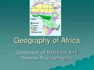
4 CLIMATE ZONES • Tropical Wet • Savanna • Desert • Mediterranean
Tropical Wet • Central and West Africa • Avg Temp: 80 degrees • Rainfall: 60-120 in • Leaching: Minerals dissolved • Disease: Malaria, Tsetse Fly
Savanna • Largest climate zone • Grasslands • Summer: Hot+Wet • Winter: Warm+Dry • Drought: Periods w/o rain • Desertification: land into desert
Savanna-½ of Africa is Tropical Wetand Dry-largest climate in Africalittle rain in Winter
DESERTS • Covers 40% of Africa • Sahara • LARGER THAN U.S. • 10 YEARS W/O RAIN • Kalahari: South Africa • Namib: One of driest places
Desertification Desertification could displace up to 50m people over the next decade The process of land turning to desert
Deserts Tree-planting schemes may put pressure on scarce water resources