Thunderstorm and Turbulence Avoidance
Thunderstorm and Turbulence Avoidance. REFERENCES. TC 1-218, Aircrew Training Manual Utility Airplane 2 March 1993 AR 95-1, Flight Regulations, 1 September 1997 Aeronautical Information Manual (AIM) FM 1-230, Meteorology for Army Aviators, 30 September 1982

Thunderstorm and Turbulence Avoidance
E N D
Presentation Transcript
REFERENCES • TC 1-218, Aircrew Training Manual Utility Airplane 2 March 1993 • AR 95-1, Flight Regulations, 1 September 1997 • Aeronautical Information Manual (AIM) • FM 1-230, Meteorology for Army Aviators, 30 September 1982 • “Thunderstorms - Up (Too) Close and Personal”, Flying Safety, June 1998
OUTLINE • Thunderstorm Formation • Weather Radar • Thunderstorm Avoidance • Turbulence/Turbulence Avoidance
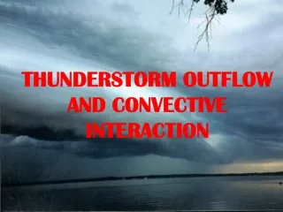
THUNDERSTORMS • Thunderstorm Facts • Can occur anywhere in the world and at any time of the day. • Nearly 1,800 thunderstorms are occurring at any moment. • Over 40,000 form every day around the world • All thunderstorms produce lightning and thunder, with the potential to produce damaging straight-line winds, large hail, heavy rain and flooding, and tornadoes. • A thunderstorm is classified as severe when it contains one or more of the following phenomena: • Hail 3/4” or greater • Winds gusting in excess of 50 Knots (57.5 mph) • A Tornado
Thunderstorm Types • Frontal: • Warm-front Thunderstorms • Cold-front Thunderstorms • Prefrontal Squall-line Thunderstorms • Stationary-front Thunderstorms • Occlude-front Thunderstorms • Air Mass Thunderstorms • Convective Thunderstorms • Orographic Thunderstorms
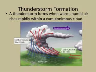
Thunderstorm Formation Three Stages of Thunderstorm Development • Cumulus (Building) Stage • Mature Stage • Dissipating Stage
Cumulus Stage • Rising of warm moist air during the day will form a cumulus cloud. • The cloud will continue to grow as long as the warm moist air continues to rise. • Formation of a cumulus cloud could take as little as a few minutes.
Mature Stage • Raindrops start to fall through the cloud when the rising air can no longer hold them up. • Cool dry air starts to enter the cloud and because it is heavier than warm air, it starts to descend in the cloud (known as a downdraft). The downdraft pulls the heavy water downward, making rain. • This cloud has become a cumulonimbus cloud because it has an updraft, a downdraft, and rain. • Lightning and thunder start to occur, as well as heavy rain. The cumulonimbus is now a thunderstorm cell
Dissipating Stage • After about 30 minutes, the thunderstorm begins to dissipate. • This occurs when the downdrafts begin to dominate over the updraft. • Since warm moist air can no longer rise, cloud droplets can no longer form. • The storm dies out with light rain as the cloud disappears from bottom to top.
Weather Radar 1. Aircraft radar set generates an electromagnetic pulse 2. Pulse is directed toward a reflecting body 3. Pulse is reflected back to the source 4. Radar Set receives the signal and displays the results
Weather Radar 4 1 2 3
Weather Radar Scalloped Edge, Fingers and U-shaped echoes are all indicative of potential Hail. Hail has been associated with these types of returns
Weather Radar Although they may occur in any Thunderstorm, Tornadoes have been associated with hook, bow and pendant (figure 6) shaped returns.
Tornadoes (cont.) Pendant Shape Notches, Fingers and Hooks
Weather Radar Targets with asymmetric coloring and shapes. Severe storms created by windshears aloft will tilt to one side. This gives shapes and colorings that are not even or concentric. Targets with an "arrow shape." Again, this is indicative of a storm with tilt and the possibility of severe hazardous weather.
Weather Radar Potential Downwind Hail Hail falls many times outside of the thunderstorm. Checking the winds at altitude and correlating it to the side of the storm that hail will fall should help identify that potential hazard.
Rain Gradient Steep Gradient Shallow Gradient Heavy Heavy Rain Moderate Moderate Light Light Clear Clear
Weather Radar Images The steeper the gradient, the more sever the turbulence Circle/Oval Shapes A gradient is considered steep when the distance from the edge of the echo to the edge of the red display is 3 NM or less. Steep Gradient
Thunderstorm Planning Considerations • Surface dew point and temperature are a good indicator of storm severity. Thunderstorms forming over an area where the dew point is 50 F or higher with more than a 30 degree spread between temperature and dew point indicate a potential for extremely strong storms. • Use the antenna tilt feature effectively to identify tops of the moisture and to determine if rain is so heavy that it is attenuating the radar beam. • If winds at 18,000 feet (500mb level) are southwesterly, you can expect storms to form. • Consider flying in the morning before the afternoon heat can trigger storms. • Consider delaying takeoff when a cell is within 20 miles of the departure airport.
AR 95-1 Flight Restrictions Thunderstorms Aircraft will not be intentionally flown into Thunderstorms
Thunderstorm Do’s and Don’ts DON’TS • Don’t take off or land in the face of an approaching T-storm • Don’t attempt to fly under a T-storm • Don’t fly into a cloud mass containing embedded T-storms without weather radar • Don’t trust visual appearances to be an indicator of turbulence inside a T-storm
Thunderstorm Do’s and Don’ts • DO’S • Do avoid by at least 20 NM all T-storms identified as severe. • Do clear the tops of a known or suspected severe T-storm by 1000’ for every 10 knots of wind at the cloud tops. • Do circumnavigate the entire area if there is 6/10 T-storm coverage. • Do remember that vivid and frequent lightning indicates the probability of a strong thunderstorm. • Do regard as extremely hazardous any storm with tops 35,000 feet or higher. • Provide extra distance from cells moving at 20 knots or greater and the cell at the south end of a line of storms. This cell does not have to compete for moisture with other cells so it has an abundant "fuel" supply to generate turbulence.
Enroute Avoidance Procedures • Avoid flight under a CB overhang if possible • Above 23,000 feet avoid all echoes by 20 NM • Below 23,000 feet: • Avoid echoes having steep gradients by at least 5 NM when OAT is 0oC or warmer • Avoid echoes having steep gradients by 10 NM when OAT is less than 0oC. • Increase distances by 5 NM for rapidly changing echoes or those that exhibit hooks, figure-6’s, U-shapes, scalloped edges, or other forms of protrusions • Weak echoes may be flown through, or near, if avoidance is impossible or impractical.
Fatal Turbulence Events Since 1980 10May80; Indian Airlines 737-200; near Rampur Hat, India: Aircraft experienced severe en route turbulence. Two of the 132 passengers were killed. 7Oct81; NLM CityHopper F28-4000; Moerdijk, Netherlands: Shortly after takeoff, the aircraft entered an area of severe thunderstorm activity. The aircraft apparently had a catastrophic in flight structural failure due to severe turbulence because it was seen to emerge from the clouds with one of its wings broken away. All four crew members and 13 passengers were killed. 16Aug82; China Airlines 747; near Hong Kong: The aircraft encountered severe in flight turbulence. Two of the 292 passengers were killed. 3Oct90; Eastern DC9-31; Florida, USA: The aircraft encountered clear air turbulence at 31,000 feet (9450 m). One injured passenger died three weeks later. 5Sept96; Air France 747-400; near Ouagadougou, Burkina Faso: Severe turbulence associated with a weather front seriously injured three of the 206 passengers. One of the three passengers later died of injuries caused by an in flight entertainment screen. 28Dec97; UA 747-100; over Pacific Ocean near Japan: Aircraft encountered severe turbulence during cruise about two hours after departing Japan. One of the 346 passengers was killed. 3 of the 23 crew members sustained serious injuries.
AR 95-1 Flight Restrictions Turbulence • Turbulence • Aircraft will not be intentionally flown into known or forecast extreme turbulence or into known severe turbulence. • Aircraft will not be flown into forecast severe turbulence unless MACOM Commander has established clearance procedures and -
Flight into Severe Turbulence • Weather info is based on area forecast • Flight will be made into areas where severe turbulence is unlikely • Flights are for essential training or essential missions only • Flight approval authorities are specified • Flights are terminated or depart turbulence if severe turbulence is encountered Clearance Procedures
Turbulence Intensity Levels • Light • Moderate / Moderate Chop • Severe • Extreme
Light Turbulence Aircraft Reaction • Momentary changes in aircraft altitude and attitude. Reaction Inside the Aircraft • Occupants may feel a slight strain against seat belts. • Unsecured objects may be displaced slightly.
Moderate Turbulence Aircraft Reaction • Changes in the aircraft’s altitude and attitude • The aircraft remains in positive control at all times • Usually causes variations in indicated airspeed • Moderate Chop - causes rapid bumps or jolts without appreciable changes in altitude or attitude Reaction Inside the Aircraft • Occupants feel a definite slight strain against seat belts. • Unsecured objects are dislodged.
Severe Turbulence Aircraft Reaction • Causes large abrupt changes in altitude and/or attitude. • Causes large variations in indicated airspeed • Aircraft may be temporarily out of control Reaction Inside the Aircraft • Occupants are forced violently against seat belts or shoulder straps. • Unsecured objects are tossed about.
Extreme Turbulence Aircraft Reaction • The aircraft is violently tossed about and is practically impossible to control • May cause structural damage Clear Air Turbulence (CAT) High level turbulence (normally above 15,000) not associated with cumuliform clouds should be reported as CAT
Turbulence Frequency Occasional - Less than 1/3 of the time Intermittent - 1/3 to 2/3 of the time Continuous - More than 2/3 of the time
Summary • Three Stages of Thunderstorms: • Cumulus, Mature, and Dissipating Stages • Weather Radar Returns • Thunderstorm Avoidance Criteria • Above FL230 - 20NM • Below FL230 - 5 NM above 0oC; 10 NM below 0oC • Turbulence