Weather
Weather Weather is comprised of the elements of: Air temperature Air Pressure Humidity Clouds Precipitation Visibility Wind

Weather
E N D
Presentation Transcript
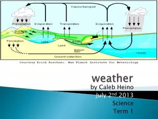
Weather • Weather is comprised of the elements of: • Air temperature • Air Pressure • Humidity • Clouds • Precipitation • Visibility • Wind • If we measure and observe these weather elements over a specified interval of time, we would obtain the “average weather” or the climate of a particular region. The concept of climate also includes the extremes of weather, meaning, we also keep the frequency of the extreme events together with the averages.
Radiation Budget All aspects of the climate system of the earth is determined by the radiation earth receives from the sun. Variations in the amount of energy we receive from the sun and the amount of energy we lose to space create the temporal and spatial variations in energy exchanges which lead to our climate. The energy comes from the sun in the form of visible light and as infrared radiation. Some of the energy is reflected from the earth, and some of it is radiated back into space as infrared radiation. The radiated energy obeys Stefan-Boltzmann Law: E = s T4 where s is a constant. This law is for perfect black bodies, and as the earth is not a perfect blackbody we must modify this equation slightly: E = es T4 where e is the emissivity which is around 0.9 for most of earth’s surface.
Energy Balance Incoming Radiation = Outgoing Radiation So (1 – A) pR2 = 4pR2e s T4 where So is the solar constant (1366 W/m2), A is the average albedo (reflectivity) of the earth. Solving for T we get T = - 18 oC. However, we know that the average surface temperature of the earth is about + 15 oC, which means that the surface is warmed by the natural greenhouse effect. The natural greenhouse effect is provided by the clouds and greenhouse gases such as CO2 and H2O already present in the atmosphere.
Albedo and Emissivity The emissivity of a material (usually written ε) is the ratio of energy radiated by the material to energy radiated by a black body at the same temperature. It is a measure of a material's ability to absorb and radiate energy. This emissivity depends on factors such as temperature, emission angle, and wavelength. The albedo of an object is the extent to which it diffusely reflects light from the sun. The average albedo of the Earth is about 30%.
Absorption of the Atmosphere Pattern of absorption bands generated by various greenhouse gases and their impact on both solar radiation and upgoing thermal radiation from the Earth's surface.
Convection Radiation is not the only mechanism for heat transfer within the atmosphere. Actually for our climate, convection of heat is as important as radiation. Convection can be simply described as less dense warm air rising and more dense cold air sinking. However, as the earth is also spinning, the procedures governing the climate are not as simple as this. First of all, the density of air decreases with increasing height. This leads to decreasing pressure with height.
Temperature profile in the Atmosphere The surface of the Earth is warmed by the sunlight it absorbs. Air close to the surface is heated and rises because of its lower density. As the air rises, it expands and cools at the same time. As some air parcels rise, some others must descend, creating a vertical circulation – a situation of convective equilibrium. In climate we mostly care about the processes going on in the troposphere.
Temperature Profile The sunrays bring more heat to the equator than to the poles. Therefore, the air is heated up and raises. If the planet does not have a rotation, this warm air moves all the way to the cold side, cools off and sinks. Even a slow rotation like Venus’, this flow is cut at the poles. Warm air rises at the equator and sinks at the poles. On earth, we have an even faster rotation, hence we have smaller cells where on one side the warm air rises, and on the other side of the cell, the colder air sinks, creating a circulation pattern.
Atmospheric Circulation Slowly rotating Earth
Coriolis Effect The Coriolis effect is an apparent deflection of moving objects from a straight path when they are viewed from a rotating frame of reference. Perhaps the most commonly encountered rotating reference frame is the Earth. Freely moving objects on the surface of the Earth experience a Coriolis force, and appear to veer to the right in the northern hemisphere, and to the left in the southern. Movements of air in the atmosphere and water in the ocean are notable examples of this behavior: rather than flowing directly from areas of high pressure to low pressure, as they would on a non-rotating planet, winds and currents tend to flow to the right (left) of this direction north (south) of the equator. This effect is responsible for the rotation of large cyclones. The direction of the Coriolis force is always perpendicular to the velocity.
Coriolis in Meteorology If a low-pressure area forms in the atmosphere, air will tend to flow in towards it, but will be deflected perpendicular to its velocity by the Coriolis acceleration. A system of equilibrium can then establish itself creating circular movement, or a cyclonic flow. The force balance is largely between the pressure gradient force acting towards the low-pressure area and the Coriolis force acting away from the center of the low pressure.
Heat Transfer in the Atmosphere Atmospheric heat flux (about 60%), through different kinds of atmospheric circulation patters. Oceanic flux (about 25%), through hydrothermal circulation and thermohaline circulation in the oceans. Atmospheric latent heat flux (about 15%), where water vapor rich air is carried from the equator. Without these different patterns, summers would be much warmer, winters would be much colder, warmer regions would be much warmer, and colder regions would be much colder. These transfer events try to balance the heat imbalance in the atmosphere.
Hydrothermal Circulation Hydrothermal circulation in its most general sense is the circulation of hot water. Hydrothermal circulation occurs most often in the vicinity of sources of heat within the Earth's crust. This generally occurs near volcanic activity, but can occur in the deep crust related to the intrusion of granite. Hydrothermal circulation in the oceans is the passage of the water through mid-oceanic ridge systems. The term includes the circulation of the well known, high temperature vent waters near the ridge crests; cold dense seawater sinks into the basalt of the seafloor and is heated at depth whereupon it rises back to the rock-ocean water interface due to its lesser density. Hydrothermal circulation is not limited to ocean ridge environments. The source water for geysers and hot springs is heated groundwater convecting below and lateral to the hot water vent. Hydrothermal circulating convection cells exist any place an anomalous source of heat, such as an intruding magma or volcanic vent, comes into contact with the groundwater system.
Thermohaline Circulation The thermohaline circulation (THC) is the global density-driven circulation of the oceans. Derivation is from thermo- for heat and -haline for salt, which together determine the density of sea water.
Thermohaline Circulation Wind-driven surface currents head polewards from the equatorial Atlantic Ocean, cooling all the while and eventually sinking at high latitudes. This dense water then flows into the ocean basins. While the bulk of it upwells in the Southern Ocean, the oldest waters (with a transit time of around 1600 years) upwell in the North Pacific. Extensive mixing therefore takes place between the ocean basins, reducing differences between them and making the Earth's ocean a global system. On their journey, the water masses transport both energy (in the form of heat) and matter (solids, dissolved substances and gases) around the globe. As such, the state of the circulation has a large impact on the climate of the Earth. The thermohaline circulation plays an important role in supplying heat to the polar regions, and thus in regulating the amount of sea ice in these regions. Changes in the thermohaline circulation are thought to have significant impacts on the earth's radiation budget. Thermohaline circulation governs the rate at which deep waters are exposed to the surface, therefore it plays an important role in determining the concentration of carbon dioxide in the atmosphere.
Weather Forecasting Weather forecasting is the application of science and technology to predict the state of the atmosphere for a future time and a given location. Human beings have attempted to predict the weather for as long as there are records. Today, weather forecasts are made by collecting quantitative data about the current state of the atmosphere and using scientific understanding of atmospheric processes to project how the atmosphere will evolve. The chaotic nature of the atmosphere, the massive computational power required to solve the equations that describe the atmosphere, and incomplete understanding of atmospheric processes mean that forecasts become less accurate as the difference in time between the present moment and the time for which the forecast is being made (the range of the forecast) increases. When the range of the forecast is in months, we must take teleconnections into account.
Teleconnections The analog technique for weather forecasting requires remembering a previous weather event which is expected to be mimicked by an upcoming event. What makes it a difficult technique to use is that there is rarely a perfect analog for an event in the future.A variation on this theme is used in Medium Range forecasting, which is known as teleconnections, when you use systems in other locations to help pin down the location of another system within the surrounding regime. One method of using teleconnections are by using climate indices such as ENSO-related phenomena. Scientists use climate indices in their attempt to characterize and understand the various climate mechanisms that culminate in our daily weather. Climate indices are generally devised with the twin objectives of simplicity and completeness, and each index typically represents the status and timing of the climate factor it represents. By their very nature, indices are simple, and combine many details into a generalized, overall description of the atmosphere or ocean which can be used to characterize the factors which impact the global climate system.
El Nino Southern Oscillation Index El Niño-Southern Oscillation (ENSO) is a global coupled ocean-atmosphere phenomenon. The Pacific ocean signatures, El Niño and La Niña are important temperature fluctuations in surface waters of the tropical Eastern Pacific Ocean. ENSO is a set of specific interacting parts of a single global system of coupled ocean-atmosphere climate fluctuations that come about as a consequence of oceanic and atmospheric circulation. The irregularity of ENSO makes predicting it of high interest, as it is demonstrably connected to seasonal, even yearly, regional climatic effects on large areas. ENSO is the most prominent known source of inter-annual variability in weather and climate around the world (about 3 to 8 years), though not all areas are affected. El Nino Normal La Nina
Wider effects of ENSO Because El Niño's warm pool feeds thunderstorms above, it creates increased rainfall across the east-central and eastern Pacific Ocean. The effects of El Niño in South America are direct and stronger than in North America. An El Niño is associated with warm and very wet summers (December-February) along the coasts of northern Peru and Ecuador, causing major flooding whenever the event is strong or extreme. The effects during the months of February, March and April may become critical. Southern Brazil and northern Argentina also experience wetter than normal conditions but mainly during the spring and early summer. Direct effects of El Niño resulting in drier conditions occur in parts of Southeast Asia and Northern Australia, increasing bush fires and worsening haze and decreasing air quality dramatically. Drier than normal conditions are also generally observed in Australia from June to August. West of the Antarctic Peninsula has more sea ice during El Niño. In North America, typically, winters are warmer than normal in the upper Midwest states, the Northeast, and Canada, while central and southern California, northwest Mexico and the southwestern U.S., are wetter and cooler than normal. Finally, East Africa experiences, in the long rains from March to May, wetter than normal conditions. There also are drier than normal conditions from December to February in south-central Africa.
North Atlantic Oscillation The North Atlantic oscillation (NAO) is a climatic phenomenon in the North Atlantic Ocean of fluctuations in the difference of sea-level pressure between the Icelandic Low and the Azores high. Through east-west rocking motions of the Icelandic Low and the Azores high, it controls the strength and direction of westerly winds and storm tracks across the North Atlantic. Westerly winds blowing across the Atlantic, bring moist air into Europe. In years when westerlies are strong, summers are cool, winters are mild and rain is frequent. If westerlies are suppressed, the temperature is more extreme in summer and winter leading to heatwaves, deep freezes and reduced rainfall. A permanent low-pressure system over Iceland (the Icelandic Low) and a permanent high-pressure system over the Azores (the Azores High) control the direction and strength of westerly winds into Europe. Positive NAOI Negative NAOI
Climate Models • For long term forecasting, we need climate models. Climate models use quantitative methods to simulate the interactions of the atmosphere, oceans, land surface, and ice. They are used for a variety of purposes from study of the dynamics of the weather and climate system to projections of future climate. • All climate models balance, or very nearly balance, incoming energy as visible electromagnetic radiation to the earth with outgoing energy as infrared electromagnetic radiation from the earth. Any unbalance results in a change in the average temperature of the earth. The most talked-about models of recent years have been those relating temperature to emissions of carbon dioxide. • Models can range from relatively simple to quite complex: • A simple radiant heat transfer model that treats the earth as a single point and averages outgoing energy • this can be expanded vertically (radiative-convective models), or horizontally • finally, (coupled) atmosphere–ocean–sea iceglobal climate models discretise and solve the full equations for mass and energy transfer and radiant exchange. • All of these models begin with a simple calculation of energy balance.
Radiative Forcing In climate science, radiative forcing is defined as the change in net the difference between the incoming radiation energy and the outgoing radiation energy at the bottom of the atmosphere. It is thus measured in Watts per square meter. The change is computed based on "unperturbed" values; the IPCC measures change relative to the year 1750. A positive forcing (more incoming energy) tends to warm the system, while a negative forcing (more outgoing energy) tends to cool it. As we have seen, the incoming solar radiation is 342 W/m2 and the outgoing thermal radiation is also 342 W/m2. However if this balance changes in favour of heating or cooling, a new balance must be established. If the incoming radiation is higher, the surface temperature increases to increase the outgoing thermal radiation. Of course, we assume that the solar radiation does not change, therefore, the changes basically come from the climate system.