Download
1 / 16
160 likes | 300 Vues
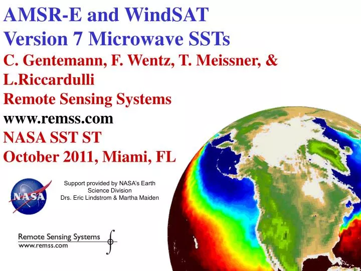
AMSR-E and WindSAT Version 7 Microwave SSTs C. Gentemann, F. Wentz, T. Meissner, & L.Riccardulli Remote Sensing Systems www.remss.com NASA SST ST October 2011, Miami, FL. Support provided by NASA’s Earth Science Division Drs. Eric Lindstrom & Martha Maiden. Version 7.

E N D
AMSR-E and WindSAT Version 7 Microwave SSTs C. Gentemann, F. Wentz, T. Meissner, & L.Riccardulli Remote Sensing Systems www.remss.com NASA SST ST October 2011, Miami, FL Support provided by NASA’s Earth Science Division Drs. Eric Lindstrom & Martha Maiden
Version 7 • All passive microwave data at RSS is being released as version 7 (SSMI, AMSRE, WindSAT, …) • All version 7 data have been calibrated in a consistent manner and are running version 7 RTM-derived algorithms Remote Sensing Systems www.remss.com
V7 Inter-calibration • A major objective of this investigation was to bring AMSR-E into the overall climate time series of ocean products from SSMI, TMI, WindSat, and SSMIS. • We have developed a unified method for intercalibration of all satellite microwave imagers. During the period from 2003 through 2007, we have simultaneous operation of F13/F14/F15 SSMI, F16 SSMIS, TMI, AMSR-E, and WindSat. • This is an ideal overlap period to do the necessary intercalibration. Because the various sensors operate at slightly different incidence angles and frequencies, one should not directly compare the observations and expect agreement. Rather than directly comparing the observations, we compare the difference between the observation and our radiative transfer model (RTM): TA = TA,mea – TA,rtm. By using TA, the effects of varying incidence angles and frequencies are eliminated. We use the same method to compute TA,rtm for all sensors.
AMSR-E 19GHz channel mis-specification • Difference AMSR-E TA measurement - simulated TA • All channels ~0K, except the except for the 18.7 GHz channel • Possible explainations: • the effective center frequency for this channel was slightly different than the 18.7 GHz nominal value. Changing the frequency to 18.64 GHz in the RTM removed the difference • strong non-linearity in this channel, but the required shape of the non-linearity would need to have strong 3rd order components (unlikely). • The one remaining explanation is the RTM is using the wrong water vapor absorption in the 19 GHz region. (would have shown similar problems with SSM/I, WindSAT)
V7 has improved geophysical retrievals – improved SST, more physically realistic dependence on wind speed • Better RFI flagging • RFI becoming an increasingly irritating problem
RFI • Increasingly irritating issue • Becoming a significant problem, especially in near-land regions • Ground-based & space-based sources • Most at 6 or 10 GHz • Our bandwidth much larger than protected spectrum
Upcoming sensors • Feb 2012 – AMSR2 • L1A available? • Format? L1B possible to reverse to L1A? • When to expect data? • 2014 GPM GMI • No SST plans so far. Probably best calibrated instrument launched so far. Diurnal precession allows cross-calibration with all other PMW instruments in orbit • MIS – • ?
Liege Colloquium http://modb.oce.ulg.ac.be/colloquium/ There are also many open research questions that need to be addressed, or that are being actively addressed by the scientific community, and that are of particular interest for the 2012 Liège Colloquium: International efforts are aimed to quantify and correct biases between different sensors, which is needed for assessing long-term trends and their effect on the climate. The development and improvement of techniques to merge data from different platforms and create homogeneous time series is also needed. New challenges appear with the regionalization of algorithms and their adaptation to coastal and closed domains. Uncertainty estimation needs to be assessed, and the retrieval algorithms need to be improved as we increase our knowledge of the ocean. The use of geostationary satellites allows for an estimation of the processes occurring at sub-diurnal scales, and specific algorithms for this type of platform may provide new opportunities, particularly for ocean colour.