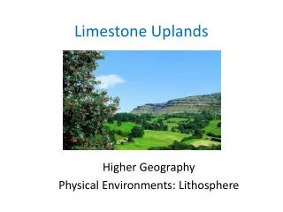
Limestone Uplands
Limestone Uplands. Higher Geography Physical Environments: Lithosphere. Limestone Uplands Outline. Characteristics and location of carboniferous limestone in the British Isles. Formation of limestone landforms on the surface. Formation of limestone landforms beneath the surface.

Limestone Uplands
E N D
Presentation Transcript
Limestone Uplands Higher Geography Physical Environments: Lithosphere
Limestone Uplands Outline • Characteristics and location of carboniferous limestone in the British Isles. • Formation of limestone landforms on the surface. • Formation of limestone landforms beneath the surface. • Identifying limestone landforms on O.S. Maps.
Aims of the lesson • To learn about the characteristics of carboniferous limestone and where it is found in the UK. • To be able to describe the formation of a limestone pavement using diagrams.
Limestone Limestone is a sedimentary rock. It is created when sediments containing large amounts of dead sea creatures are turned into rock. Contains large amounts of calcium carbonate (CaCO3).
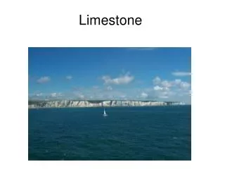
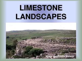
Karst Landscapes Carboniferous limestone creates distinctive landscapes called Karst. The main Karst areas of the British Isles are: • Midland Scotland • South Wales • Yorkshire Dales • The Burren, Ireland
Factors Influencing Karst Scenery • Rock Structure • the rock is divided into blocks as a result of breaks between the rock beds (bedding planes) and vertical cracks (joints). • Permeability • water passes easily through the rock by following the bedding planes and joints. • Carbonation & Solution joint bedding plane
Carbonation Limestone = Calcium Carbonate Rainwater = Carbonic Acid Carbonic Acid dissolves Calcium Carbonate This is called CARBONATION, a type of solution weathering. Or … H2O + CO2= H2CO3 CaCO3 + H2CO3 = Ca(HCO3)2 Calcium Carbonate Dilute Carbonic Acid Calcium Hydrogen Carbonate
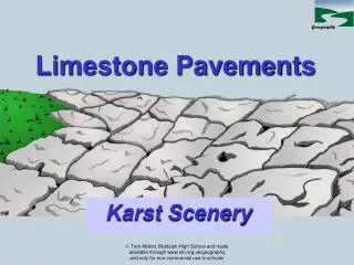
Limestone Pavement One of the most obvious features of an upland limestone landscape. Limestone is exposed to weathering by glacial erosion.
Diagram Memory Activity On the front desk is a series of diagrams showing the formation of a limestone feature. One person at a time from each group will come up to the front and study the diagrams. He/she will then report back to the group. By the end of the activity you should all have an exact copy of this diagram in your notes.
Limestone Pavements • Limestone is exposed to weathering by glacial erosion. • Carbonation and freeze thaw weathering exploit cracks in the rock called joints and bedding planes.
These gaps are widened until a series of rectangular blocks is created. This is the limestone pavement. The blocks are called clints and the joints are called grykes.
Clint Gryke Limestone Pavements Clint Gryke Clint Clint Gryke Clint
Summary So far we have learnt: • Limestone is a sedimentary rock that contains large amounts of calcium carbonate (CaCO3). • Carboniferous limestone forms karst landscapes in the British Isles e.g. Yorkshire Dales, The Burren, Brecon Beacons. • Limestone is made up of blocks separated by joints and bedding planes. • Limestone is permeable – water can pass through it. • Limestone is vulnerable to chemical weathering – carbonation. • A major surface karst landform is the limestone pavement e.g. Malham Cove.
Revision Question With the aid of annotated diagrams, explain the formation of a limestone pavement. (6 marks) Use you notes & p111 of the P&H Environments textbook to help you (diagram on p114). Tips: • Ensure you include a fully annotated diagram • Include the processes involved e.g. explain the process of carbonation and freeze-thaw. • Ensure your written answer is well structured and takes the reader through the formation process step by step. • Limestone exposed to surface by glacial erosion. • Structure of limestone. • Processes of chemical & physical weathering. • How is limestone changed? • Named example.
Sample Answer: Limestone Pavement Limestone pavements are a karstic landform made from carboniferous limestone. This sedimentary rock formed 350 million years ago and contains a high quantity of the calcium carbonate (1). A limestone pavement begins to form when a glacier erodes the topsoil and exposes the limestone beneath to the surface (1). At this point it is vulnerable to attack from both chemical and physical weathering processes. Weak carbonic acid is created when carbon dioxide mixes with water in clouds (1). This acid rain falls onto the limestone and exploits natural breaks in the rock called joints and bedding planes (1). Over time the acid rain dissolves the limestone and widens the gap between the joints (1). This process is called carbonation (1). Eventually the surface is divided into a series of rectangular blocks called clints separated by gaps called grykes (1). Freeze-thaw weathering can also contribute to the formation of this landform (1). Rainwater falls into the vertical joints and then freezes during cold nights (1). Once it freezes the water expands by 10% and exerts pressure on the sides of the rock, widening them over time (1). An example of this landform is Malham Cove in the Yorkshire Dales (1).
Sample Answer: Limestone Pavement Limestone pavements are a karstic landform made from carboniferous limestone. This sedimentary rock formed 350 million years ago and contains a high quantity of the calcium carbonate (1). A limestone pavement begins to form when a glacier erodes the topsoil and exposes the limestone beneath to the surface (1). At this point it is vulnerable to attack from both chemical and physical weathering processes. Weak carbonic acid is created when carbon dioxide mixes with water in clouds (1). This acid rain falls onto the limestone and exploits natural breaks in the rock called joints and bedding planes (1). Over time the acid rain dissolves the limestone and widens the gap between the joints (1). This process is called carbonation (1). Eventually the surface is divided into a series of rectangular blocks called clints separated by gaps called grykes (1). Freeze-thaw weathering can also contribute to the formation of this landform (1). Rainwater falls into the vertical joints and then freezes during cold nights (1). Once it freezes the water expands by 10% and exerts pressure on the sides of the rock, widening them over time (1). An example of this landform is Malham Cove in the Yorkshire Dales (1).
Mark Your Work Using the sample answer you have been given, mark your own work out of 6 marks. Any points you have not included should be added as bullet points beneath your original answer.
Aims of the lesson • We will be able to describe the formation of a shake hole. • We will be able to describe the formation of a potholeand give a named example.
Shakeholes A shakehole is a depression in the limestone landscape. In some limestone areas there is a covering of boulder clay about two or three metres thick. Shakeholes are formed where surface water washes the boulder clay away. They are usually found in groups.
Potholes (Sink Holes or Swallow Holes) Surface and rain water do not flow far on exposed limestone, but infiltrate rapidly into the rock and soil. A stream travelling over an impermeable rock will very quickly disappear when it has to travel over limestone. These potholescan be many metres deep leading down to a series of subsurface features. Pothole Formation
Review Questions • What is the difference between a shakehole and a sink hole? • What sort of type of material is found blocking a shakehole and how is it removed? • What is our named example of a pothole? • What factors could lead to a pothole growing in size?
Summary In this lesson we have: • Learnt that a shakehole is formed when boulder clay deposited in a limestone hollow (doline) is removed by rivers. • Learnt that a pothole is created by a river flowing over permeable limestone and flowing underground e.g. Gaping Gill.
Aims of the lesson To carry out your own research on the following landforms: • Shakeholes • Potholes • Scars & Scree Slopes • Dry Valley • Gorge Glaciokarstic Features
BBC Website Research Go to the following website: http://www.bbc.co.uk/scotland/education/int/geog/limestone/index.shtml Collect information in your notes on: • What is a glaciokarstic feature? • Shakeholes, Potholes, Scars & Scree Slopes, Dry Valley, Gorge. • How was the feature formed? • Named example of landforms.
Glaciokarstic Features That glaciokarstic landforms have been influenced by both limestone and glacial processes.
Scars & Scree Slopes During the last ice age huge ice sheets scraped away the soil covered spurs in many valleys in the Yorkshire Dales. Steep cliffs of bare rock were exposed. Because these scars are more liable to frost shattering and other forms of erosion they usually have scree slopes of broken rock below them.
Dry Valleys During the last ice age the limestone was frozen to great depths. When the ice melted it carved out valleys over the frozen rock. When the limestone thawed out the surface water was able to infiltrate down through the rocks and the dry valleys were left with no surface water.
Gorge During the meltwater phase of the last ice age, underground streams eroded vast caverns as huge volumes of water travelled through the limestone. Sometimes the roofs of these caverns can collapse exposing the "underground stream" in a very steep sided gorge
Summary So far we have learnt: • That glaciokarstic landforms have been influenced by both limestone and glacial processes. • Examples of glaciokarstic landforms: • Scars & Scree Slopes e.g. Twistleton Scar or Raven Scar • Dry Valley • Gorge Trow Gill Gorge
ODD ONE OUT Sedimentary Igneous Metamorphic Exfoliation Freeze-thaw Carbonation Soil Creep Rockfall Landslide Dry Valley Pothole Shakehole The Burren Yorkshire Dales Loch Lomond
Aims of the lesson • We will be able to describe the formation of a cavern. • We will be able to describe the formation of a stalactite, stalagmite and pillar.
Caverns & Caves River flows down pot-hole Joints & bedding planes close together. Water dissolves the rock.
Caverns & Caves Limestone dissolved by the water to form a cavern Stalactites Limestone Pillar Stalagmites
Cavern Formation River flows down pot-hole and works its way through the joints and bedding planes. This water is still acidic and so dissolves the limestone by carbonation. Where the joints and bedding planes are close together, the limestone may be completely worn away to form a cavern.
Sequencing Activity Read p113 of the P&H textbook. In your groups, read the statements on the next slide carefully. As a group try to decide what order you would put the cards into to describe the formation of stalactites, stalagmites & pillars.