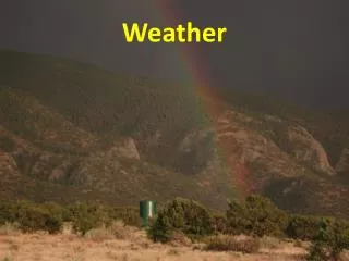
WEATHER
WEATHER. 6-4.4 Summarize the relationship of the movement of air masses, high and low pressure systems, and frontal boundaries to storms (including thunderstorms, hurricanes, and tornadoes) and other weather conditions. Interactions.

WEATHER
E N D
Presentation Transcript
WEATHER 6-4.4 Summarize the relationship of the movement of air masses, high and low pressure systems, and frontal boundaries to storms (including thunderstorms, hurricanes, and tornadoes) and other weather conditions.
Interactions • Interactions between air masses, fronts, and pressure systems result in various weather conditions.
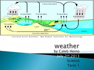
Air Masses • Huge bodies of air that form over water or land in tropical or polar regions. • Temperature and humidity conditions (for example, warm or cold air, humid or dry air) within the air masses as they form are important to the resulting weather conditions when air masses move.
FRONTS As these air masses move and collide with each other, fronts form at the boundaries between the air masses.
FRONTS • Depending upon the air masses involved, a warm front, cold front, stationary front, or occluded front can develop.
FRONTS • When a warm air mass collides and rides over a cold air mass, the resulting warm front may produce long periods of precipitation and warmer temperatures. • When a cold air mass collides and slides under a warm air mass, the resulting cold front may produce thunderstorms and sometimes tornadoes and cooler temperatures.
FRONTS • When neither a cold air mass nor a warm air mass moves at a frontal boundary, the resulting stationary front may produce long period of precipitation.
FRONTS • When a cold air mass pushes into a warm air mass that is behind a cool air mass, the warm air mass is pushed up above the cooler air masses. The resulting occluded front may produce long periods of precipitation.
HIGH AND LOW Pressure systems • Warm air rising or cold air sinking combined with the spinning of Earth causes the air to spin forming high and low pressure regions.
High and low Pressure systems • High pressure systems usually signal more fair weather with winds circulating around the system in a clockwise direction. • Low pressure systems with counterclockwise circulating winds often result in rainy and/or stormy weather conditions.
Storms • Severe weather conditions called storms occur when pressure differences cause rapid air movement. • Conditions that bring one kind of storm can also cause other kinds of storms in the same area.
thunderstorm • Thunderstorm is storm with thunder, lightning, heavy rains and strong winds; form within large cumulonimbus clouds; usually form along a cold front but can form within an air mass.
tornado • Tornado is a rapidly whirling, funnel-shaped cloud that extends down from a storm cloud; the very low pressure and strong winds can cause great damage to people and property; are likely to form within the frontal regions where strong thunderstorms are also present.
hurricane • Hurricane is a low pressure tropical storm that forms over warm ocean water; winds form a spinning circular pattern around the center, or eye, of the storm; the lower the air pressure at the center, the faster the winds blow toward the center of the storm.
Other Weather conditions • Since weather is a condition of Earth’s atmosphere at any time, weather conditions may include fair weather, showers or light rain, humid conditions, clear skies with cold conditions, days of clouds and precipitation, or others that do not necessarily involve storms.
6-4.5 Use appropriate instruments and tools to collect weather data (including wind speed and direction, air temperature, humidity, and air pressure). • 6-4.6 Predict weather conditions and patterns based on weather data collected from direct observations and measurements, weather maps, satellites, and radar.
Understand weather • In order to understand the conditions in weather systems and be able to make weather forecasts as precise as possible, weather data must be accurately collected.
Anemometer • A tool used to measure wind speed in miles per hour.
Wind vane • A tool used to measure wind direction. • Sometimes referred to as a wind-weather vane or a wind sock. • Wind direction is described by the direction from which the wind is blowing.
thermometer • A tool used to measure air temperature in degrees Fahrenheit or Celsius.
Sling psychrometor • A two-thermometer instrument also referred to as a wet-dry bulb used to measure relative humidity (the amount of water vapor in the air). • Temperatures readings are converted using a relative humidity table.
Barometer • A tool used to measure air pressure in inches of mercury or millibars (mb).
Rain gauge • A tool used for measuring the amount of precipitation in inches or centimeters.
Direct observation and measurements Direct Observations and Measurements • Basic weather conditions can be observed and/or measured or obtained from meteorologists at national weather data collection sites. • In order to make weather predictions, the data should be collected on a regular basis over a period of time.
Direct observation and measurements • This allows for the development of patterns in weather conditions from the analysis of the data. For example, a hurricane’s path can be predicted using data on its position over time (plotted on a hurricane tracking map), thereby allowing meteorologists to make predictions concerning the possible warnings to land areas in the hurricane’s path.
Weather Maps Weather maps • Weather maps can help predict weather patterns by indicating high or low pressure systems (isobars), movement of air masses and fronts, or temperature ranges (isotherms).
Station models Station models from specific locations provide information that can also be used to predict weather patterns. Information found on a station model can include cloud cover, • temperature (85°F), wind direction and speed, precipitation (* - snow,● – rain), or barometric pressure (1002 mb).
satellites Satellites • Satellite images are used for seeing cloud patterns and movements. • For example, hurricane clouds and movement can be observed using satellite images.
Radar • Radar images can be used to detect cloud cover, rainfall or storm location, intensity, and • movement, as well as the potential for severe weather (for example, hurricanes or tornadoes).