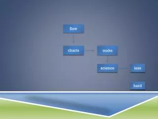
Flow
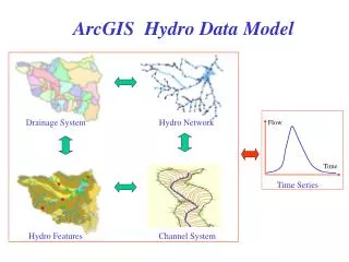
Drainage System. Hydro Network. Flow. Time. Time Series. Hydro Features. Channel System. ArcGIS Hydro Data Model. Drainage System. Hydro Network. Hydro Features. Channel System. HEC tools and ArcHydro. HEC-GeoHMS. CWMS. DSS. Flow. Time. Time Series. National Hydro Data.

Flow
E N D
Presentation Transcript
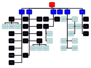
Drainage System Hydro Network Flow Time Time Series Hydro Features Channel System ArcGIS Hydro Data Model
Drainage System Hydro Network Hydro Features Channel System HEC tools and ArcHydro HEC-GeoHMS CWMS DSS Flow Time Time Series National Hydro Data HEC-GeoRAS
Bringing together these two communities by using a common geospatial data model http://www.crwr.utexas.edu/giswr CRWR GIS CRWR GIS in Water Resources Consortium Water Resources
Feb 1999 project initiated July 1999Consortium established August 1999kickoff meeting of Consortium Feb 2000 GIS in Water Resources Conference in Austin June 2000 First draft data model and book completed for GIS Hydro 2000 workshop in San Diego Dec 2000 NHD Applications Symposium in Austin Feb 2001 Arc Hydro design completed July 2001 Revised book to be completed for GIS Hydro 2001 workshop in San Diego Arc Hydro Milestones
Geodatabase Book Series Geodatabase models for application areas General Geodatabase in ArcInfo 8
CD-ROM at back of book ArcGIS Hydro UML diagrams, Repository, Example Geodatabases
ArcGIS Hydro Data Model Hydrology Hydrography
Geodatabase Feature Dataset Geometric Network Feature Class Object Class Relationship ArcGIS Hydro Implementation
GIS in Water Resources Consortium ArcGIS Hydro Data Model Feb 28, 2001 Hydro Features
GIS in Water Resources Consortium ArcGIS Hydro Data Model Feb 28, 2001 Hydro Network
GIS in Water Resources Consortium ArcGIS Hydro Data Model Feb28, 2001 Drainage
GIS in Water Resources Consortium ArcGIS Hydro Data Model Feb 28, 2001 Channels
GIS in Water Resources Consortium ArcGIS Hydro Data Model Feb 28, 2001 Time Series
National Hydro Data Programshttp://www.crwr.utexas.edu/giswr/nhdconf/nationalhydro.html National Elevation Dataset (NED) National Hydrography Dataset (NHD) NED-Hydrology Watershed Boundary Dataset
Watersheds of the US 8-digit HUC watersheds 2-digit water resource regions
Hydrologic Unit Code Watersheds ~ 2000 for US, about the size of counties
Watershed Hierarchy Digit # 2 4 6 8 HUC 10 12 NED-H Available In Progress
National Program by USGS and USDA (NRCS) Boundaries for 10- and 12- digit watersheds First cut is by automated delineation from NED Hand checked and edited Watershed Boundary Dataset 10-digit watersheds
National program by USGS and NWS 5000 cellthreshold on a 30m DEM (~ 8 km2 average drainage area) ~ 1 million catchments for US when completed Includes grid derived products e.g. topmodel index
River networks for 8-digit HUC watersheds
Lower West Fork, Trinity River Basin HUC = 12030102
NHD River Reaches 412 River Reaches In Upper West Fork
River Reach Codes Rch_Code = 12030102000151 Rch_Code = 12030102000005 Segment# HUC#
National Water Information System Web access to USGS water resources data in real time
National Hydro Data Programshttp://www.crwr.utexas.edu/giswr/nhdconf/nationalhydro.html National Elevation Dataset (NED) National Hydrography Dataset (NHD) NED-Hydrology Watershed Boundary Dataset
How do we combine these data? DEMs Watersheds Streams Waterbodies
Data Model Based on Inventory NHD Points NHD Lines Make an inventory of all features of a given type in the region NHD Areas Gages Dams What is it? Where is it? Bridges
Data Model Based on Behavior Follow a drop of water from where it falls on the land, to the stream, and all the way to the ocean.
Integrating Data Inventory using a Behavioral Model Relationships between objects linked by tracing path of water movement
Where Does the Raindrop Go? Dale Honeycutt’s concept, May 2000
Water Flows from an Area to a Line • Problems with this: • Areas and lines are not always consistent with one another. • Sometimes many lines within one area.
How to Connect Areas to Hydronetwork? Regardless of where the drop falls in the area, its runoff is on the network at the outlet point Areas connect to lines at points Outlet Points
Where Does the Raindrop Go? Drainage area and raindrop path Flow direction and DEM streams Watershed DEM
Watershed and Stream Reaches Catchments and Outlet Junctions Downstream trace HydroNetwork
Traces and Relationships Selected Catchments + Downstream trace Upstream Trace
Basins and Watersheds Watershed 1113030213 Upper Washita Basin (HUC8) 10-digit watersheds and outlets
Downstream Trace Watershed 1113030213 NHD for the Upper Washita
Scales of Analysis DEM for smaller areas (Up to 20 million cells) Network for larger areas