Download
1 / 22
220 likes | 332 Vues
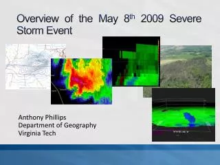
This report provides an in-depth analysis of the severe storm event that occurred on May 8, 2009, affecting Virginia and North Carolina. It highlights the characteristics of a mesocyclone, including radar observations and thermodynamic profiles, particularly near Marion, VA, and Alleghany County, NC. The findings reveal important insights into the storm's behavior, including significant shear and rotation, potential for tornado development, and implications for future storm warnings, emphasizing the correlation between mesocyclone strength and the likelihood of severe weather.

E N D
Overview of the May 8th 2009 Severe Storm Event Anthony Phillips Department of Geography Virginia Tech
Synopsis and ConclusionWhat was learned • Reports of straight-line wind damage in Marion, VA might easily have been tornado damage. The supercell had… • increasing reflectivities at all tilts, • a well-defined inflow notch and shallow v-notch, • strong low and mid-level circulation, • an overhanging weak echo region (WER), • and tightening of the mesocyclone as it passed near Marion.
Synopsis and ConclusionWhat was learned • From radar observations, the SPC meso analyses were correct in predicting the greatest amounts of shear to the north. • Strong updrafts and rotation reached over 20 kft near Marion. • Shear and rotation didn’t extend much above 10 kft with the Alleghany tornadoes.
Synopsis and ConclusionWhat was learned • A very good correlation exists between mesocyclone strength and tightening of rotation • Even though the storm weakened while crossing the high country, it regained strength quickly before tornadogenesis occurred (conservation of potential vorticity) • Consider extending Tornado Warnings even if the storm has weakened since: 1) it’s had a history of rotation, and 2) it may likely re-intensify.
Synopsis and ConclusionWhat was learned • Finally…storms could have been even more severe had additional CAPE been present. Questions?