Download
1 / 112
1.12k likes | 1.35k Vues
Explore China's geography, population characteristics, and the effects of its size and diversity. Discover how natural barriers shape China's demographics, economic activities, and cultural interactions.

E N D
Size in Comparison to the USA Population
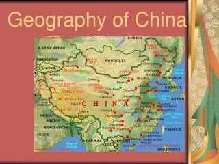
Comparing Size & Latitude Globalization & Diversity: Rowntree, Lewis, Price, Wyckoff
Population • China has more than 1.2 to 1.3 billion people, making it the most populous nation • The population density is over 110 people per square kilometer • 90% of China’s population lives on less than 40% of the land
Population • China is multi-ethnic: Han, Manchu, Mongol, Turkish, and Tibetan • The majority of ethnic minorities live in the northeast, northwest, and southwest • Mongols are one of the largest minority group in China • Made up of more than 50 ethnic groups • Speak several languages and dialects
Effects: China’sSize • Eventually, overcrowding and shortages of food and shelter will be major issues • Population Control Policies • Families can have no more than 1 child • One-couple, one-child policy – couples were given special rewards such as better housing and pay • Couples who didn’t follow faced fines and wage cuts • Results • Rural families rarely followed the policies • More children allowed more workers on the farm • Policies have slowed population growth • Tiananmen Square Massacre in 1989
Effects: Cities of China • China has more than 50 cities with populations of half a million or more • Coastal Shanghai is the largest city in China with a population of around 15 million
Effects: China’s Demographic Issues • The problems of controlling it... • The population exploded after 1949. • Population control was secondary. • Mao Zedong saw numbers as a workforce and a way to fight the Soviet Union and the United States. • Calls for women to “breed for the motherland”. • Population distribution • Excessive concentration: • 50% of the population lives on 8.2% of the land. • Bulk of the population along the coast. • East China accounts for 90% of the population. • 56%, about 728 million, are living in mountainous areas. • High density rural areas.
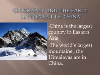
For thousands of years, the ancient Chinese thought they were pretty much alone on the planet, except for the barbarians to the north, the Mongols. China’s Geographic Barriers China’s natural barriers to the west, south, and east helped protect these early people from invasion.
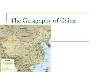
Geographic Barriers • Physical barriers in China cover 80% of the country • Gobi Desert • Mongolian and Tibetan Plateaus • Himalayan Mountains
Natural Borders and Barriers • The Gobi Desert in northern China separates the country from its neighbors. • Rugged mountains make up Western China. • Qinling Shandi, an important mountain range, separates N. China from S. China
China’s Geographic Barriers: Effects • ISOLATION • Natural protective barriers • Distance • Inward looking (central kingdom) with minor incidences of cultural diffusion • Effects of one ocean • A history of emperors who restricted use of the coastline, except in local circumstances • Today the ocean is playing a major role in the economic (and cultural) transformation of coastal China. Globalization & Diversity: Rowntree, Lewis, Price, Wyckoff
How was China isolated from other civilizations because of it’s geography? • The high Tibet-Qinghai Plateau made contact with lands to the southwest of China difficult • The dry Gobi & Taklimakan Deserts made contact with lands to the northwest of China difficult
China was protected & isolated from outsiders by deserts & the Himalayan Mountains and the Pacific Ocean to the east (Three natural barriers) The Chinese referred to themselves as the “Middle Kingdom” & rarely traded with outsiders. Why? Ethnocentrism?
Middle Kingdom and Geographic Barriers • What is the “Middle Kingdom?” • Geographic barriers like mountains and seas cut China off from other lands • They had no knowledge of other cultures like Greece, Rome, India, or Egypt • They thought that they were at the center of the world and called themselves the “Middle Kingdom”
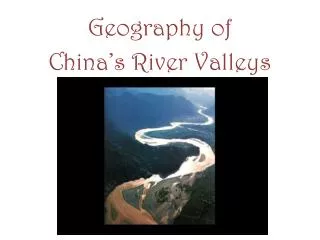
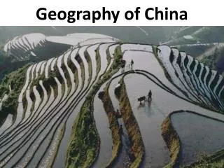
Rivers, Soils, Climates Loess • China’s first civilizations developed in river valleys • Two major rivers supplied water for the earliest civilizations • Chang Jiang, also called Yangzi • Huang He, or Yellow River • Both flow east from Plateau of Tibet to Yellow Sea • Annual floods deposited rich soil, loess, on flood plains • Valley of Huang He particularly fertile due to loess • Fine dusty soil • Carried into China by desert winds China’s Rivers The development of civilization in early China was aided by features like long rivers, fertile soils, temperate climates, and isolated valleys.
Impact of Rivers Crops • Most of eastern China covered with fertile soils; some regions better suited than others for growing certain crops • Southern China—warm, receives plenty of rainfall, excellent region for growing rice • Further north—climate cooler, drier; suitable for grains, wheat, millet Isolation • Combination of rivers for irrigation, fertile soil for planting allowed Chinese to thrive, as did China’s relative isolation • Mountains, hills, desert protected China from invasion • Himalaya Mountains separate southern China from India, rest of southern Asia; vast Gobi Desert prevented reaching China from west
The Rivers of China • China has three major rivers that begin in the Himalayas and flow into the East China Sea or Yellow Sea. Chinese Name River Huang He Yellow River Yangtze River Chang Jiang West River Xi Jiang
Impact of the Rivers on China’s History and Development • Early civilizations developed near rivers • China had a few rivers that provided resources to be successful • Chang Jiang River (longest river) • Huang He River • Yangzi River • China’s rivers overflowed just like others we have studied • Provides fertile soil for farming • The Huang He River is also known as the Yellow River because of the Loess • Loess is yellow-brown soil that the Yellow River carries along
China’s Rivers • 1- Huang He (Yellow River). • Can carry up to 40% sediment weight (highest in the world). • Subject to flooding, especially in its delta. • Changed course many times. • 2- Chang Jiang (Yangtze). • Longest river, China’s main street (6,300 km). • Flood of 1998 left 14 million homeless. • 3- Pearl River delta system • Most productive and sustainable ecosystem in the world. • Rice paddies and fish ponds. • 4- Heilong Jiang (Amur). • China's border with Russia. 4 1 2 3
River systems • Huang He (Yellow) -Named due to yellow • silt the river carries • Chang Jiang (Yangtze) • Longest river in Asia - Major trade route since ancient times • Xi Jiang (West River) • Runs in South China
China began along the Yellow (Huang He) & Yangtze Rivers in the North China Plain; Only 10% of China is suitable for farming The Yellow River flooding was unpredictable & was called “China’s Sorrow” because its floods often destroyed entire villages
Yellow or Huang He River (HWAHNG*HUH)
Yellow River • Second longest river in China • Runs 3395 miles long • Often called the cradle of Chinese civilization • Much of the lower reaches of the Yellow River are not navigable • The huge amount of silt the river carries is deposited in these lower regions raising its bed above ground level in the flat North China Plain.
Yellow River • Devastating floods • To reduce effects of flooding, have built earthen dikes or walls long the river to protect crops • Dikes slowed river’s flow and causes silt to deposit on bottom of river • Silt levels grew higher, so Chinese build higher walls • Chang Jung---an engineer in the 1st century BC proposed a solution to the flooding but everyone ignored him
Yellow River • Chinese kept building higher dikes to prevent flooding • Huang or Yellow River now flows 12 feet above the surrounding lands due to the dikes • Flooding still continues every few years when dikes break and crops are destroyed and many people die • Rainfall in the area is unpredictable and contributes to flooding
Yellow River • What is “China’s Sorrow?” • The river was unpredictable and dangerous and often kills thousands with floods • The river also brought life through fertile soil • Destructive floods would come without warning • To control the flooding the people built dikes or walls that hold back water
Huang He River (Yellow River)- China’s Sorrow Some 10 million people drowned or died of famine & disease as the result of the catastrophic floods (1887-1943).
Yellow River and Flooding Issues • Erosion on the Loess Plateau • Huang He’s sediment burden from the Loess Plateau • Loess – a fine, wind-blown deposited material • Light tan color accounts for the old name, Yellow river and Yellow Sea • Loess is fertile, but vulnerable to erosion when plowed • Loess Plateau - one of the poorest parts of China Globalization & Diversity: Rowntree, Lewis, Price, Wyckoff
Yangtze or Chang Jiang or Yangzi River (CHAHNG*JYAHNG)
Yangtze River Yangzi (Yangtze) River in Central China • China’s largest waterway, 3rd longest in the world • Flows for 3,434 miles (6,300 km) • The Chinese say, “if you haven’t traveled up the great Yangtze River, you haven’t been anywhere.” • Considered the lifeline of China • Cuts a deep channel in the valley • Large ships can navigate 600 miles up stream • Small ships can navigate 1,700 miles up stream
Yangtze River stretches through nine provinces. The city of Shanghai is known as the gateway to the Yangtze.
Yangtze River • Changjiang in Chinese • Means “long river” • Creates a basin of more than 2,000 miles from west to east and a basin of more than 600 miles from north to south • Drains into the South China Sea • Carries more water than any other river in China • The land area of Yangtze River valley is 19% of the total land in China. • The total population of Yangtze River valley is 358 million, nearly 35% of the national population (1983).
Yangtze River • Open to navigation all year round • Three Gorges is dangerous to navigate due to the currents and shallows…why they built the dam there • Feeds into Lake Dongting, the second largest lake in China • Eventually flows into the sea near China’s largest city of Shanghai
Many earn a living from fishing on the river. How will the dam affect them? About 350 million people live near the Yangtze River and its 700 tributaries. The lives of the people living near the Yangtze are affected in some way everyday by the river. Dangerous floods kill people and livestock living near the river.
This is what the Yangtze valley looks like at the moment River boat cruises, like this one, is way of life for many and is how they earn a living. What will happen to these people when the project is finished? Almost all of the boating traffic in China is on the Yangtze River.
North China Plain • Is in eastern China • Many people live there • It is the center of agriculture and industry • Much of China’s food is produced there • Lands on the plain have LOESS or yellow-brown soil that blows from the desert • Crops like soybeans, wheat, and cotton are grown on terraces or platforms of earth like stairs • Beijing, the capital of China, is on the plain
North China Plain • Flat region of grassland in Inner China • Climate is fairly mild • Warmer than the areas to the north and cooler than areas to the south • Sometimes called the “Land of Yellow Earth” due to the yellow limestone silt known as LOESS • Plains cover 12% of China, River basins cover 19%
Why did most early people settle on the North China Plain? • The Tibet-Qinghai Plateau and Northeastern Plain are too cold and dry for agriculture • The Northwestern Deserts are too dry for agriculture • The heavy rains of the Chang Jiang Basins may have made farming difficult • The North China Plain was ideal because it has water, fertile soil, and a moderate climate
What did the North China Plain offer to the early people that settled there? • Huang He (Yellow River) was a source of water for farming • Silt from the flooding of the river helped to fertilize the land
North China Plain • Flooding in Northern China • Northern China Plain has long been plagued with floods and droughts • Worst floods caused by Huang He (Yellow River) • Huang He carries a huge sediment load (suspended clay, silt, sand); is the world’s muddiest river • Many dikes, but it’s still “the river of China’s sorrow” Globalization & Diversity: Rowntree, Lewis, Price, Wyckoff