Download
1 / 56
560 likes | 817 Vues
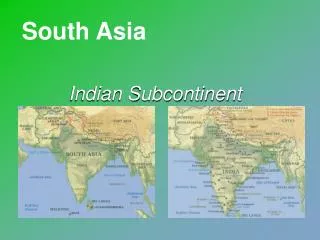
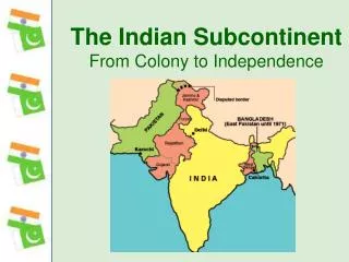
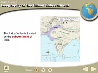
The Geography of the Indian subcontinent. Ms. Susan M. Pojer edited by Mrs. Browne Horace Greeley HS Chappaqua, NY. South Asia. Satellite View of South Asia. The Size of South Asia. Countries. Afghanistan. China. Iran. Bhutan. Nepal. Pakistan. Myanmar. India. Bangladesh.

E N D
The Geography of the Indian subcontinent Ms. Susan M. Pojer edited by Mrs. Browne Horace Greeley HS Chappaqua, NY
Countries Afghanistan China Iran Bhutan Nepal Pakistan Myanmar India Bangladesh Sri Lanka
cities Kabul Islamabad Kathmandu New Delhi Karachi
Topography of South Asia
Bodies of Water Indus R. Brahmaputra R. Ganges R. Bay ofBengal Arabian Sea Indian Ocean
River Systems • Three Major River Systems of South Asia • Ganges River ( in present day India) • Brahmaputra River (in present day Bangladesh) • Indus River (in present day Pakistan)
The Ganges River System 1,560 miles long
The Brahmaputra River System 1,800 miles long
The Indus River System 1,975 miles long
Valleys / Plains Indo-GangeticPlain
Mountains & Peaks Hindu Kush KhyberPassI I Mt. Everest▲ Himalayas Western Ghats
The Ghats • The Western Ghats are a UNESCO World Heritage Site as of 2006 • one of the world's ten "Hottest biodiversity hotspots" (Nature magazine) • over 5000 species of flowering plants • over 139 mammal species • over 508 bird species • over 179 amphibian species • & at least 325 globally threatened species live in the Western Ghats
The Khyber Pass • An important route that connects Pakistan and Afghanistan through the mountainous region • Concerns today re: use of the Khyber Pass by terrorist groups
The Himalayas • “him” [snow] • “aalaya” [home] • Mt. Everest is 29,035 feet. It is the highest mt. peak in the world.
2004 Earthquake In Indonesia:Tsunami Devastates Indian Ocean Coastlines!
the Tsunami’s Devestation 100,000s dead!
Deserts / Plateaus TibetanPlateau TharDesert DeccanPlateau
The Deccan Plateau • 31,800 square miles in size. • Elevation range: 2,000 – 8,000 feet high. • From the Sanskrit word, “dakshina” [“the south”].
The tibetan Plateau • The “Roof of the World.” • average elevation is 16,400 feet.
The Thar Desert • The Great Indian Desert • 200 - 1500 feet in elevation. • up to 127ºF in July.
Other Kashmir
Completed Map Hindu Kush KhyberPassI I TibetanPlateau Kashmir Mt. Everest▲ Indus R. Brahmaputra R. Himalayas Indo-GangeticPlain TharDesert Ganges R. Bay ofBengal DeccanPlateau Western Ghats Arabian Sea Indian Ocean
Climate of South Asia
Climate • Climate is varied and affected by mountain ranges in the region • India • Tropical wet and dry • Humid Sub-tropical • Pakistan & Afghanistan • Arid & Semi-arid • Bangladesh • Tropical wet
Monsoons • Summer Monsoons bring rain • Winter Monsoons bring dry air
Vegetation of South Asia
Demographic Data for South Asia