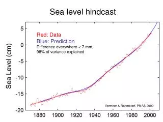
Sea level
Chiba University. North. North. North. Rakata. 0. 1. 2 km. Panjang. 1000m. Panjang island. Danan. Pre-historic Krakatau. Anak Krakatau island. 750m. Pre-historic Krakatau. Sertung island. Perbuwatan. Hal. Hal. Pf 1883. Pca1. 500m. Pca2. Lav 1972/1973. Pca2. Pf 1883. Smd.


Sea level
E N D
Presentation Transcript
Chiba University North North North Rakata 0 1 2 km Panjang 1000m Panjang island Danan Pre-historic Krakatau Anak Krakatau island 750m Pre-historic Krakatau Sertung island Perbuwatan Hal Hal Pf 1883 Pca1 500m Pca2 Lav 1972/1973 Pca2 Pf 1883 Smd 250m Sertung Sea level Sea level 0m D C 2000m 1000m Panjang island Pre-historic Krakatau 750m Anak Krakatau island Hal 1500m Pf 1883 500m Pca1 Pre-historic Krakatau Pca2 Lav 1972/1973 Pca2 Smd Rakata island 250m Sea level 1000m 0m Sertung island Bal E Hal 500m F Pre-1883 Krakatau Pf 1883 Pf 1883 Hal Sea level 0m A B Geologic Information Retrieving using Synthetic Aperture Radar The birth of Krakatau volcano complex Studi area map Retrieved Geologic Map of ancient Krakatau 60,000 years ago Sumatera island N Krakatau Volcano Complex Roc1 Lampung Lampung bay Legundi island Roc2 by Josaphat Tetuko Sri Sumantyo, Ph.D Rakata Sertung island Panjang island Panjang Rakata island Banten after gigantic eruption with the lost of volcano dome in 60,000 years ago Krakatau volcano complex 6o04’ caldera before 1883 Sunda strait Sertung island Roc1 Panaitan island Smd Sertung Java island Panjang island Rakata 0 15 km growing up of Rakata, Danan and Perbuwatan volcanoes 17th century 25 Roc2 Pf 1883 50 Panjang 25 Pf 1883 Danan 75 100 Anak Krakatau island Perbuwatan 50 125 F Smd 150 75 175 A Roc2 Smd Roc2 Smd sertung 100 Pca1 Hal Pca1 Pca2 north Hal Pca1 Hal Rakata, Danan and Perbuwatan volcanoes activities stopped in 1681. 6o06’ 25 Roc2 75 50 C 100 125 Roc2 25 125 100 200 50 Lav 1972/1973 D 75 E Smd Roc2 Lav 1979 Pca1 Hal Rakata Lav 1972 Hal Lav 1972/1973 paroxymal explotion of Danan and Perbuwatan volcanoes on August 27, 1883 Lav 1963 Panjang Smd caldera after 1883 Sertung Rakata Map legend Krakatau volcano complex growing slowly nowadays and always create spectacular history … Rakata island Hal 6o08’ Anak krakatau Panjang Lav Lavas were formed in 1963, 1972, 1975, 1980 Pca1 Pyroclastic airfall layer of ash, scoriaeous lapilli, sand and basaltic andesit bombs exposed in 1982. Bal Roc2 Pca2 Pyroclastic airfall layer of ash, scoreae, lapilli, sand and basaltic andesit bombs forming a younger active cinder- cone cindercone inside the old crater in October 1956. Sertung Smd Historic eruptions and recent activities Krakatau was well known and became famous in the world because of the paroxymal eruption on August 27, 1883 and it was considered to a great event of the eruptive history, which has erupted more than 18 cubic km of ash column of about 80 km high, and rose tsunami as high as 30 m along the west coast of Banten and south coast of Lampung. Although at that times the big cities have not developed as such today, but 295 small towns were swept by tsunami and killed 36, 417 people (Verbeek,1884), and the explosion could be heard at Africa, Australia, Philippine etc or 4800 km far away. Krakatau began to be known in the eruptive history when the gigantic eruption occurred in 416 BC, which caused a tsunami and formed a caldera (Judd, 1889). Furthermore De Neve (1981) noted some information that before the second paroxymal occurred in 1883, several large eruptions of Krakatau arose in the centuries of 3,9,10,11,12,14,16 and 17 which were followed by growing up of Rakata, Danan and Perbuwatan volcanoes. This volcanic activity stopped in 1681. After reposing of about 200 years, Krakatau began to indicate its activity which has preceded by the eruptions of Danan and Perbuwatan volcanoes. On May 20, 1883 the eruption of Perbuwatan volcano with basaltic composition, initiated a paroxymal explosion on August 27, 1883 (Neumann, 1951). Second repose period of Krakatau began in February 1884 to December 1927, when the first phase of eruption on December 29,1927 occurred as a submarine explosions in the center of Krakatau Volcanic Complex. The visible phenomena of the eruption comprised bublings and fountains of seawater (Stehn, 1929a). It was observed on January 20, 1929 the crater-rim appeared east of the eruption point, consisting of ashes, lapilli, loose block. It formed an island above the water and was named "Anak Krakatau" (Child of Krakatau). The eruptions continued until February 15, 1929 where the explosion column reached a height of 800 m. Observations on February 18, indicated that the eruption was no longer visible and the Anak Krakatau island was shaped like a sickle, opening to the south west, and which had reached a height of 38 m above sea level. This event was declared by Stehn as a birthday of Anak Krakatau. Growth and evolution of Anak Krakatau since its birth has been well recorded by many scientists. The last growth in 1996 was estimated about 200 m above sea level, and the area extent more than 200,000 square m which has been developed by lava flows during the four years activity. (Article source: Directorate of Volcanology and Geological Hazard Mitigation, ESDM, Indonesia and Krakatoa by Simon Winchester) 800 Smd Smd Material deposit of the rock such as silt, sand or block size, andesites, basaltic andesite, and obsidian fragments 700 650 600 450 550 500 400 225 275 350 250 300 Hal Hyperstene augite andesite lava flow and silica. 200 175 150 Pf 1883 Pyroclastic flow, intercalated by airfall deposit, surge 125 100 Bal Basaltic lava 75 Smd 50 25 Roc1 Rock distribution B 6o10’ Roc2 Estimated rock distribution Roc2 Validation : ESDM Krakatau Volcano Complex map and maps in Krakatoa by Simon Winchester Pf 1883 105o24’ 105o28’ 105o26’ 105o22’ Sertung island Panjang island Panjang island Sertung island Anak Krakatau island Anak Krakatau island Contact person : Josaphat Tetuko Sri Sumantyo, Ph.D Center for Environmental Remote Sensing Chiba University 1-33, Yayoi, Inage, Chiba 263-8522 Japan Tel. +81 (0)43 290 3840 Fax +81 (0)43 290 3857 Email jtetukoss@faculty.chiba-u.jp http://www2.cr.chiba-u.jp/lab/jtetukoss/ Rakata island Rakata island JERS-1 SAR 19980731 Landsat TM 19920518