Understanding Sea-Level Changes: Processes and Impacts
Explore the concepts of mean sea level, global geoid model, plate tectonics, and glacial cycles impacting sea levels over millions of years. Learn about eustatic and relative sea-level changes, with key take-home points and tools for studying sea-level changes. Visit the provided link for further reading.

Understanding Sea-Level Changes: Processes and Impacts
E N D
Presentation Transcript
Learning Objectives • The shape of the planet: difference between Geoid and Ellipsoid • The concept of Mean Sea Level • Article: http://www.esri.com/news/arcuser/0703/geoid1of3.html • Processes that control the Mean Sea Level and its changes • Sea level changes over millions of year • Sea level changes over the recent geologic past
What does it mean to be at an altitude of 4000 m? It means that I am 4000 m above the Mean Sea Level (MSL)
Model of the shape of the Earth geoid: The equipotential surface of the Earth's gravity field which best fits, in a least squares sense, global mean sea level (MSL) http://www.ngs.noaa.gov/GEOID/geoid_def.html
by definition: • Mean Sea Level = 0 m = equilibrium level • Changes in volume of water • Changes in shape and volume of ocean basins • Changes are measured as relative changes to a reference datum • This reference datum can be a fixed one (e.g. distance from the center of the earth) or local (coastline).
A change in volume of seawater in one ocean will affect the level in all others. Any such world-wide change in sea-level is called EUSTATIC SEA-LEVEL change A change in local sea level measured with respect to a land reference point is referred to as a RELATIVE SEA-LEVEL change
Other effects of plate tectonics e.g. Upper Cretaceous (90 Ma) MSL > 300 m
Summary of spatial-temporal scale of processes contributing to Mean Sea Level (D) Plate Tectonics 100 m (C) Melting of ICE Load from ice sheets deforms crust • Thickness and area of • continental crust • Thermal state (age) of crust • sediment loading MSL (meters) 10 m (A) Exchange of water with continents (Groundwater, Lakes, etc.) (B) Temperature expansion 1 m NOTE: A,B,C change in volume of water D change in shape of container 1 cm 1000 100 Ka 10 Ma 100 Ma 1 day 100 TIME (years)
Other processes complicating the study of mean sea level (ice or sediment loads) The concept of Post Glacial Rebound (PGR) !!!
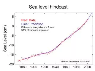
Last Glacial Maximum: 20 thousand years ago Laurentide Ice Sheet, 3-4km thick All this ice caused a EUSTATIC sea level drop of 125m How do we know this?
Aerial view of glaciated Bylot Island, Canada U-shaped valley Glacial Striations Glacial Flow
Date coral samples from various paleo-sea levels. Barbados is the “dipstick” for eustatic sea level reconstruction Now what?
Corals for paleo-sea level reconstruction From corals we know that LGM sea level was -125m
The subsidence of the Northern Sea (associated with relaxation from glacial loading) Rate of change in Sea Level mm/year Scandinavia Northern Sea Great Britain
Geological proxy for sea level change: 18O/16O in foraminifera Oxygen has two stable isotopes: 16O (99.8%) and 18O (0.2%) Rainfall and Ice are very depleted in 18O (lots more 16O) So when you build ice sheets, ocean loses 16O, becomes 18O-rich Forams record ocean 18O/16O ratio in shells 21,000 ybp
Take-home points: • eustatic vs. local sea level • lots of new, young, hot crust means higher sea level; • tectonic changes on 10-100Ma timescales Wilson cycle • glacial cycles have several impacts on sea level: • 1) ice sheets remove water lower sea level • 2) glacial loading/unloading reshapes crust under • and surrounding ice sheets • - changes occur on 10-100ky timescales • tools for studying sea level change through geologic time: • 1) radiocarbon-date marine shells & corals found at • known elevation (above MSL) and depth (below MSL) • 2) deep-sea sediment 18O record