Download
1 / 32
320 likes | 443 Vues
Sea Level and Climate Changes on NJ’s Continental Shelf. Dr. Michael J Passow.

E N D
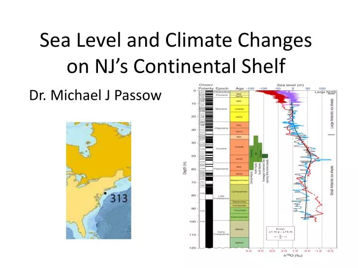
Sea Level and Climate Changeson NJ’s Continental Shelf Dr. Michael J Passow
Like a fiddler on the roof, it may seem strange to look at layers of underwater sediments and sedimentary rocks off the coast of New Jersey to discover how sea level and climate has changed over the past 35+ million years But that’s what today’s program is about
Where the ocean meets the land is not the real edge of continents • Oceans cover parts of what once was land, and, in some places, what is now land was once part of the oceans • The zone where continents and oceans meet is called the continental margin
Active Margins • Some coasts are geologically active • Many of these have deep trenches or are seismically active (have many earthquakes) • The west coasts of North and South America, from Tierra del Fuego to the Aleutians, are active margins http://en.wikipedia.org/wiki/Active_margin
Passive Margins • Other coasts show little geologic activity and are called passive margins Much of the East Coast of North America, from NJ to FL and continuing along the Gulf Coast to TX, is a passive margin
Active margins Passive margins are much wider have few earthquakes and no trenches along the Atlantic and Indian coastlines often have coastal plains and continental shelves the world’s great rivers drain across passive margins (Amazon, Nile, Congo, etc.) • are relatively narrow • have many earthquakes • drop off into deep trenches or have volcano chains • form the “Pacific Ring of Fire” that extends from New Zealand through the Philippines, Japan, Alaska, the Cascades, Middle America Trench, and Peru-Chile Trench
Profile of a Passive Margin Passive margins often have relatively flat continental shelves, steeper continental slopes, and continental rises that gradually blend into flat abyssal plains
The NJ continental shelf is about 120 km (75 mi) wide. At the shelf break, it is only about 200 m deep. http://clasticdetritus.com/2007/12/02/sea-floor-sunday-6-hudson-shelf-valley/
The Hudson Canyon • “underwater Grand Canyon” • More than 700 km long • As much as 12 km wide • Descends from about 100 m to more than 2,200 m below sea level • http://en.wikipedia.org/wiki/Hudson_Canyon
Other Submarine Canyonshttp://en.wikipedia.org/wiki/Submarine_canyon • West Coast canyons start very close to CA beaches and descend rapidly
Although “passive,” the NJ Conshelf records many changes • During glaciations, more is exposed land • Evidence of forests in what is now the sea—mastodont teeth snared in trawler nets • Outwash and other glacial features now features of sea floor • When sea level is higher, locations now on land submerge • Potential for significant changes over next century • Re-working of sediments during major storms, including Sandy
Rutgers University Research about the NJ Continental Shelf • IODP Expedition 313 (2009) • Objectives included learning about changes in sea level over past 35 million years, and climate changes during this period http://www.eso.ecord.org/expeditions/313/313.php
How Did We Get to the Ability to Conduct Such Research • It all began with Marco Polo in 1300 People began to sail in search of the wealth of the Orient, rather than merely go in caravans • Great coastal kingdoms of West and East Africa
In 1400 and 92…. • Columbus accidentally discovered the “New World” • Western European countries “claimed” vast territories for their empires
“Pioneers” of the 18th & 19th Century • Capt. James Cook’s HMS Resolution (1770s) • Charles Darwin and HMS Beagle (1830) • HMS Erebus and HMS Terror (1840s) • Focus on discovery and mapping
Matthew Fontaine Maury • Produced “The Physical Geography of the Sea” (1855) • Collected data from ship logs, collated into one of the most useful publications ever • First book to provide navigators with information about the oceans
Invention of the Telegraph Opened New Demands for Rapid Communication • Transcontinental, then, transAtlantic • “Great Eastern” (1869) http://raoulpop.files.wordpress.com/2009/02/1858-telegraph-cable-map1.jpg
New Need to Understand the Features Beneath the Ocean Waves • “HMS Challenger” (1872 – 1876) • Used weighted piano wire, rather than ropes • Discovered great trenches, flat plains, large mountains http://life.bio.sunysb.edu/marinebio/ch_01.jpg
SONAR • 1920s – “Meteor” first research ship to useSOundNAvigation andRanging devices • Extensive anti-sub warfare in WW II • Created vast archiveof echo-soundings
Bruce Heezen, Marie Tharp, and Physiographic Maps of the Sea Floor http://www.roebuckclasses.com/maps/physicmap/ocean/MapBBFull.jpg
Earlier Studies • Veitch & Smith (? 1939) • Early Lamont Geological Observatory research tested technology to probe beneath the sea floor • Many short cruises in NY Bight
Calypso (Jacques Cousteau, 1940s-80s)SCUBA,underwater living experiments, popular TV specials http://www.cousteau.org/about-us/vessels
Wood Hole Oceanographic Institution (WHOI) • R/V Atlantis and “Alvin” • R/V Knorr http://www.whoi.edu/page.do?pid=7121
Scripps Institution of Oceanography, UCSD • R/V Roger Reveille • R/V Melville http://shipsked.ucsd.edu/Ships/
NOAA and US Navy Research Vessels • Ronald Brown • Bruce C. Heezen • Ka'imimoana
Scientific Ocean Drilling • First proposed in 1957 by Walter Munk (SIO) • Exploratory drilling in early 1960 proved the feasibility of the technology • “Glomar Challenger” built in 1967 for the Deep Sea Drilling Project (DSDP)
Confirmation of the Seafloor Spreading Hypothesis • Almost as soon as the “Glomar Challenger” began its scientific drilling efforts, spectacular results were obtained! • During Leg 3 (1968), a series of cores confirmed that the age of the ocean floor varied, becoming progressively older on opposite sides of the mid-ocean ridgehttp://www.oceanleadership.org/classroom/plate_tectonics_nannofossils
ODP: Ocean Drilling Project1983 - 2003 • DSDP expanded and evolved into the ODP • “JOIDES Resolution” • More about the ODP can be found at http://www-odp.tamu.edu/index.html
IODP: Integrated Ocean Drilling Program2003 - 2013 • International marine research program that explores the Earth's history and structure as recorded in seafloor sediments and rocks, and monitors subsea floor environments. • Greatly expands the reach of these previous programs by using multiple drilling platforms, including riser, riserless, and mission-specific, to achieve its scientific goals.
IODP Also Uses Riser and Mission-Specific Drilling Vessels Riser vessel: “Chikyu” Mission-Specific Platforms http://www.iodp.org/mission-specific-platforms/ http://www.iodp.org/riser-vessel/
Expedition 313 Shallow-water drilling of the New Jersey continental shelf: global sea level and architecture of passive margin sediments http://www.eso.ecord.org/expeditions/313/313.php