Download
1 / 26
260 likes | 283 Vues
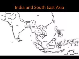
India and South Asia A little Geography and a few questions you will see on test. Landforms. South Asia’s landforms affect where people live and influence seasonal rain patterns. Northern landforms:. Himalaya Mountains Hindu Kush range Khyber Pass.

E N D
India and South AsiaA little Geography and a few questions you will see on test
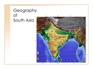
Landforms South Asia’s landforms affect where people live and influence seasonal rain patterns. • Northern landforms: • Himalaya Mountains • Hindu Kush range • Khyber Pass The Himalayan separate the Indian subcontinent from the rest of Asia.
Random but relevant Hindus believe that after death, a. a person’s spirit ceases to exist. b. each person will be offered the chance to enter nirvana. c. people join many gods and goddesses. d. most people are reborn as another living being.
The theory of continental drift, is generally the idea that scientist explain how the Himalaya’s were formed Sri Lanka teardrop-shaped island that broke away from the original Indian landmass
Located in the Himalaya, Mount ____________________ is the world’s tallest peak
The eastern and western Ghats block rainfall to the What? Deccan Plateau
Question India opened its economy to foreign investment in the a. 1940s. c. 1980s. b. 1960s. d. 1990s.
Question Which of the following is located between the Eastern and Western Ghats? a. Chota Nagpur Plateau c. Sri Lanka b. Deccan Plateau d.Khyber Pass
Water Systems South Asia’s major river systems bring fertile soil to the floodplains, serve as transportation routes, and provide hydroelectricity. • Three major river systems: • Ganges—most important river in South Asia • Indus
Water Systems Himalaya source for the Ganges, Brahmaputra, and Indus Rivers.
Water Systems Indus River flows mainly through Pakistan. Remember until independence Pakistan was part of India!
Question Where is the source for the Ganges, Brahmaputra, and Indus Rivers? a. Hindu Kush c. Himalaya b. the Arabian Sea d. the Indian Ocean
Natural Resources South Asia has a variety of natural resources upon which large populations are dependent for their livelihoods. • Hydroelectric power • Fish • Mineral resources • Drinking water • Alluvial soil • Transportation
Random but relevant How much of the world’s population lives in India? a. about 5 percent b. about 10 percent c. more than 15 percent d. more than 20 percent
Cultural Hearths--- started on river systems with a wealth of natural resources
Seasonal Weather Patterns Seasonal weather patterns bring much-needed rainfall to South Asia, but monsoon winds, as well as other natural disasters, can also bring devastating hardships.
Question Cyclones are the same as ____________________ in the Atlantic Ocean. a. tsunamis c. earthquakes b. hurricanes d. tornadoes
Seasonal Weather Patterns (cont.) • These seasons depend on seasonal winds called monsoons. • Temperature and rainfall impact agriculture in the region. • Factors: • Extreme heat • Monsoon winds
Random but relevant Which of the following actions helped to grow the Indian economy in the 1990s? a. deregulation and private ownership of businesses b. closing off foreign investment c. implementing a command economy d. high tariffs on foreign goods
Seasonal Weather Patterns (cont.) • Natural disasters: • Flooding from monsoon rains • Cyclones • Earthquakes • Tsunamis
Random but relevant The British employed a policy of ______________—an economic system of using colonies for supplying materials and markets to the colonizing country—in India. a. mercantilism b. imperialism c. market economy d. mixed economy
Review Economics terms gross domestic product (GDP) gross national product (GNP) the dollar value of all final goods, services, and structures produced in one year with labor and property owned by a country’s residents • dollar amount of all final goods and services produced within a country's borders in a year
Random but relevant Portuguese, Dutch, and British colonial powers fought for control over __________ because of its strategic trade route location. a. Sri Lanka b. Maldives c. Bangladesh d. Pakistan