Download
1 / 18
190 likes | 428 Vues
Earth Science: Unit 2 Review Sculpting E arth’s Surface. Unit 2 Review: Sculpting Earth’s Surface Chapter 5: Weathering, Soil, M ass Movements Chapter 6: Running Water and Groundwater Chapter 7: Glaciers, Deserts, and Wind. Earth Science: Unit 2 Review Sculpting E arth’s Surface.

E N D
Earth Science: Unit 2 Review Sculpting Earth’s Surface Unit 2 Review: Sculpting Earth’s Surface Chapter 5: Weathering, Soil, Mass Movements Chapter 6: Running Water and Groundwater Chapter 7: Glaciers, Deserts, and Wind
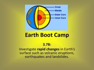
Earth Science: Unit 2 Review Sculpting Earth’s Surface • Mechanical weathering occurs when physical forces break rock into smaller and smaller pieces without changing the rock’s mineral composition • In nature, three physical processes are specifically important causes of mechanical weathering: frost wedging, unloading, and biological activity. • Chemical weatheringis the transformation of rock into one or more new components. • Two factors that affect the rate of weathering are rock characteristics and climate
Earth Science: Unit 2 Review Sculpting Earth’s Surface • Soilis the part of the regolith that supports the growth of plants. • Soil has four major components: mineral matter (broken down rock), organic matter or humus (decayed plant material), water and air. • The most important factors in soil formation are parent material, time, climate, organisms, and slope. • Soil varies in composition, texture structure, and color at different depths. Three common types of soil are pedalfer, pedocal, and laterite. • Human activities that remove natural vegetation, such as farming, logging and construction, have greatly accelerated erosion.
Earth Science: Unit 2 Review Sculpting Earth’s Surface • The transfer of rock and soil downslope due to gravity is called mass movement • Among the factors that commonly trigger mass movements are saturation of surface materials with water, oversteepening of slopes, removal of vegetation, and earthquakes. • Geologists classify mass movements based on the kind of material that moves, how it moves, and the speed of movement. • Water constantly moves among the oceans, the atmosphere, the solid Earth, and the biosphere. This unending circulation of Earth’s water supply is the Water Cycle.
Earth Science: Unit 2 Review Sculpting Earth’s Surface • Balance in the water cycle means the average annual precipitation over Earth equals the amount of water that evaporates. • The ability of a stream to erode and transport materials depends largely upon it’s velocity. • While gradient decreases between a stream’s headwaters and mouth,discharge increases. • Base level is the lowest point to which a stream can erode its channel.
Earth Science: Unit 2 Review Sculpting Earth’s Surface • Streams generally erode their channels by dissolving soluble material, by lifting loose particles, and by abrasion or grinding. • Streams transport their load of sediment in three ways: • (1) in solution (dissolved load) • (2) in suspension (suspended load) • (3) scooting or rolling along the bottom (bed load) • Deposition occurs as streamflow drops below critical settling velocity of a certain type of particle size • There are two general types of stream valleys: narrow V-shaped valleys and wide valleys with flat floors. • Most floods are caused by rapid spring snow melt and storms that bring heavy rains over a large region. • Measures to control flooding include the construction of artificial levees, building flood control dams, and placing limits on floodplain development. • A drainage basin is the land that contributes water to a stream.
Earth Science: Unit 2 Review Sculpting Earth’s Surface • Much of the water in soil seeps downward until it reaches the zone of saturation. The zone of saturation is where water fills all of the open spaces in sediment and rock. Groundwateris the water within this zone. • Groundwater moves by twisting and turning through interconnected small openings. The groundwater moves more slowlywhen the pore spaces are smaller. • A springforms whenever the water table intersects the ground surface. • Overuse and contamination threatens groundwater supplies in some areas. • Erosionforms most cavernsat or below the water table in the zone of saturation. • Karst areas typically have irregular terrain, with many depressions called sinkholes.
Earth Science: Unit 2 Review Sculpting Earth’s Surface • A glacier is a thick ice mass that moves slowly over the land surface. • Glaciers originate on land in places where more snow falls each winter than melts in summer. • The snowline is the lowest elevation in an area that remains covered in snow all year. • Glaciers are also important agents of erosion. Like rivers, they accumulate, transport, and deposit sediment. Unlike mountain streams, mountain glaciers advance only a few millimeters to meters a day. • A valley glacier is a stream of ice that flows between steep rock walls from a place near the top of a mountain valley. • Ice sheets are enormous ice masses that flow in all directions from one or more centers; much larger than glaciers. The only present day ice sheets are those covering Antarctica and Greenland • The Antarctic ice cap holds 80% of the world’s ice and nearly two thirds of the world’s fresh water.
Earth Science: Unit 2 Review Sculpting Earth’s Surface • The movement of glaciers is referred to as flow. • Glacial flow happens in two ways: • Plastic flow • Basal slip • Plastic flow involves movement within the ice • Basal slip is when the entire ice mass actually slips downhill due to gravity. The layers closest to the surface move faster than the layers closer to the top. • The uppermost zone that does not have plasticity is brittle. We call this zone thezone of fracture. • The zone of fracture experiences tension when the glacier moves. This tension results in deep cracks calledcrevices. • In the zone of accumulation; above the snowline, the glacier gains ice and forces movement downslope. • The area of the glacier below the snowline is where the glacier melts, losing ice and mass. We call this area of glacial melting the zone of wastage.
Earth Science: Unit 2 Review Sculpting Earth’s Surface • Glaciers lose ice when large pieces break off their front edge in a process called calving. • Calving creates icebergs when glaciers meet the ocean. • The glacial budget is the balance between the amount of snow-ice accumulated at the top of the glacier and the amount of loss at the glacier’s foot. • If more ice forms at the top of the glacier than melts at the bottom, than the glacier advances. • If the ice melts faster at the bottom than the glacier accumulates at the top, than the glacier retreats. • Glaciers erode the land in two ways: Plucking and Abrasion • Pluckingoccurs when rocks are broken loose from under the glacier. As the glacier flows, it loosens and lifts the rocks and carries them with the ice flow, plucking them from the Earth. • In abrasion, the load of rock and ice combined acts like sandpaper as it slides over the surface.This leaves telltale lines going in one direction showing the direction of ice flow. These marks are called glacial striations.
Earth Science: Unit 2 Review Sculpting Earth’s Surface Glaciers are responsible for a variety of erosional landscape features. Among these are • Glacial troughs: When a glacier moves through a mountain valley, it widens, deepens, and straightens this valley. The once V shaped valley becomes a U shaped glacial trough. • Hanging Valleys: Main glaciers cut deep U shaped valleys that are deeper than the those carved by smaller side glaciers that feed into the main glacier. • Cirqueis a bowl shaped depression at the head of a glacial valley that is surrounded on three sides by steep rock walls. • Arêtesare snaking, sharp-edged ridges produced when cirques form on either side of a divide • Hornsarepyramid shaped peaks produced when several cirques surround a mountain. • The term glacial drift is used to include all sediments of glacial origin. There are two types of glacial drift: • Tillis material deposited directly by the glacier, deposited as the glacier melts and drops it’s load of rock debris. • Stratified drift is sediment laid down by glacial melting water. Stratified drift contains particles that are sorted by size and weight of the debris. Some deposits of debris come from streams coming directly from the glacier. Stratified drift often consists of sand and gravel
Earth Science: Unit 2 Review Sculpting Earth’s Surface • Glaciers are responsible for a variety of depositional features including: • Lateral moraines are ridges that form along the sides of glacial valleys when the glaciers melt and leave the material it has gathered. • End Morainesform when glaciers stay stationary for long periods of time. Within the glacier, the ice still flows. This flow still carries rock debris to the foot of the glacier like a conveyer belt. Here the debris builds up and produces End Moraines. • Ground moraines form when glaciers begin to recede. The glacier front continues to deliver debris with the ice movement but instead of creating a ridge (as in the end moraine) the retreating foot of the glacier deposits the debris as a rock strewn plain. • Terminal Moraines: Glaciers can periodically retreat and than find balance again and remain stationary for a long time period. A glacier will form an end moraine when stationary than create ground moraines in it’s periods of retreat. This pattern can repeat many times before the glacier completely melts. • The farthest end moraine created in this pattern of stopping and retreating is called theterminal moraine.
Earth Science: Unit 2 Review Sculpting Earth’s Surface • Glaciers are also responsible for : • Kettles: Ponds and small lakes called kettles. Kettlesform when blocks of stagnant ice become buried in drift and eventually melt. • Drumlins are long elongated hills composed of glacial till. The steep side of the hill faces the direction the glacier came from and the gentle slope side the direction the ice moved toward. • Eskers are snakelike ridges composed of sand and gravel that were deposited by streams once flowing in tunnels beneath glaciers. • The ice sheets greatly affected the drainage patterns of major rivers in North America. Before the glaciers: • The Missouri River flowed north toward Hudson Bay • The Mississippi flowed through central Illinois • The Great lakes did not exist
Earth Science: Unit 2 Review Sculpting Earth’s Surface • Desert landscapes also reveal the affects of running water and wind. These combine in many ways to provide a wide variety of desert landscapes. • Deserts are very different than landscape is in humid areas of the world. Deserts generally have angular rocks, sheer canyon walls, and surfaces covered in sand and small pebbles. In desert areas, much of the debris of rock is from mechanical weathering. The minerals that make up the rock debris are unchanged chemically. • Chemical weathering is not entirely absent from a desert however. Over long spans of time, clays and thin soils do form. Many of the iron-rich silicate minerals oxidizeproducing rich rust colors in the landscape. • In humid or temperate climates, streams that run year round are a normal fixture. In contrast, in deserts many streams are “ephemeral” lasting only a short time. They run usually only after a rare heavy rain washes over the landscape. We call these ephemeral streams. • Because arid regions lack permanent streams, they have interior drainage. This means these temporary streams do not flow out to the ocean but end within the desert itself
Earth Science: Unit 2 Review Sculpting Earth’s Surface • Wind can still be an important force however and contributes to shaping the landscape. In deserts, the soil is dry and dusty and there are few plants with roots to hold the soil together. • Strong desert winds also pick up, move and deposit sediment in great quantities. These are known as dust storms. In the mid 30s, over-farming and drought destroyed much of the Midwest. With all the vegetation removed to grow crops; the area became a Dust Bowl when the strong winds picked up the soil and blew it in huge dust storms. • Winds erode in the desert through two ways • Deflationis the lifting and removal of loose particles of clay and silt. Courser sand particles roll or skip along the surface in a process called saltation. These larger sand particles make up the “bed load” much as they do in a stream, rolling along the bottom. • Abrasionis when wind-blown sand cuts and polishes exposed rock surfaces. Blowing sand can grind away at boulders and smaller rocks, sometimes sandblasting them into odd shapes.
Earth Science: Unit 2 Review Sculpting Earth’s Surface • Loessis windblown silt that blankets the landscape. Dust storms pick up this material, transport it and deposit it. The thickest and most extensive deposits of loess are in China. • Like running water, wind releases it’s load of sediment when it’s velocity falls and the energy available for transport diminishes. Sand begins to accumulate whenever an obstruction crosses it’s path and the wind diminishes. • Unlike deposits of loess, which forms blanket-like layers over broad areas, winds commonly deposit sand in mounds or ridges called dunes. • As sand is deposited on the sheltered side of the dune, it forms layers inclined in the direction the wind blows. These sloping layers are called cross-beds.
Earth Science: Unit 2 Review Sculpting Earth’s Surface • Sand Dunes are not random. They occur in a variety of consistent shapes. There are six major types of sand dunes • Barchan Dunes: Solitary sand dunes shaped like crescents are called barchan dunes. • Transverse Dunes: If prevailing winds are steady, sand is plentiful, and vegetation is sparse, dunes form in a series of long ridges. These are called transverse dunes because the ridges are perpendicular to the direction of the wind. • Barchanoid Dunes: A common dune form that is between a barchan and transverse dune is the barchanoid dune. These scalloped rows of sand form at right angles to the wind. • Longitudinal Dunes are long ridges of sand that form parallel to the prevailing wind. These dunes occur where sand supplies are moderate and the prevailing wind direction varies slightly. • Parabolic Dunes: Parabolic duneslook like backwards barchans. Their tips point into the wind instead of away from it. • Star Dunes: Star dunes are isolated hills of sand mostly found in parts of the Sahara and Arabian deserts. Their bases resemble stars and they usually have three or four sharp ridges that meet in the middle.