Download
1 / 1
10 likes | 147 Vues
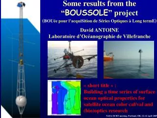
Twelve-year achievements of the BOUSSOLE bio-optics time series project. Emilie Diamond, Vincenzo Vellucci, David Antoine, Bernard Gentili, Grigor Obolensky, Francis Louis, Josephine Ras, Vincent Taillandier, David Luquet

E N D
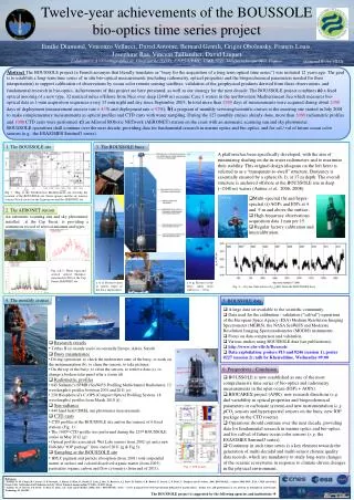
Twelve-year achievements of the BOUSSOLE bio-optics time series project Emilie Diamond, Vincenzo Vellucci, David Antoine, Bernard Gentili, Grigor Obolensky, Francis Louis, Josephine Ras, Vincent Taillandier, David Luquet Laboratoire d’Océanographie de Villefranche (LOV), CNRS-UPMC, UMR 7093, Villefranche-sur-Mer, France diamond@obs-vlfr.fr Abstract The BOUSSOLE project (a French acronym that literally translates as “buoy for the acquisition of a long term optical time series”) was initiated 12 years ago. The goal is to establish a long-term time series of in situ bio-optical measurements (including radiometry, optical properties and the biogeochemical parameters needed for their interpretation) to support calibration of observations by ocean color remote sensing satellites, validation of the geophysical products derived from these observations, and fundamental research in bio-optics. Achievements of this project are here presented, as well as our strategy for the next decade. The BOUSSOLE project combines a) a fixed optical mooring of a new type, 32 nautical miles offshore from Nice over deep (2440 m) oceanic Case 1 waters in the northwestern Mediterranean Sea which measures bio-optical data as 1-min acquisition sequences every 15 min night and day since September 2003. In total more than 2400 days of measurements were acquired during about 2900 days of deployment (measurement success rate = 83% and deployment rate = 92%); b) a program of monthly servicing/scientific cruises to the mooring site started in July 2001 to make complementary measurements as optical profiles and CTD casts with water sampling. During the 127 monthly cruises already done, more than 1000 radiometric profiles and 1000 CTD casts were performed; c) an AErosolROboticNETwork (AERONET) station on the coast with an automatic scanning sun and sky photometer. BOUSSOLE operations shall continue over the next decade, providing data for fundamental research in marine optics and bio-optics, and for cal / val of future ocean color sensors (e.g., the ESA/GMES Sentinel3 series). 1. The BOUSSOLE site 3. The BOUSSOLE buoy A platform has been specifically developed, with the aim of minimizing shading on the in-water radiometers and to maximize their stability. This original design (diagram on the left here) is referred to as a “transparent-to-swell” structure. Buoyancy is essentially ensured by a sphere (b, f), at 17 m depth. The overall structure is anchored offshore at the BOUSSOLE site in deep (~2440 m) waters (Antineet al., 2006, 2008). a) e) Fig. 1: Map of the Northwestern Mediterranean sea showing the location of the BOUSSOLE site (black square) and the six transect stations (black circles) in the Ligurian sea and the AERONET site. h) b) f) • Multi-spectral (h) and hyper-spectral (i) AOPs and IOPs at 4 and 9 m and above the surface; • High frequency observations: acquisition data 1 min per 15; • Regular factory calibration and intercalibration. h) at 4 m i) at 9 m i) 2. The AERONET station An automatic scanning sun and sky photometer, installed at the Cap Ferrat, is providing a continuous record of aerosol amounts and types. c) g) d) Fig. 2 & 3 : Water vapor and aerosol optical thickness measured in 2010 at the Cap Ferrat AERONET site a to d) Pictures taken at various stages of the buoy deployment e to g) Pictures of the buoy taken from surface to ~ -35 m Fig. 4: ~10-year time series of rw(443) from the BOUSSOLE buoy. 4. The monthly cruises a) g) 5. BOUSSOLE data b) c) • A large data set available to the scientific community. • Data used for the calibration / validation (“cal/val”) operations of the European Space Agency (ESA) Medium Resolution Imaging Spectrometer (MERIS), the NASA SeaWiFS and Moderate Resolution Imaging Spectroradiometer (MODIS) instruments. • Focus on data comparison and validation. • Various studies using BOUSSOLE data (see publications). • http://www.obs‐vlfr.fr/Boussole • Data exploitation: posters #13 and #246 (session 1), poster #227 (session 2); talk by Kheireddine, Wednesday 09:00 AC9 CDOM Chl Fluo IOP package • Research vessels • Téthys II (a) mainly used (occasionally Europe, Antéa, Suroît) • Buoy maintenance • Diving operations: to check the underwater state of the buoy, to work on the instrumentation (b), to clean the sensors, to take pictures; • On the top of the buoy: to clean the sensors, to retrieve data (c), to change a broken solar panel after a storm (d). • Radiometric profiles • 845 Satlantic’s SPMR (SeaWiFS Profiling Multichannel Radiometer, 13 wavelengths) profiles between 2001 and 2011 (e); • 250 Biospherical’s C-OPS (Compact Optical Profiling System, 18 wavelengths) profiles from March 2010 (f). • Sun radiance • 440 hand held CIMEL sun photometer measurements. • CTD casts • CTD profiles at the BOUSSOLE site and on the transect of 6 fixed stations (Fig. 1); • The 1000th CTD profile was performed during the 123rd BOUSSOLE cruise in May 2012 (g); • Optical profiles associated: Wet Labs sensors from 2002 (g) and a new Hobilabs “IOP package” from end of 2011 (g & Fig 5). • Sampling at the BOUSSOLE site • HPLC pigment and particle absorption (from 2001) total suspended matter at surface and colored dissolved organic matter (from 2005), particulate organic carbon and flow cytometry (from end of 2011). d) 6. Perspectives - Conclusion • BOUSSOLE is now established as one of the most comprehensive time series of bio-optics and radiometry measurements in the open ocean (IOPs + AOPs). • BIOCAREX project (ANR): new research directions (e.g.diel variability in optical properties and biogeochemical parameters or carbonate system) and new instrumentation (e.g.pCO2 sensors and hyperspectral sensors on the buoy, new IOP package on the CTD rosette). • Operations should continue over the next decade, providing data for fundamental research in marine optics and bio-optics, and for cal/val of future ocean color sensors (e.g. the ESA/GMES Sentinel3 series). • Continuity in such time series is a key element towards the generation of multi-decadal and multi-sensor climate quality data records, which are mandatory to study long-term changes of the oceanic ecosystems in response to climate-driven changes in the physical environment. e) f) Fig. 5: IOP profile. • References • Antoine, D. M. Chami, H. Claustre, F. D'Ortenzio, A. Morel, G. Bécu, B. Gentili, F. Louis, J. Ras, E. Roussier, A.J. Scott, D. Tailliez, S. B. Hooker, P. Guevel, J.-F. Desté, C. Dempsey and D. Adams. 2006, BOUSSOLE : a joint CNRS-INSU, ESA, CNES and NASA Ocean Color Calibration And Validation Activity. NASA Technical memorandum N° 2006 - 214147, 61 pp. • Antoine, D., P. Guevel, J.-F. Desté, G. Bécu, F. Louis, A.J. Scott and P. Bardey, 2008a. The « BOUSSOLE » buoy – A new transparent-to-swell taut mooring dedicated to marine optics : design, tests and performance at sea, Journal of Atmospheric and Oceanic Technology, 25, 968-989. • The BOUSSOLE project is supported by the following agencies and institutions