River Systems
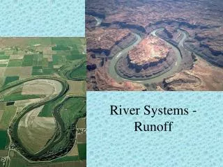
River Systems. watershed . land from which water runs off into streams (drainage basin). Surf your watershed http://www.epa.gov/surf/. Know your watershed http://ctic.purdue.edu/kyw/kyw.html. tributaries. feeder streams that flow into a main river. divide.

River Systems
E N D
Presentation Transcript
watershed • land from which water runs off into streams (drainage basin)
Surf your watershed http://www.epa.gov/surf/ Know your watershed http://ctic.purdue.edu/kyw/kyw.html
tributaries • feeder streams that flow into a main river
divide • ridges or elevated regions of high ground that separate watersheds headwaters • beginning of a stream
channel • the path that a stream follows
bank bed
headward erosion • process of lengthening and branching of a stream
stream piracy • the capture of a stream in one watershed by a stream with a higher rate of erosion in another watershed
Stage 1 - Beaverdam Creek, Gap Run, and Goose Creek flow eastward through the Blue Ridge and enter the Potomac.
Stage 2 - As the land is eroded downward, the three east flowing creeks do not have the power to erode as far through the Blue Ridge as the Shenandoah, Potomac system. The Shenandoah extends itself southward by headward erosion through the relatively high land west of the Blue Ridge. It eventually captures Beaverdam Creek.
Stage 3 - The capture of Beaverdam Creek added more discharge to the Shenandoah which was able to therefore erode more. Headward erosion leads to the capture of Gap Run. The water gaps where Beaverdam Creek and Gap Run used to flow through the Blue Ridge are left as wind gaps.
Stage 4 - Eventually Goose Creek is captured as well. Snicker's Gap, Ashby Gap, and Manassas Gap are left as wind gaps. As the land on either side of the ridge is eroded down together with the ridge summit, the relative elevation of the wind gaps becomes higher and higher.
channel erosion5 things that affect the rate stream load: material carried by a stream
dissolved load: mineral matter transported in liquid solution
discharge • volume of water moved by a stream within a given time gradient • steepness of a stream slope
water gap • notch formed where the stream has eroded its channel
Youthful river • straight • erodes rapidly • V-shaped • few tributaries • has waterfalls and rapids
Mature river • meandering (winding) • slow erosion • U-shaped • lots of tributaries • holds lots of water
Old river • gradient and velocity decreases • no more erosion • more meandering
rejuvenated river • a river whose gradient increases due to movement in the Earth’s crust (form a step-like terrace) or velocity increases due to more water movement
Stream Deposition as the velocity of a stream decreases, it drops the sediment it was carrying
delta • underwater deposit of sediment at the mouth of a river or stream
alluvial fan • fan-shaped deposit at the base of a slope on land
floodplain • part of the valley floor that may be covered with water during a flood