River Systems
River Systems. Earth Space Science Mr. Coyle. The Hydrologic Cycle. Infiltration = Groundwater System. Runoff = Surface Water System Runoff = Precipitation - Evapotranspiration. Where is the Water ?. RIVERS & STREAMS. Water Reservoirs The Hydrologic Cycle Surface Water Systems

River Systems
E N D
Presentation Transcript
River Systems Earth Space Science Mr. Coyle
The Hydrologic Cycle • Infiltration = Groundwater System • Runoff = Surface Water System • Runoff = Precipitation - Evapotranspiration
RIVERS & STREAMS • Water Reservoirs • The Hydrologic Cycle • Surface Water Systems • Meandering • Deltas/Alluvial Fans • Floods and flooding
www.aquatic.uoguelph.ca/rivers/chintro.htm Importance of rivers • Rivers: • Provide water and nutrients for agriculture • Provide habitat to diverse flora and fauna • Provide routes for commerce • Provide recreation • Provide electricity
Natural Watercourses • Discharge- volume of water • Velocity- rate of water movement • Gradient- slope of inclined surface
Variation in time and space • The shape, size and content of a river are constantly changing, forming a close and mutual interdependence between the river and the land it traverses.
www.dec.state.ny.us/website/2000/watersheds.gif www.epa.gov/watertrain/ecology/ecology21.html www.aquatic.uoguelph.ca/rivers/chwater.htm What is a Watershed?
U.S. Precipitation Map Notice the effect of the Rocky Mountains U.S. Runoff Map
Near-Laminar flow in the center of a river channel Turbulent flow in the headwaters of a rushing mountain stream
So Where Does The Stream Move Fastest? • Headwaters move slowest • Mouth of stream moves fastest • Laminar flow is more efficient than turbulent flow. • Deeper stream move faster than shallow streams
Longitudinal Stream Profile Can be divided into 3 main parts Drainage (Tributary) System Transport System Distributary System
Drainage System • Stream energy is spent eroding downward into the basement rock and... • Moving sediment • Creates “V” shaped canyon and valleys • When streams emerge from the mountain front, they often deposit some of this sediment forming alluvial fans.
Aging Rivers: How Old Is It? • Young- rapid bed erosion, waterfalls, rapids, v-shaped valleys, few tributaries, low volume • Mature- well established tributaries, larger volume of water, erode banks and not the bed (bottom), meanders, oxbow lakes
Braided Pattern = high slope + high stream power + coarse bed materials
Braided Streams & Rivers • High sediment load • Constantly changing course • Floodplain is completely occupied by channels • Many small islands called mid-channel bars • Usually coarse sand and gravel deposits.
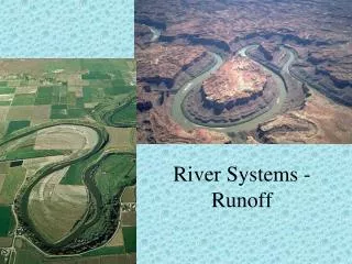
Meandering Rivers • Constantly erode material - Cut bank • Constantly deposit material - Point bar • Change their channel course gradually • Create floodplains wider than the channel • Very Fertile soil • Subjected to seasonal flooding
Point Bar Deposits Point bar deposits grows laterally through time
Cut bank erosion Point bar deposits } Meander loop
Meandering stream flowing from top of screen to bottom
Maximum deposition Maximum erosion
Meander scars Oxbow Lake Oxbow cuttoff