River Systems
River Systems. Chapter 15. 15.1 – The Water Cycle. Water Cycle. Evapotranspiration Total loss of water by an area Evaporation + transpiration by organisms Evapotranspiration increases With temperature With vegetation With wind. Water Budget. Precipitation = Evapotranspiration + Runoff

River Systems
E N D
Presentation Transcript
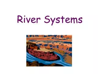
River Systems Chapter 15
Water Cycle • Evapotranspiration • Total loss of water by an area • Evaporation + transpiration by organisms • Evapotranspiration increases • With temperature • With vegetation • With wind
Water Budget • Precipitation = Evapotranspiration + Runoff • Globally balanced • Locally not balanced • Factors affecting local water budget • Temperature Vegetation • Wind Rainfall amounts
Global Water Oceans (97%) – too salty too use Ice caps (2%) Ground Water (<1%) Rivers, lakes, reservoirs…(<0.01%)
Water Use in U.S. ~ 100 – 150 gallons/day/person (municipal) ~ 2000 gallons/day/person total use Agriculture, hydroelectric, industry
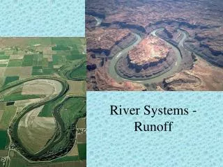
How rivers develop • A river system begins to form when precipitation exceeds evapotranspiration in a given area. • After soil soaks what it can hold, excess water moves downslope as runoff. • Runoff erodes rock & soil & may form a ditch called a gully • Eventually develops into a permanent stream
River System Parts • Tributaries • Feeder streams into main stream
River System Parts White Lumpkin Dawson Habersham Lake Lanier Watershed Area Hall Forsyth • Watershed • Area that drains into a particular stream
River System Parts • Divide • Separates watersheds
Channel Erosion • Headward Erosion • Channel erodes at river head in opposite direction of flow
Stream Piracy Pirate stream One stream takes over and begins to drain an area Pirate stream erodes faster
Stream Load • Suspended load • Fine sand and silt • Bed load • Larger materials bouncing down stream • Dissolved load • Transported in liquid form
Stream Load • Suspended load: particles of fine sand and silt • Bed load: larger, coarser materials (sand, gravel, pebbles) • Dissolved load: mineral matter suspended in liquid solution
More River System Parts • Stream Discharge • Volume of water that a stream transports • Higher velocity = higher discharge
More River System Parts • Stream gradient • Steepness • Generally steeper near headwaters • Steeper means higher velocity
Gradients Steep Gradient Near headwater Gentle Gradient Far from headwater Mississippi River, New Orleans Yellowstone River, WY
Meandering Channels Slow moving streams tend to wander They form meanders Winding patterns of wide curves Slowness causes bank erosion as opposed to bed erosion
Meanders and Lakes Oxbow Lakes: A meander curves and forms a narrow neck. When this narrow neck is cut off, the meander is isolated from the river and forms an oxbow lake. Oxbow lakes
Braided Streams Stream with multiple channels that divide and rejoin around sediment bars Result of large sediment load
Deltas Fan-shaped mass of deposited material at the mouth of a stream or river
Alluvial Fan Deltas formed on land Caused by temporary streams (run off)
Floodplains The part of a valley floor that may be covered with water during a flood.
Natural Levees When a stream overflows its banks and spreads out over the floodplain, the stream slows down and deposits coarse sediment on the river banks. This sediment builds up and raises the height of the river banks. This is a natural levee. Finer sediments are washed out into the floodplain.
Flood Control Human activities contribute to flooding: logging & clearing land of vegetation lead to increased erosion. Natural events like fires can increase likelihood of flooding.
Flood Control Direct: Building artificial structures that redirect flow of water Examples: dams, levees
Flood control Indirect methods: structures are not specifically built and natural methods are used like soil & forest conservation These prevent excess runoff during periods of heavy rainfall
Living in Floodplains Sediments deposited during floods are rich in minerals and nutrients. Rich soils draw people to live there for farming. Convenient access to river for shipping, fishing, and transportation also make people want to live here.
Life Cycle of Lakes • Precipitation forms in a depression and forms a lake. • A lake loses water as it drains or evaporates. • A common cause of excess drainage? An outflowing stream erodes its bed below the level of the lake basin. • As water is lost, the lake basin may eventually become dry land. • Lakes can also fill up with sediment and disappear. • Sediments are carried by streams or in runoff from land.