Download
1 / 17
200 likes | 458 Vues
Measuring Global Sea Level Rise With Satellite Radar Altimetry. ASIC**3 Workshop -- May 2006. Laury Miller NOAA/NESDIS Lab for Satellite Altimetry. ASIC**3 Workshop -- May 2006. Special Thanks To:. Professor Gary Mitchum, Univ. of South Florida Remko Scharroo, Altimetrics, LLP

E N D
Measuring Global Sea Level Rise With Satellite Radar Altimetry ASIC**3 Workshop -- May 2006 Laury Miller NOAA/NESDIS Lab for Satellite Altimetry ASIC**3 Workshop -- May 2006 ASIC**3 Workshop -- May 2006
Special Thanks To: Professor Gary Mitchum, Univ. of South Florida Remko Scharroo, Altimetrics, LLP John Lillibridge, NOAA Lab for Satellite Altimetry ASIC**3 Workshop -- May 2006
Talk Outline The Sea Level Rise Measurement Problem Measuring a small trend or acceleration in the presence of large regional and decadal variability Dealing with relatively short, possibly gappy records. How the altimeter works Relative calibration: island tide gauge network (poor geodetic control) Absolute calibration: geodetically controlled sites at Harvest Platform, Lampadusa, etc. In the Future? ASIC**3 Workshop -- May 2006
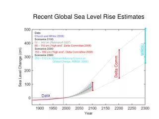
Decadal Rate (1992 to 2005) 2.97+/-0.4 mm/yr 20th Century Rate From Tide Gauges 1.8+/-0.3 mm/yr Altimeter observations show sea level rising nearly 50% faster over the past decade than over the 20th century, as determined from tide gauges. It is unclear whether this reflects a long-term change or evidence of decadal variability. Global Mean Sea Level From Multiple Altimeters ASIC**3 Workshop -- May 2006
mm/year Global Sea Level Trends: 1993 to Feb 2006From TOPEX & Jason-1 Altimetry • Large regional variability. • Largest average rise in southern hemisphere. ASIC**3 Workshop -- May 2006
Altimeter range From radar round-trip time • Satellite altitude From from various tracking systems • Sea surface height Difference:satellite altitude – altimeter range – corrections Sum of:geoid + dynamic topography + tides The Principle of Satellite Altimetry ASIC**3 Workshop -- May 2006
Current Tide Gauge & Geodetic Sites ASIC**3 Workshop -- May 2006
Relative Sea Level Trends & Distance From Hudson Bay Miller & Douglas, Phil Trans. Roy. Soc., 2006 ASIC**3 Workshop -- May 2006
TOPEX vs. Christmas Island Sea Level ASIC**3 Workshop -- May 2006
TOPEX Drift (Altimeter - TideGauge Sea Level at ~50 Sites) Altimeter Algorithm Error The failure to detect this error early in the mission lead to the publication of an erroneous high rate of sea level rise in SCIENCE magazine. ASIC**3 Workshop -- May 2006
TOPEX Drift (+/-0.4 mm/yr)After Correction ASIC**3 Workshop -- May 2006
Jason-1 Altimeter (2001 ->) vs. Tide Gauges Nominal Drift ASIC**3 Workshop -- May 2006
Jason-1 Altimeter (2001 ->) vs. Tide Gauges After Correcting Water Vapor Radiometer Drift ASIC**3 Workshop -- May 2006
TOPEX, Poseidon & Jason-1 Bias EstimatesThe Absolute Calibration Problem 14 CM ?? ASIC**3 Workshop -- May 2006
NASA/NOAA Absolute Altimetry Calibration SiteHarvest Platform, Santa Barbara CA • Monitors absolute (geocentric) bias and bias drift through a collection of supporting measurements • Platform Located directly beneath a Jason-1 track line. • Sea height wrt platform determined with redundant tide gauge systems • Platform height wrt reference ellipsoid determined with GPS and Very Long Baseline Interferometry (VLBI). • Water vapor radiometer used to determine radar path length correction. For TOPEX altimeter: bias 7.3 +/- 4.3 mm, bias drift -0.4 +/- 1.5 mm/yr Bias drift error is comparable to rate of global sea level rise! ASIC**3 Workshop -- May 2006
High Accuracy Altimetry: Past, Present, and Future Shift in Agency Responsibility Going From Research To Operations • 1991-2005: TOPEX Joint NASA/CNES mission • 2001-->: Jason-1 Joint NASA/CNES mission • Jason-2 (2008): NASA/CNES with NOAA & EUMETSAT as junior partners. • Jason-3 (2013?): NOAA/EUMETSAT with NASA & CNES as junior partners. ASIC**3 Workshop -- May 2006
The Calibration Challenge • Need Overlap Between Missions -- Can’t Depend on Absolute Calibration • Need To Maintain International Tide Gauge Network • NOAA Currently Supporting more than 40 gauges • Need to upgrade many sites with GPS. • Need To Lower Current Error In Bias Trend Estimate To Improve Ability To Detect An Acceleration. ASIC**3 Workshop -- May 2006