Download

1 / 92
930 likes | 1.39k Vues
Ch 16 – Aviation Weather Resources. Ch 16 – Aviation Weather Resources. Section A – The Weather Forecasting Process Collecting Weather Data Processing Weather Data Making the Forecast Forecasting Methods Forecasting Accuracy. Ch 16 – Aviation Weather Resources.

E N D
Ch 16 – Aviation Weather Resources • Section A – The Weather Forecasting Process • Collecting Weather Data • Processing Weather Data • Making the Forecast • Forecasting Methods • Forecasting Accuracy
Ch 16 – Aviation Weather Resources • Section B – Aviation Weather Forecast Products • Forecast Products in Text Format • Terminal Aerodrome Forecast (TAF) • Area Forecast (FA) • In-flight Weather Advisories (WS, WST, WA) • Transcribed Weather Broadcasts (TWEB) • Winds and Temperatures Aloft Forecast (FD) • Other Advisories, Watches, and Warnings
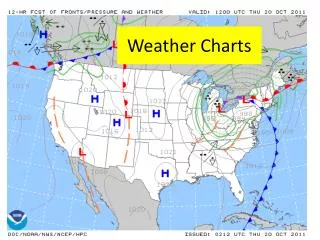
Ch 16 – Aviation Weather Resources • Forecast Products in Graphic Format • Significant Weather Prognostic Chart • Forecast Winds and Temperatures Aloft Chart
Ch 16 – Aviation Weather Resources • Section C – Aviation Weather Information Sources • FAA Flight Service Stations (FSS) • Continuous Broadcasts of Weather Information (TWEB, HIWAS) • Other Weather Information Sources • Weather on the Internet
Ch 16 – Aviation Weather Resources • Weather information and forecasts are beneficial in numerous ways • Prediction of warm temperatures or the change of rain helps us decide whether to plan a picnic or carry an umbrella for the day • Forecasts of severe weather such as blizzards, thunderstorms, or hurricanes help communities prevent property damage and save lives
Ch 16 – Aviation Weather Resources • As a pilot, weather influences your life in a unique way • Determinations regarding weather conditions must be made before every flight, and crucial weather decisions may have to be made in-flight
Ch 16 – Aviation Weather Resources • A wide variety of weather resources are available to assist you in this decision-making process • We describe the on-going process of collecting, transmitting, and processing weather data to produce a weather forecast • We then consider various formats of aviation weather forecasts, and the sources of aviation weather information
Ch 16 – Aviation Weather Resources • When you complete Chapter 16, you should understand how weather information is compiled and processed, and some basic concepts of forecasting • You should also be familiar with the variety of aviation weather forecasts available to you, as well as the sources of aviation weather information to help you make safe preflight and in-flight decisions
Ch 16 – Aviation Weather Resources • Section A: The Weather Forecasting Process • There are three important steps in the forecasting process: data collection, data processing and forecasting • Collecting Weather Data • The World Meteorological Organization (WMO), a United Nations agency is responsible for the standardization of observations and the international exchange of weather data
Ch 16 – Aviation Weather Resources • Processing Weather Data • The National Weather Service (NWS), a part of the National Oceanic and Atmospheric Administration (NOAA), is the U.S. government agency that is primarily responsible for gathering and processing meteorological data and for providing weather forecasts and warnings
Ch 16 – Aviation Weather Resources • These continuing and complicated tasks are conducted by several NWS offices including the National Centers for Environmental Protection (NCEP) and local Weather Forecast Offices (WFO) • One of the components of the NCEP is the Aviation Weather Center (AWC) which specializes in the preparation of aviation weather information
Ch 16 – Aviation Weather Resources • Forecasting Methods • The most comprehensive forecast technique today is numerical weather prediction (NWP) which solves a set of mathematical equations (a numerical model) to predict the weather
Ch 16 – Aviation Weather Resources • Forecasting Accuracy • In comparison to persistence forecasts, the accuracy of meteorological forecasts, which are based on scientific knowledge as used by NWP and weather forecasters, is much better and decreases much more slowly as the forecast period increases
Ch 16 – Aviation Weather Resources • However, for the longest forecast periods, the accuracy of meteorological forecasts is no better than that of climatological forecasts, which are based purely on past averages and are typically not very accurate at all
Ch 16 – Aviation Weather Resources • Forecasting the weather is somewhat chaotic, which is not too far from the mark. As applied to weather forecasting, chaos theory describes the potential difficulty in making forecasts for long periods of time • The science of chaos began in the early 1960s with a mathematician and atmospheric scientist named Edward Lorenz and his exploration of computer forecasts
Ch 16 – Aviation Weather Resources • Section B: Aviation Weather Forecast Products • Decoding keys for aviation weather forecast products are included in Appendix D • In addition, FAA Advisory Circular 00-45 Aviation Weather Services contains further information
Ch 16 – Aviation Weather Resources • Selectivity – requires that you know exactly what you need, what is available and where and when it is available • Visualization – forming a mental image of current and forecast weather conditions
Ch 16 – Aviation Weather Resources • Forecast Products in Text Format • Forecast products in text format include: • Terminal Aerodrome Forecasts (TAF) – describes weather conditions that are expected to occur within a 5 nm radius of an airport over a 24 hour period.
Ch 16 – Aviation Weather Resources • In the US routine TAFs are issued 4 times daily at 0000Z, 0600Z, 1200Z, and 1800Z. • The TAF is one of the most valuable sources for the predicted weather at a specific airport. • Predicted sky condition, visibility, weather and obstructions to vision, wind direction and speed, and expected changes during the forecast period can be derived from TAFs.
Ch 16 – Aviation Weather Resources • Area Forecasts (FA) – expected VMC, clouds and general weather conditions over an area the size of several states are described in an Area Forecast (FA). • An FA is used to determine en-route weather, including conditions at airports that do not have terminal forecasts.
Ch 16 – Aviation Weather Resources • An FA should always be used in conjunction with the most recent in-flight weather advisories. • Area forecasts are normally issued three times daily and are valid for 18 hours.
Ch 16 – Aviation Weather Resources • An FA has four sections: • Header – describes the source of the FA, the date and time of issue, the valid times and the areas the FA covers • Precautionary Statements – describe IFR and mountain obscurations, thunderstorm hazards, and states that all heights are MSL unless otherwise noted
Ch 16 – Aviation Weather Resources • Synopsis – a brief summary identifying the location and movement of pressure systems, fronts, and circulation patterns for the 18 hour forecast period. • VFR Clouds and Weather – this section lists expected sky condition, visibility and weather for the next 12 hours and an outlook for the following 6 hours
Ch 16 – Aviation Weather Resources • Area forecasts are issued by the Aviation Weather Center (AWC) for the six regions in the contiguous US. • The Alaskan Aviation Weather Unit issues an FA for the state of Alaska while the Honolulu WFO handles Hawaii. • Special FAs are also issued for the Gulf of Mexico and international airspace
Ch 16 – Aviation Weather Resources • Within its prescribed area, an FA describes weather features and conditions relative to common geographical regions and features
Ch 16 – Aviation Weather Resources • The contiguous US is divided into 6 forecast areas • SFO – San Francisco • SLC – Salt Lake City • DFW – Dallas / Fort Worth • CHI – Chicago • BOS – Boston • MIA – Miami
Ch 16 – Aviation Weather Resources • ***The area forecast covers an area of several states and can be used to determine en-route weather and conditions at your destination if no TAF has been issued
Ch 16 – Aviation Weather Resources • The geographical area designator map can be useful in determining the specific area described by an area forecast • The contiguous US is divided into six forecast areas (colored area) • You may want to keep a copy of this map with your flight planning materials so that you have access to it when you obtain weather information.
Ch 16 – Aviation Weather Resources • The accuracy of weather forecasts as a function of the forecast period and the forecasting method • Comparison of the accuracy of persistence, meteorological, and climatological forecasts for forecast periods from a few hours to several days • Very general
Ch 16 – Aviation Weather Resources • The actual rate of deterioration of the accuracy of forecasts for a given airport depends on its location, the season, and the forecast variable.
Ch 16 – Aviation Weather Resources • In-flight Weather Advisories (WS, WST, WA) • consist of either an observation and a forecast, or just a forecast for the development of potentially hazardous weather
Ch 16 – Aviation Weather Resources • SIGMET (WS) – describes conditions which can pose hazards to all aircraft. • SIGMETs are valid for up to four hours.
Ch 16 – Aviation Weather Resources • If the following phenomena are observed or expected to occur, a SIGMET is issued • 1. Severe icing not associated with thunderstorms • 2. Severe or extreme turbulence or clear air turbulence not associated with thunderstorms • 3. Dust storms or sandstorms lowering surface or in-flight visibilities to below three miles • 4. Volcanic ash
Ch 16 – Aviation Weather Resources • ***SIGMETs are issued as warnings of hazardous weather, such as severe icing, which is of operational interest to all aircraft
Ch 16 – Aviation Weather Resources • Convective SIGMETs (WST) – describes convective activity that is potentially hazardous to all categories of aircraft
Ch 16 – Aviation Weather Resources • Convective SIGMETs (WST) – describes convective activity that is potentially hazardous to all categories of aircraft • Bulletins are issued hourly with special advisories issued as required • The forecast period for a WST is two hours or less • Criteria for issuance are any of the following conditions
Ch 16 – Aviation Weather Resources • Severe thunderstorms (surface winds greater than or equal to 50 knots and/or hail at the surface greater than or equal to ¾ inches in diameter and/or tornadoes) • Embedded thunderstorms • A line of thunderstorms
Ch 16 – Aviation Weather Resources • Thunderstorms producing precipitation with an intensity greater than or equal to heavy and affecting 40% or more of an area at least 3,000 square miles
Ch 16 – Aviation Weather Resources • Convective SIGMET bulletins are issued for the Eastern (E), Central (C), and Western (W) United States • Convective SIGMET text is presented in figure 16-7