GIS Analysis Functions
GIS Analysis Functions. Objectives. To be able to explain what the following GIS analysis functions are: Transformations Conflation Edge Matching Editing Functions Query Functions Overlay Operations Neighborhood Operations Connectivity Functions. Transformations.

GIS Analysis Functions
E N D
Presentation Transcript
Objectives • To be able to explain what the following GIS analysis functions are: • Transformations • Conflation • Edge Matching • Editing Functions • Query Functions • Overlay Operations • Neighborhood Operations • Connectivity Functions
Transformations • Format Transformations - sometimes topology must be built • Geometric Transformations - registration to a common coordinate system (rubber sheeting or warping) • Between Geometric Projects - i.e. Latitude/Longitude to PLSS
Conflation • procedure of reconciling the positions of corresponding features in different layers (i.e. if two forests layers are off - conflation fixes)
Edge Matching • adjusts the position features that extend across map boundaries ("postage-stamping" maps together and resolving the differences in features along their edges...)
Editing Functions • slivers or splinters • line snapping • over- or undershoots
Query Functions • retrieve records in the attribute database according to the conditions specified by the operator
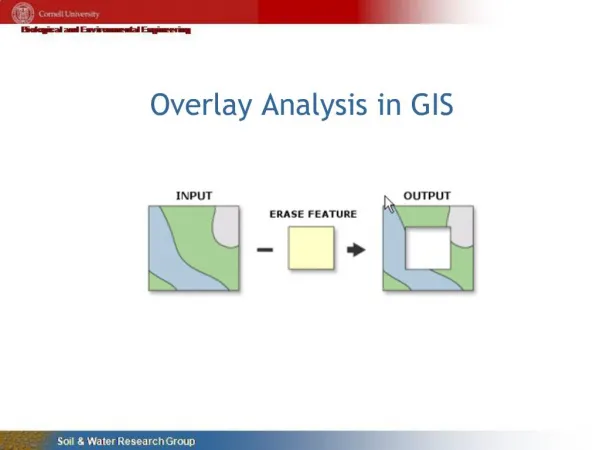
Overlay Operations • arithmetic & logical overlay operations • arithmetic - addition, subtraction, division, multiplication • logical - where a specified set of conditions occur (or doesn't occur) together
Neighborhood Operations • evaluate the characteristics of the area surrounding a specified location
Connectivity Functions • use functions that accumulate values over the area being traversed
Conclusion • GIS analysis functions use the spatial and non-spatial attribute data to answer questions about real-world • Spatial analysis functions that distinguishes GIS from other information systems