HOW TO DRAW TEXAS
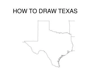
HOW TO DRAW TEXAS. x. It’s easy to draw the state of Texas if you think in terms of proportions . First, draw the northern boundary of the Panhandle. This is your base measurement. X. X. Next, draw the eastern edge of the Panhandle. It is about the same length as the northern edge.

HOW TO DRAW TEXAS
E N D
Presentation Transcript
x • It’s easy to draw the state of Texas if you think in terms of proportions. • First, draw the northern boundary of the Panhandle. This is your base measurement.
X X • Next, draw the eastern edge of the Panhandle. • It is about the same length as the northern edge.
The 3rd line you’ll draw is the western edge of the Panhandle. It is about twice as long as its northern border. X X 2X
Your 4th line will be the straight line west from the southern end of the Panhandle. It is about 1 ½ times as long as the northern edge of the Panhandle. X X 2X 1 ½ X
Now, draw the northern border of Texas—the Red River. Draw a “river” line east from the eastern line of the Panhandle that is about the same length as the western edge of the Panhandle. X X 2X 2X 1 ½ X
Draw the eastern border Draw a straight line south from the eastern end of your Red River line until it is about even with the southern end of the western edge of the Panhandle. X X 2X 2X 1 ½ X
To finish the eastern boundary, draw a “river” line (this is the Sabine River) in a slight arc to the east. This should be about as long as the northern boundary of the Panhandle. X X 2X 2X 1 ½ X X
Now, draw the coastal boundary of Texas. Draw an arc to the southwest until the bottom of the arc is about half way along the Red River. X X 2X 2X 1 ½ X X
X X 2X 2X 1 ½ X X • Next, draw the southern border—the Rio Grande. • From the western-most tip of Texas, draw a “river” line south at about a 45o angle. • When your river line reaches the western edge of the Panhandle, it should be slightly south of the southeastern corner of Texas.
Gently arc your line north & east until you are about halfway through the Panhandle. Continue your river line south until you meet the coastal boundary. X X 2X 2X 1 ½ X X
Voila! Now you have drawn your very own map of Texas! GREAT!!!!!