Download
1 / 12
120 likes | 263 Vues
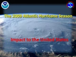
2009 Updated Atlantic Hurricane Season Outlook. Dr. Gerry Bell Lead Seasonal Forecaster: Climate Prediction Center NOAA/ NWS/ NCEP. Collaboration With National Hurricane Center/ NOAA/ NWS Hurricane Research Division/ NOAA/ OAR. Outline. Outlook release logistics Outlook update highlights

E N D
2009 Updated Atlantic Hurricane Season Outlook Dr. Gerry Bell Lead Seasonal Forecaster: Climate Prediction Center NOAA/ NWS/ NCEP Collaboration With National Hurricane Center/ NOAA/ NWS Hurricane Research Division/ NOAA/ OAR
Outline • Outlook release logistics • Outlook update highlights • NOAA’s 2009 Atlantic hurricane season outlooks • Historical Atlantic seasonal activity • El Niño develops during June • Recent SST anomalies • Current and expected ENSO status • Science behind the outlook: Competing climate factors • Security and Release procedures • Summary 2
Outlook Release Logistics • Release time is 10:00 am EDT, 6 August 2009 • Issued via press release and press teleconference (G. Bell) • Official forecast discussion with slides on CPC, NHC web pages. • TV, radio, and print media interviews (G. Bell) Pre-release Logistics • Briefings by G. Bell: NCEP (31 July), NWS (3 August), • R. Spinrad (briefing by S. Goldenberg), Bill Reid (briefing by R. Pasch) • Event memo to Dr. Lubchenco 3
Outlook Update Highlights • The updated outlook calls for a 90% chance of a normal or below-normal Atlantic hurricane season. • In May, we indicated an approximately 50% chance of El Niño developing during the hurricane season. El Niño has now developed, and we are issuing El Niño advisories. • Early El Niño impacts are expected to substantially offset the ongoing multi-decadal signal and warmer Atlantic SSTs. • Therefore, the probability of a below-normal season (40%) has increased compared to the May outlook, and the predicted range of activity has been reduced. • Hurricane strikes in the U.S. during El Niño include Betsy (1965), Bob (1991), Danny (1997), and Isadore (2002). • A main theme is “Don’t let your guard down.” 4
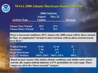
NOAA 2009 Atlantic Hurricane Season Outlooks Season and August May Activity Type Update Outlook Normals Chance Above Normal 10% 25% Chance Near Normal 50% 50% Chance Below Normal 40% 25% Named Storms (NS) 7-11 9-14 11 Hurricanes (H) 3-6 4-7 6 Major Hurricanes (MH) 1-2 1-3 2 ACE (% Median) 60%-110%65%-130% 100% We estimate a 70% probability for the ranges of NS, H, MH, and ACE. • The updated outlook reflects competing climate factors: the multi-decadal signal and El Niño. There is now a 90% chance of a normal to below-normal season. • In May, we indicated an approximately 50% chance of El Niño developing during the hurricane season. El Niño has now developed, and we are issuing El Niño advisories. • The main change from the May outlook is an increased probability of a below-normal season, and a reduction in the expected numbers of NS, H, MH, and ACE. El Niño’s presence now makes an above-normal season unlikely. 5
Historical Atlantic Seasonal Activity NOAA’s ACE index shows the overall strength of the hurricane season. NOAA’s updated 2009 Atlantic hurricane outlook indicates a 70% chance the ACE range will be 60%-110% of the median. This range is lower than was indicated in the May outlook due to the development substantial El Niño impacts. 6
El Niño Develops During June El Niño La Niña Weekly SST departures in Niño 3.4 Region The Niño 3.4 region is indicated by the black box in east-central equatorial Pacific Ocean between 170oW and 120oW, and 5oN and 5oS El Niño developed in June 2009, and CPC began issuing El Niño advisories in early July. NOAA’s Climate Prediction Center (CPC) considers El Niño conditions to be present when the monthly area-averaged SST departure in the Niño 3.4 region reaches +0.5°C, along with consistent atmospheric features. These conditions must also be expected to persist for three consecutive months. 7
Recent Sea Surface Temperature Anomalies El Niño and Warmer Tropical Atlantic • SSTs associated with El Niño are currently more than 1oC above average. The tropical Atlantic and Caribbean Sea are also warmer than average. 8
Current and Expected ENSO Status ENSO Alert System Status: El Nino Advisory* • El Niño conditions are present across the equatorial Pacific Ocean. • Positive sea surface temperature (SST) departures continue to increase across much of the equatorial Pacific Ocean. • Current observations and dynamical model forecasts indicate that El Niño conditions will continue to develop, and are expected to last through the Northern Hemisphere winter 2009-2010. * El Niño Advisory: Issued when El Niño conditions are observed and expected to continue. 9
Science Behind the Outlook: Competing Climate Factors Increased Wind Shear, Fewer Hurricanes Warmer More Shear Warmer Wet Warm, Wet Drier Ongoing Multi-Decadal Signal El Niño El Niño increases the vertical wind shear over the Atlantic, suppressing hurricane activity. During a high-activity era El Niño competes with the multi-decadal signal, most often resulting in a near-normal season. This year, the early development of substantial El Niño impacts increases the chance for a below-normal season. This climate pattern produces key ingredients of an active hurricane era: warmer waters, reduced vertical wind shear, and favorable winds that strengthen cloud systems coming from Africa. 10
Security and Release Procedures • Purpose: • Ensure a fair and equitable release of the economically sensitive information • Ensure simultaneous release to all of the public • Minimize the risk of pre-release access • Briefings: • Only those with a clear “need-to-know” are allowed access to the outlook information • Briefings are granted on the “need-to-know” basis, and cleared through NCEP Office of Director • NHC and OAR leadership are briefed by their respective forecasters • Embargo: • All forecast-related information is embargoed until the outlook is released publicly • No embargoed or advanced copies of the information or pre-release of the information is permitted • Releasing the Outlook • The Outlooks are made available simultaneously on the CPC and NOAA websites • NWS employees are informed through an all-hands e-mail message • All interviews comply with DOC Dept. Admin. Order 219-1, Public Communications • NOAA/ NWS staff should forward media requests to lead forecaster and/or NCEP Public Affairs 11
Summary • The updated outlook calls for a 90% chance of a normal or below-normal Atlantic hurricane season. • In May, we indicated an approximately 50% chance of El Niño developing during the hurricane season. El Niño has now developed, and we are issuing El Niño advisories. • Early El Niño impacts are expected to substantially offset the ongoing multi-decadal signal and warmer Atlantic SSTs. • Therefore, the probability of a below-normal season (40%) has increased compared to the May outlook, and the predicted range of activity has been reduced. • Hurricane strikes in the U.S. during El Niño include Betsy (1965), Bob (1991), Danny (1997), and Isadore (2002). • A main theme is “Don’t let your guard down.” 12