Essential Weather Forecasting and Hazard Awareness in the Western Great Lakes
This guide provides crucial insights into weather forecasting and hazardous weather conditions in the Western Great Lakes region. It covers essential topics such as Red Flag Warnings, key weather factors, and common patterns leading to fire danger, including dry winds and humidity levels. The document also discusses various hazardous weather phenomena like lightning, damaging thunderstorm winds, tornadoes, hail, and flash flooding, along with safety preparedness tips for outdoor work. Stay informed and safe with the latest from the National Weather Service!

Essential Weather Forecasting and Hazard Awareness in the Western Great Lakes
E N D
Presentation Transcript
Weather Forecasting and Hazardous Weather in the Field John Wetenkamp National Weather Service La Crosse Wisconsin
Overview • Red Flag Warnings • Weather Factors • Common Weather Patterns for Red Flag Warnings in the western Great Lakes Region • Hazardous Weather in the Field • Lightning • Damaging Thunderstorm Winds • Tornadoes • Hail • Flash Flooding • New NWS Webpage • New NWS Spot Forecast Page (Coming Soon)
Red Flag Warnings • Issued when weather and “fuel” conditions are conducive for explosive fire growth potential • Extreme Fire Danger • NWS works closely with land managers to determine the need for a Red Flag Warning
Weather Factors • Key weather factors: • Relative Humidity (≤25% WI, MN, IA) • Wind • WI: 15 mph RAWS (Sensor at 20 ft) , 17 mph ASOS (Sensor at 33 ft) • MN and IA: 20 mph • Frequent winds gusts also factored into determining the need for the Red Flag Warning • Temperatures considered • Amount of time since last rainfall (Dryness) • Fuels status determined by land managers. • Canadian Forest Fire Danger Rating System (CFFDRS) • National Fire Danger Rating System (NFDRS)
Red Flag Warning Climatology in the Western Great Lakes/Upper Mississippi River Valley • Climatology: • 1) Spring before Green-up (April and early May) • Warm and dry air masses fairly common • Weather systems can produce strong winds • 2) Fall after a killing frost • Again, strong winds possible with weather systems • After a period of prolonged drought (below normal precipitation for 3-8 months)
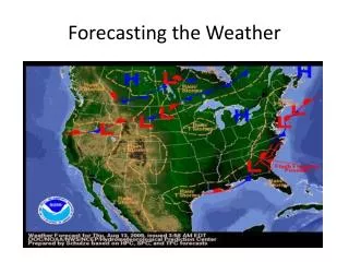
Examples of Weather Patterns That Could Lead To Red Flag Conditions (Spring Fire Season, Pre green-up) (Dry Canadian High Pressure)
Examples of Weather Patterns That Could Lead To Red Flag Conditions (Spring Fire Season, Pre green-up) The high may sit over the region for a few days drying the wildland fuels.
Examples of Weather Patterns That Could Lead To Red Flag Conditions (Spring Fire Season, Pre green-up) Warm & Dry Air
Examples of Weather Patterns That Could Lead To Red Flag Conditions (Spring Fire Season, Pre green-up) Warm & Dry Air
Examples of Weather Patterns That Could Lead To Red Flag Conditions (Spring Fire Season, Pre green-up) As the front draws closer winds increase and combine with the dry conditions to potentially create dangerous wildfire conditions.
Examples of Weather Patterns That Could Lead To Red Flag Conditions (Spring Fire Season, Pre green-up) Strong northwest winds can develop on the back side of the front . These strong winds can also create dangerous wildfire conditions.
Hazardous Weather in the Field • Thunderstorm Hazards • Lightning • Severe ThunderstormWinds • Tornadoes • Hail • Flash Flooding
Lightning • Kills an average of 49 people in the United States each year with hundreds severely injured • If you can hear thunder you are close enough to be struck by lightning • If outdoors • Go to your vehicle • If you don’t have a vehicle nearby • Avoid tall objects such as trees and assume the lightning position
Severe Thunderstorm Winds • Winds ≥ 58 mph • Can cause extensive tree and property damage
Cases of Extreme Winds • July 4th 1977 across northern Wisconsin • Winds estimated at 113 to 157 mph • A damage path of 17 miles wide and 166 miles long Radar Representation of a Bow Echo
Cases of Extreme Winds • July 4th 1999 Boundary Waters Canoe Area • Winds estimated at 80 to 100 mph • Tens of millions of trees blown down • 60 people injured by falling trees, some serious Percentage of trees blown down in northeast Minnesota (USDA Forest Service)
Tornadoes • Tornadoes can occur anytime but are most common in the afternoon and evenings • Can last for a few seconds or hours • Winds speeds of 65 to over 200 mph. • Longest tornado track: 212 miles/ 3.5 hours
Tornadoes • Tornadoes aren’t always visible • Can be obscured by rain, hail, trees, hills What would you see if you were here? Storm Movement
Large Hail • Severe hail • Hail ≥ 1” in diameter (Quarter Size) • Can grow to the size of softballs or larger! • Vivian, SD record hail stone was 8” in diameter • Weight was nearly 2 pounds Record Hail Stone From Vivian, SD July 23, 2010
Flash Flooding • Causes more deaths than any other thunderstorm related hazard! • Don’t drive or walk into flood waters • It only takes 12 inches of flowing water to wash away a small car • 6 inches of fast flowing flood water can knock you off your feet
Severe Weather Preparedness in the Field • Ensure you and your staff are weather aware • Have a means of receiving weather alerts • Have a NOAA Weather Radio with you and make sure it is properly programmed • If you are caught outdoors during a storm • Stay away from trees during lightning and high winds • Your vehicle (with windows up) is a safe place to shelter from lightning • If no shelter is available during a tornado, lie flat in a low spot or ditch and cover your head with your hands • Be alert for flash flooding during and after heavy rainfall. Never cross water of unknown depth and watch out for roads that may have been washed out. • Road/bridge washouts can be narrow and difficult to see, especially when approaching these areas with your vehicle. People have been killed driving into narrow washouts on paved and unpaved roads.
NWS Webpage weather.gov (National View) You can click on your location weather.gov/lacrosse (weather.gov/”enter you local office here”
Accessing Fire Weather Information Takes you to your local NWS Offices Fire Weather Page.
Mobile Phone Friendly Page mobile.weather.gov Zip, City or Place
NWS La Crosse Fire Weather Page(Standardized Local Pages in the near future)
New Spot Page (Coming Soon) http://www.weather.gov/spotnws/
New Spot Page (Coming Soon) Training VideoAvailable (8 min) Lots of great new features with the new SPOT site! YouTube Channelhttps://www.youtube.com/user/NWSDuluth
Thank You Questions? Contact information: john.wetenkamp@noaa.gov