Download
1 / 13
1.15k likes | 4.36k Vues
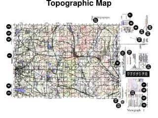
Land Navigation Identify Topographic Symbols on a Military Map. Terminal Learning Objective. Action: Identify Topographic Symbols on a Military Map Conditions: Given a standard 1:50,000 scale topographical map

E N D
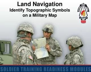
Land Navigation Identify Topographic Symbols on a Military Map
Terminal Learning Objective Action: Identify Topographic Symbols on a Military Map Conditions: Given a standard 1:50,000 scale topographical map Standards: Correctly identify the topographic symbols, colors, and marginal information on a military map
Definition of a Map A map is a graphic representation of the earth’s surface, or part of it, drawn to scale as seen from above, with manmade and natural features appearing as symbols, lines, and colors.
Marginal Information Sheet Name Sheet Number Boundaries, Adjoining Sheets and Elevation Guide Declination Diagram
Marginal Information (con’t) Scale Bar Scales Contour Interval Note Credit Notes
Marginal Information (con’t) GridReferenceBox Legend
Colors on a Map Indicates cultural (man-made) features such as buildings, roads, spot elevations, and all labels. Combined to identify cultural features, all relief features, non-surveyed spot elevations, and elevation such as contour lines on red-light readable maps. Identifies vegetation with military significance such as woods, orchards, and vineyards. Identifies all relief features and elevation such as contours on older edition maps and cultivated land on red-light readable maps. Identifies hydrography or water features such as lakes, swamps, rivers, and drainage. Classifies cultural features, such as populated areas, main roads, and boundaries on older maps. Occasionally, other colors are used to show special information. These colors are indicated in the marginal information. Black Red-Brown Blue Green Brown Red Other
X X CEM Man-made Objects ------- TRAIL PROMINENT FENCE SINGLE TRACK RR DOUBLE TRACK RR
Man-made Objects (con’t) HEAVY DUTY MEDIUM DUTY IMPROVED ROAD UNIMPROVED ROAD
Drainage and Vegetation STREAM INTERMITTENT STREAM LAKE / POND INTERMITTENT LAKE/POND
Drainage and Vegetation (con’t) GRASSLAND MARSH OR SWAMP VINEYARD/ORCHARD WOODS
Contour Lines Contour lines represent vertical distance above or below mean sea level on the ground. Index Intermediate Supplementary
Terminal Learning Objective Action: Identify Topographic Symbols on a Military Map Conditions: Given a standard 1:50,000 scale topographical map Standards: Correctly identify the topographic symbols, colors, and marginal information on a military map