Download

1 / 19
350 likes | 1.75k Vues
IDENTIFY TOPOGRAPHIC SYMBOLS ON A MILITARY MAP. 071-329-1000. PRESENTED BY:. TrainingNCO.com. CONDITIONS: . Given a standard 1:50,000-scale military map. STANDARDS:. Identify topographic symbols, colors, and marginal information on a military map with 100 percent accuracy.

E N D
IDENTIFY TOPOGRAPHIC SYMBOLS ON A MILITARY MAP 071-329-1000 PRESENTED BY: TrainingNCO.com
CONDITIONS: • Given a standard 1:50,000-scale military map.
STANDARDS: • Identify topographic symbols, colors, and marginal information on a military map with 100 percent accuracy.
PERFORMANCE STEPS • Identify the colors on a military map. • Identify the symbols on the map that represent physical features, such as physical surroundings or objects, as shown in Table 2. • Identify the marginal information found in the legend.
Identify the colors on a military map. Table 1. Colors on topographic maps.
Identify the colors on a military map. • NOTE: Ideally, every feature on the part of the earth mapped could be shown on the map in its true shape and size. Unfortunately, that is impossible. The amount of detail shown on a map increases or decreases depending on its scale, for example, a map with a scale of 1:250,000 would show a larger area than one with a scale of 1:50,000, but far less detail. Details are shown by topographic symbols. These symbols are shown using six basic colors as shown in Table 1.
PERFORMANCE STEPS • Identify the colors on a military map. • Identify the symbols on the map that represent physical features, such as physical surroundings or objects, as shown in Table 2. • Identify the marginal information found in the legend.
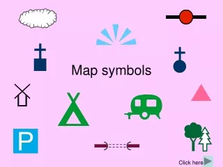
Identify the symbols on the map that represent physical features, such as physical surroundings or objects, as shown in Table 2. Table 2. Features on topographic maps.
Identify the symbols on the map that represent physical features, such as physical surroundings or objects, as shown in Table 2. • Identify each object by its shape on the map. For example, a black, solid square represents a building or a house; a round or irregular blue item is a lake or pond.
Identify the symbols on the map that represent physical features, such as physical surroundings or objects, as shown in Table 2. • Use logic and color to identify each map feature. For example, blue represents water. If you see a symbol that is blue and has clumps of grass, this would be a swamp.
Identify the symbols on the map that represent physical features, such as physical surroundings or objects, as shown in Table 2. • The size of the symbol shows the relative size of the object. Most symbols are enlarged 6 to 10 times so that you can see them under dim light.
Identify the symbols on the map that represent physical features, such as physical surroundings or objects, as shown in Table 2. • Use the legend, which should identify most of the symbols used on the map.
PERFORMANCE STEPS • Identify the colors on a military map. • Identify the symbols on the map that represent physical features, such as physical surroundings or objects, as shown in Table 2. • Identify the marginal information found in the legend.
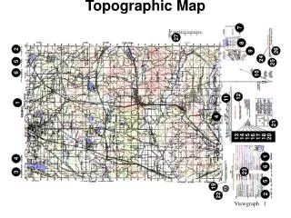
Identify the marginal information found in the legend. • Top of map sheet: • Top left corner--the geographic location covered by the map and the scale of the map. • Top center-the name of the map sheet. • Top right corner--the map edition, the map series, and the map sheet number.
Identify the marginal information found in the legend. • Bottom of map sheet: • Lower left corner--the legend, the name of the agency that prepared the map, the map sheet number, and the map sheet name. • Bottom center--the bar scales in meters, yards, miles, and nautical miles; the contour interval of the contour lines; the grid reference box; the declination diagram; and the G-M angle (mils or degrees). • Lower right corner--the elevation guide, the adjoining map sheet diagram, and the boundaries box, which shows any boundaries that might be on the map.
EVALUATION PREPARATION: • SETUP: On a 1:50,000-scale military map, circle each item of marginal information found on the map. Randomly letter the circled items A through J. Circle an item or feature shown on the map by color. Randomly number each colored item 1 through 10. The items are listed in the TIO. For each Soldier tested, provide a sheet of paper, two pencils, and a duplicate map.
BRIEF SOLDIER: • Tell the Soldier to letter the paper A through J, and then 1 through 10. Tell the Soldier to write the name of the item contained in each lettered and numbered circle on the map.
REFERENCES: • REQUIRED: FM 21-31 FM 3-25.26
IDENTIFY TOPOGRAPHIC SYMBOLS ON A MILITARY MAP 071-329-1000 PRESENTED BY: TrainingNCO.com