The German Administration
Learn about the German administration's structure, plan coordination principles, and decision-making processes at national, state, and local levels. Explore spatial environmental planning and tools for effective governance.

The German Administration
E N D
Presentation Transcript
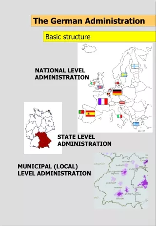
The German Administration Basic structure NATIONAL LEVEL ADMINISTRATION STATE LEVEL ADMINISTRATION MUNICIPAL (LOCAL) LEVEL ADMINISTRATION
The State Level Administration A three tier system The highest level: State ministries The medium level: District (regional) government The lower level: Taluka (county) The state is not represented at the municipal (local) level, only larger cities may performing simultaneously taluka functions
The German Administration Basic principles The vertical linkages between national, state and local level are guiding, not directing links • the national level does not dictate state level planning, • the state level does not dictate local level planning
Planning in Germany Basic principle Plan preparation and implementation is not governed by standards but by result open planning procedures. • Consequences: • site and situation specific solutions • democratic accepted solutions • optimal solution under given circumstances
The German Administration Principles of plan co-ordination • All new plans are developed in direct collaboration and interaction with all concerned authorities • Plan contents of relevance for other plans is incorporated into those plans (a water protection zone is formally incorporated into other plans such as a master plan) • Overall plan co-ordination is executed at local, regional and state spatial planning levels
The German Administration Principles of plan co-ordination “Counter Current Principle” State level coordinative planning (Bavarian Ministry of Regional Development and Environmental Affairs) State level sectoral planning (Bavarian State Office of Environmental Protection) State level sectoral planning (for inst. Bavarian State Office of Water Management) Regional level coordinative planning Regional level sectoral planning (like Water Resource Management of Central Franconia) Regional level sectoral planning (for inst. Environmental Protection Authority) Local level coordinative planning (Municipality) Local level sectoral planning (Local Nature Conservation Office) Local level sectoral planning (Environmental Protection Department)
The German Administration Principles in decision making and execution Decision-making as well as execution is usually the task of the lowest possible level within the administrative hierarchy. • Examples: • Licensing and control of industries: taluka or even city level • Approval of local master plans: taluka level; for cities: district level • Notification of water protection zones: taluka level
The German Administration Tools for plan co-ordination • Prescribed co-ordination procedures and • required degree of mutual collaboration: • by exchange of information • by mutual collaboration • by mutual consent • informational notification: plan contents of relevance for other plans are incorporated into them
Spatial Environmental Planning in Germany Driving force behind its success • Based on demand for land plans: • Identify suitable sites for all kind of development activities based on environmental considerations • Secure the sites by including them into spatial plans • Offer much more sites than are actually needed by all prospective users
Why Spatial Planning ? The instrument for resource management and environmental protection
Spatial Planning Basic Objectives Ecological compatible Land Use Planning and Management
Spatial Planning Strategic approach Ecological compatible Land Use Planning and Management
Tools in Ecological Compatible Land Use Management Information Management Instruments • Spatial resource assessments • A spatial resource assessment is a spatial evaluation of a specific natural resource (e.g. groundwater resources) in terms of: • Availability and quantity • Quality • Susceptibility or sensitivity with respect to resource degradation caused by human activities (e.g. land use) • Spatial resource assessments are usually presented in form of maps • Comprehensive spatial suitability and sensitivity assessments • They are: • prepared not for single resources but for all natural resources of a defined planning area • in form of an atlas. An example are the thematic resource maps of the Zoning Atlas.
Tools in Ecological Compatible Land Use Management Spatial Planning Instruments • Development programmes Development programmes are prepared at State level. They define development objectives and a framework for the application of instruments to achieve this objectives. Central Places, development axes, economical weak areas and urban agglomerations are defined. • Land use plans Land use plans designate and allot different types of land uses (zones) for a given planning area, normally a local administrative body (municipalities, cities). A land use plan may cover the whole planning area or parts of it. A land use plan is normally legally binding. • Regional plans Regional plans are usually prepared for larger spatial units such as districts. They provide land use regulations based on a regional development perspective. A regional plan provides guidelines for development of Master Plans at the lower planning level.
Tools in Ecological Compatible Land Use Management Spatial Planning Instruments • Preferential areas Preferential areas are areas designated to a predominant use or function such as agricultural use, forestry, or recreation. The dominant use or function should not be adversely affected by other uses. Thus non-disturbing other uses may be allowed or restricted in such areas. Such plans may be not legally binding but provide a guidance for other plans. An example is the final industrial zoning map in the Zoning Atlas. • Protection areas Protection areas are areas which provide important natural functions (e.g. wildlife; groundwater for public supply systems etc.) and which are sensitive or susceptible to disturbances from other uses. They have thus to be protected by strict use regulations allowing only few non-disturbing uses. Such plans are normally legally binding. • Landscape development concepts and plans Landscape development concepts and plans are usually prepared for a given planning area covering all environmental or ecological aspects in terms of spatial rehabilitation, protection and development objectives. They include regulations needed for plan implementation. Such plans may have recommendatory or legal status.
Tools in Ecological Compatible Land Use Management Co-ordination Instruments • “Informational Notification” ”Informational Notification” means that authorities co-ordinate their spatial preferential or protection areas in such a way that those designated areas are incorporated into the plans of other authorities. For example water protection areas which may be declared by the Groundwater Board (e.g. in Maharashtra) may be shown in the Zoning Atlas while zones from this Atlas might be incorporated into the plans of the Groundwater Board. In this way a spatial co-ordination of the planning objectives of different planning authorities might be ensured.
The hierarchy of spatial plans Spatial Planning in Germany Federal level Overall competence Basic ideas, principles Federal Regional Planning Act, Guidelines for Regional Planning Building code, zoning ordinance State level Principles and objectives for the State development e.g. central locations, development axes, area categories, suitability areas Regional planning acts, regional policy and development programmes and plans State level building codes Specifications Examination Approval Potentials/objectives of the regions Agreement with sectoral plans and landscape planning Planning regions framework planning for the regions (districts) specified objectives for regional development Specifications Examination Potentials/objectives of the communes/municipalities Municipalities/Communes Communal development planning and communal master planning master plans: binding for the administration layout plans: legally binding for everybody Specifications Agreement Approval Objectives/projects Private and public projects Planning of concrete construction projects (building plan) and performance of the building
The planning hierarchy Spatial Planning in Germany