Download
1 / 12
120 likes | 141 Vues
This land surface paper by Douglas Clark and Christopher Taylor from the Centre for Ecology and Hydrology, Wallingford provides an overview of work in progress on the HiGEM model. The paper delves into the impact of precipitation, temperature, radiation, snow extent, river flow, and soil moisture stress on the HiGEM model, comparing it with Earth observation data and highlighting biases in different regions. The researchers emphasize the need to develop new aspects for publication, focusing on key regions and catchments. The analysis covers annual average precipitation and temperature on land, with insights into wet and dry biases in regions such as the USA, Brazil, Indonesia, and Africa. Additionally, the study evaluates river flow in major catchments, highlighting model deficiencies and suggesting improvements for better accuracy. The paper also addresses challenges with snow extent and high-latitude river flow modeling. Overall, the research aims to enhance understanding of the HiGEM model and its performance in simulating land surface processes.

E N D
HiGEM land surface paper Douglas Clark Christopher Taylor Centre for Ecology and Hydrology, Wallingford
Progress Contribution to HiGEM overview paper Work in progress Finish in first 2 weeks Feb Land surface paper Still at an early stage
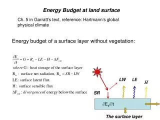
Outline of land surface paper Description of climate over land Look at “drivers” of the land model – precip, T, radiation. Snow extent in coupled and uncoupled runs River flow in coupled and uncoupled runs Soil moisture stress in coupled and uncoupled runs Compare with EO product. Can we relate biases in different fields? Focus on key regions/catchments What’s the story? Need to emphasise/develop new aspects – if we want to get published!
Precipitation and temperature (on land) Annual averages Precipitation (mm d-1) HiGEM has smaller wet bias – all seasons, global and tropics. >50N not much difference HiGEM-HadGEM, wet bias slightly worse in HiGEM. Temperature (K) HiGEM has smaller cool bias – all seasons, global and tropics. >50N smaller cool bias, except JJA now has larger warm bias.
Precipitation (on land) Wet bias, worse in HiGEM: USA, Brazilian highlands, Uruguay Wet bias, better in HiGEM: Indonesia, Siberia, southern Africa, central S.America, SW. Europe, E.China Dry bias, worse in HiGEM: W.Africa
Precipitation 50 major catchments with (relatively) long-term riverflow data. Exclude those with most obvious flow regulation/abstraction – e.g. Parana.
Brahmaputra Irrawaddy Amazon Yangtze Xi Jiang Columbia Murray Senegal Ganges Precipitation
HiGEM better. Offline poor. GCMs poor. Offline better. GCM volumes good, but too late. GCMs too wet in all of these. Poor offline suggests model deficiencies. River flow – the four largest catchments
Yangtze Ganges Anadyr Khatanga Orinoco River flow Too much E? Offline far from perfect!
River flow – high latitudes Slightly too little flow, too late. Offline timing better with “old soil”. Issues include: Infiltration into partially frozen soil. Simple runoff model.
Moisture stress Richard Ellis et al.
Snow extent HiGEM HadGEM Offline (1deg) GCMs – wet bias (small & difficulty with obs) and cold bias.