Download
1 / 43
490 likes | 861 Vues
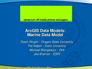
Marine GIS Data Model Example data problems for marine analysis. P.N. Halpin E.A. Treml Nicholas School of the Environment And Earth Sciences Duke University. Marine GIS Data Model . Georelational model. Geodatabase model . Halpin & Treml 2002.

E N D
Marine GIS Data ModelExample data problems for marine analysis P.N. Halpin E.A. Treml Nicholas School of the Environment And Earth Sciences Duke University
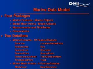
Marine GIS Data Model Georelational model Geodatabase model Halpin & Treml 2002
Marine GIS Data Model sampling • Marine data is collected through a wide range of: • Methods • Instruments • Time scales • Periodicity • Precision • Accuracy Halpin & Treml 2002
Marine GIS Data Model • Marine GIS Applications are especially complex due to… • Wide array of sampling media • Data types • Data dependencies* (e.g. time, effort…) Halpin & Treml 2002
Marine GIS Data Model Recently a team got together to begin the development of a standard marine data model… The central issue: How do we do a better job of analyzing a 4 dimensional marine world with 2.5D GIS software… Halpin & Treml 2002
Marine GIS Data Model Process Halpin & Treml 2002
Marine GIS Data Model Halpin & Treml 2002
Marine GIS Data Model Georelational model Geodatabase model Halpin & Treml 2002
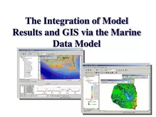
Marine GIS Data Model An extension of GIS features to better fit marine applications… This is a conceptual diagram… How implement this is open for discussion… Halpin & Treml 2002
Marine GIS Data Model Example Goal: To begin with example data that fills as many different data types as possible. Halpin & Treml 2002
Marine GIS Data Model Example Gulf of Maine Selected due to rich history of data collection across a wide range of marine science and management disciplines. Halpin & Treml 2002
Gulf of Maine: Sounding and Elevation Data National Ocean Service (NOS) Hydrographic Data Base Shiptrack bathymetry data (GLOBEC) Grid bathymetry data (GLOBEC) http://pubs.usgs.gov/openfile/of98-801/bathy/data.htm Halpin & Treml 2002
Gulf of Maine: Bathymetry GRIDS & Contours 15 arc-sec bathymetry rasters 100m contours vector http://pubs.usgs.gov/openfile/of98-801/bathy/data.htm Halpin & Treml 2002
Gulf of Maine Dynamic hydrographic circulation models Streamfunction Finite Element Model Model TIN nodes Dartmouth College, Hanover, New Hampshire, U.S.A. http://www-nml.dartmouth.edu/circmods/gom.html Halpin & Treml 2002
Gulf of Maine Dynamic hydrographic circulation models Drifter tracking simulation Dartmouth College, Hanover, New Hampshire, U.S.A. http://www-nml.dartmouth.edu/circmods/gom.html Halpin & Treml 2002
Gulf of Maine SST Gradients & Fronts Synoptic data collection of SST (SeaWiFs-AVHRR) processed to develop gradient and distance to front raster data sets. SST Fronts Distance from SST fronts (surface) Halpin & Treml 2002
Gulf of Maine Fisheries survey data Ground fish stocks Halpin & Treml 2002
4 1 2 3 Marine GIS Data Model Example Goal: To begin with example data that fills as many different data types as possible. Halpin & Treml 2002
Gulf of Maine Fixed X,Y,Z Data NMS/NOAA Baseline Point Data Offshore boundaries Data source: USGS-NOAA Halpin & Treml 2002
Gulf of Maine Fixed X,Y,Z Data NOS Bathymetric Point Data Data source: USGS-NOS Halpin & Treml 2002
Gulf of Maine Cruise Survey Observation Data Harbor Porpoise (Fall 1999). Data source: Debi Palka, NMFS Halpin & Treml 2002
Gulf of Maine Cruise Survey Observation Data 1) SPP all species are harbor porpoises 2) strata. This could be: high density (high), intermediate density (interm), inshore, offshore, and extra. 3) team. This can be either upper or lower. Some of the groups of porpoises were seen by only the upper team, others by only the lower team, and some were seen by both teams. All sightings are included no matter what its duplicate status. 4) year, month, day. Data source: Debi Palka, NMFS Halpin & Treml 2002
Gulf of Maine Cruise Survey Observation Data 5) transect. This is a straight piece of effort, which could be made of several legs. 6) leg. This is part of a transect where everything is the same, ie. observer placement, weather. 7) obsnum. This is a unique sighting number for an animal group seen by a team on a particular day. 8) sighttype. This can be either “O” for original or “F” for follow-on sighting. That is “O” is the first time that group was seen and “F” is the same group but a later surfacing. So for a group that had two recorded surfacing, the obsnum is the same but the first has sighttype=”O” and the second has sighttype=”F”. Data source: Debi Palka, NMFS Halpin & Treml 2002
Gulf of Maine Cruise Survey Observation Data 10) sizeb. This is the best estimate for the size of the group. 11) raddist. This is the estimate of the distance (in meter) between the ship and the group. 12) angle. This is the estimate of the angle between the track line (0 degrees) and line of sight to the group. 90 degrees is 90 degrees to the starboard, 270 degrees is 90 degrees to the port. 13) swmdir. Estimated direction the group was swimming at the time of the recording. Use same compass angles as in 12) angle. Data source: Debi Palka, NMFS Halpin & Treml 2002
Gulf of Maine Cruise Survey Observation Data 14) sightlat and sightlong. Position of the ship at the time of the sighting. NOT the exact position of the group. Format is degree.fraction of a degree. For example, 43 degrees 30 minutes is 40.50. 15) beaufort. Beaufort sea state. Not necessarily the wind speed. Format is the normal beaufort sea state (usually an integer) and an estimation of the percentage between the integer beaufort sea states. So beaufort 2.9 is almost a beaufort 3 but not quite. 16) shipspeed. Ship’s speed through the water. 17) smg. “Speed made good” over the ground. Data source: Debi Palka, NMFS Halpin & Treml 2002
Gulf of Maine Recording Buoys Hydrodynamic Data Data source: Halpin & Treml 2002
Gulf of Maine Recording Buoys Selected Buoy data attributes (1978 to present): Wind Direction (WDIR): measured ever 10 minutes 24hours a day Wind Speed (WSPD): measured ever 10 minutes 24hours aday Wind Gust (GST): measured every hour 24hours a day Wave Height (WVHT): measured every hour 24hours a day Dominant Wave Period (DPD): measured every hour 24hours a day Atmospheric Pressure (PRES): measured every hour 24hours a day Pressure Tendency (PTDY): measured every hour 24hours a day Water Temperature (WTMP): measured every hour 24hours a day Note: for standard meteorological data, there are approximately 200k measurements since 1978, approximately 2400 for the duration of this marine mammal study. Data source: http://www.ndbc.noaa.gov/station_history.phtml?station=44005 Halpin & Treml 2002
Gulf of Maine Harbor Porpoise Telemetry Data 5 animals tracked as point observations over time (Fall 1999). Data source: Tara Cox, Duke University Halpin & Treml 2002
Gulf of Maine Shoreline Shoreline Vector Data NOAA Medium Resolution Shoreline . Data source: NOAA Halpin & Treml 2002
Gulf of Maine Bathymetry Research cruise route* Data source: Anonymous Halpin & Treml 2002
Gulf of Maine Prey (Silver Hake < 40cm) Trawl Data Silver Hake < 40cm (Fall 1999). Data source: Tara Cox, Duke University Halpin & Treml 2002
Gulf of Maine Prey (Silver Hake < 40cm) Trawl Data: Silver Hake < 40cm (Fall 1999). Example: Time-duration vector Data source: Tara Cox, Duke University Halpin & Treml 2002
Gulf of Maine Cruise Survey Effort Data Time duration effort (Fall 1999). Data source: Debi Palka, NEFMS Data source: Debi Palka, NMFS Halpin & Treml 2002
Gulf of Maine Cruise Survey Time duration effort data (Fall 1999). Same as in sighting data for variables strata, year, month, day, transect, leg, and beaufort. 1) begtime, endtime. Time the leg began and ended. Format same as sighttime above. 2) beglat, beglong. Corresponding latitude and longitude for the time the leg began. Format same as sightlat above. 3) endlat,endlong. Corresponding latitude and longitude for the time the leg ended. Data source: Debi Palka, NMFS Halpin & Treml 2002
Gulf of Maine SBNMS Boundary Boundary / Area Data Stelwagen Bank (SBNMS) Data source: NOAA Halpin & Treml 2002
Gulf of Maine Time-Area Closures Time-area Data Data source: Halpin & Treml 2002
Gulf of Maine Bathymetry Depth Data 15 minute bathymetry raster grid . Data source: Halpin & Treml 2002
Gulf of Maine Distance from Fronts SST / Front / Distance Data Raster Data Model? ? Data source: Rob Schick NEA http://marinegis.org Halpin & Treml 2002
Marine GIS Data Model Example Data and the current data model: The existing data model defines a generic, conceptually designed framework. This current structure requires extensive manipulation / customization to allow for the incorporation of “real” data. Halpin & Treml 2002
Marine GIS Data Model Example Data Questions: What types of data are missing? Should be included? What relationships should be included? What should be optional vs. required? Halpin & Treml 2002
Marine GIS Data Model Questions for Discussion: Should temporal components be treated as optional attributes within a geodatabase or as required variables of new “features classes”? Should there be a more generic dynamic / temporal dependent feature class extensions (useful to marine, atmospheric, hydrologic… disciplines?). Should there be a single “marine data model” or more field specific models: benthic mapping, navigation, pelagic-animal tracking, oceanographic, bottom mapping…? Halpin & Treml 2002