Download
1 / 2
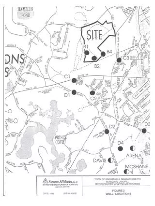
Groundwater Contour Map and Monitoring Wells – August 2001
20 likes | 169 Vues
This document presents the groundwater contour map from August 2001, detailing the distribution and levels of groundwater in the study area. Accompanying the map are the locations of groundwater monitoring wells, which play a crucial role in tracking changes in groundwater levels over time. The data is essential for understanding groundwater availability, assessing potential contamination risks, and formulating water resource management strategies. Significant changes in groundwater trends can inform future research and environmental planning.
Télécharger la présentation 
Groundwater Contour Map and Monitoring Wells – August 2001
An Image/Link below is provided (as is) to download presentation
Download Policy: Content on the Website is provided to you AS IS for your information and personal use and may not be sold / licensed / shared on other websites without getting consent from its author.
Content is provided to you AS IS for your information and personal use only.
Download presentation by click this link.
While downloading, if for some reason you are not able to download a presentation, the publisher may have deleted the file from their server.
During download, if you can't get a presentation, the file might be deleted by the publisher.
E N D


More Related