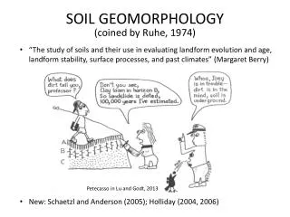
Soil Geomorphology and Soilscapes
440 likes | 703 Vues
Soil Geomorphology and Soilscapes. Overview and Introduction. Participant Objectives. Know and define fundamental soil geomorphic terms (e.g., landform, landscape). Apply process geomorphology to landform recognition. Interpret landforms via surface form, stratigraphy, and hydrology.

Soil Geomorphology and Soilscapes
E N D
Presentation Transcript
Soil GeomorphologyandSoilscapes Overview and Introduction
Participant Objectives • Know and define fundamental soil geomorphic terms (e.g., landform, landscape). • Apply process geomorphology to landform recognition. • Interpret landforms via surface form, stratigraphy, and hydrology. • Discern soilscape context: Geomorphic stratigraphic, hydrologic, and pedologic setting.
Soil Landscape Context • Geomorphic setting: landscape, landform, hillslope, micro feature. • Stratigraphy: Parent material sequence and composition. • Hydrology: Internal water source, flow direction, flow type, and surface outlets • Pedology: Soil horizons and their relationship to the above components.
Soil Geomorphology • The systematic description, analysis, and understanding of soil landscapes (soilscape) and near-surface materials. This includes constituent landforms, landscapes (landform assemblages), soils, parent materials and the processes that create and change them.
Landscape • A group of spatially associated landforms. • A landform collection or assemblage. • A landscape often contains landforms and soils that differ in age and formation process.
Mountain slope Outwash Terrace End Moraine Landscape: Glaciated Mountains Wysocki 2005 CO
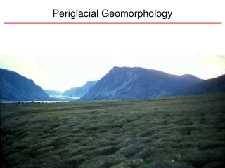
Landform Any physical earth-surface feature having an observable shape (form) and internal composition (materials and arrangement) produced by natural forces; a discrete individual. • Surface form • Internal structure -- stratigraphy • Internal hydrology or water flow
Mt Hood Oregon Composite Volcano Wysocki
Mt Katahdin ME Kettle Lake Wysocki
A field scientist must understand processes that create and change landforms and soils. One can observes features (landforms, soils, sediment bodies), but must infer process.
Soil Survey and Geomorphology Lake terraces Wave-curt terraces We observe or infer field relationships among landforms, stratigraphy, and soils.
One must understand the processes that create or control soil, landform, and sediment formation. • Think in terms of process. • How did the landform, soil, and sediment originate? • When did the landform, soil, or sediment originate?
Surface Form Size Shape Orientation Location Stratigraphy Composition What is this landform?
Landform Recognition Surface Form (topography) Stratigraphy (internal composition) Hydrology (water flow in and through landscapes)
Relict Glacial Delta Topset-foreset contact marks water plane elevation of former sea or lake level. Foresets Topsets Bottomsets Nova Scotia DNR Five Islands, Nova Scotia
What is this landform? Shape? Composition?
Red = Fine loamy till Green = Sandy or coarse loamy outwash or till Blue = Saprists or hemists
What is the stratigraphy? What is the sorting? What is the bedding? Delta County MI Wysocki
Red = Fine loamy till Green = Sandy or coarse loamy outwash or till Blue = Saprists or Hemists
Drumlin And Interdrumlin
Soil Survey and Geomorphology Soil Taxonomy and Soil Mapping • Taxonomy classifies soils based upon their properties. You must observe, measure, or infer properties to classify a soil. • Soil Taxonomy is not a predictive tool for soil mapping or a conceptual model for understanding soil-landscape relationships.
Where is it on the landscape? Soil Taxonomy Very-fine, smectitic, thermic Chromic Epiaquert What is the formation process? How does ST help you draw a polygon? Wysocki 1999
Soil Survey and Geomorphology Soil Taxonomy Bias • ST classifies and places focus on the pedon (small, laterally constrained ~ 1 meter soil area), which is not a soil landscape unit. • Uses an artificial soil depth limit (2 meters). • De-emphasizes parent material (stratigraphy)
Sharkey Holocene clayey alluvium Vertical accretion Yazoo Basin Flood Plain Meander Belt Backswamp Rolling Fork, MS Wysocki
Victoria (bowl); (chimney); Sodic Haplusterts Beaumont Formation; Late Pleistocene surface Wysocki
Flood plain clayey deltaic and marine sediments on interstream divide
Landform Recognition Surface Form (topography) Stratigraphy (internal composition) Hydrology (water flow in and through landscapes)
What and where is this soilscape? Closed depressions Glacial landscape Glacial till Water Flow direction discharge recharge
Soil Survey and Geomorphology Soil Survey (Soil Mapping – Landscape Models) • Sediment Distribution - parent materials • Soil-Landform Relationships - geomorphic processes • Age - geomorphic surfaces Soil Map Unit Design Soil Map Unit Description
Late Sangamon Pediment Wisconsin age erosion surface Adair Soil Shelby Soil
Soil Survey and Geomorphology Soils are mapped largely by what can be seen: Landforms, vegetation, topography, slope inflections, rocks – and the known or inferred relationships that these features have with soil patterns, including parent materials, drainage (hydrology), and land surface age.
Mountain slope End Moraine Outwash Terrace Soil 4 backslope Soil 3 shoulder Soil 5 alluvium Soil 2 outwash Soil 6 outwash Soil 1 till Landscape: Glaciated Mountains Wysocki 2005 CO
Soilscape Context • Geomorphic setting: landscape, landform, hillslope, micro feature. • Stratigraphy: Parent material sequence and composition. • Hydrology: Internal water source, flow direction, flow type, and surface outlets • Pedology: Soil horizons and their relationship to the above components.