Geography Handbook
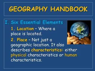
Geography Handbook. Introduction Pages: 4-15. How Do I Use Maps and Globes?. Hemispheres. Areas that are designated by imaginary lines that crisscross the globe. Geographers use these lines to pinpoint a specific location. Equator. (One of the imaginary lines)

Geography Handbook
E N D
Presentation Transcript
Geography Handbook Introduction Pages: 4-15
Hemispheres • Areas that are designated by imaginary lines that crisscross the globe. • Geographers use these lines to pinpoint a specific location.
Equator • (One of the imaginary lines) • Circles the middle of the Earth • It divides the Earth into Northern and Southern Hemispheres.
Prime Meridian • (one of the imaginary lines) • Vertically divides the Earth into Eastern and Western Hemispheres.
Latitude • Lines that circle the earth parallel to the equator. • Horizontal
Longitude • Circle the earth from pole to pole. • Vertical
Absolute Location • The precise spot where one line of longitude crosses one line of latitude.
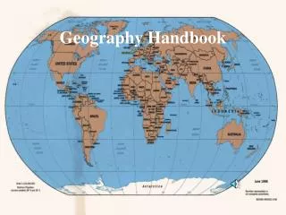
Maps to Globes • Maps have limitations • Imagine drawing a round object on a flat surface • However, maps are easier to see.
Parts of Map • Map Key- Explains the lines, symbols, and colors used on a map. • Scale Bar- A measuring line that helps you figure out distances on a map. • Compass Rose- Tells you the cardinal directions- north, south, east, west
Physical Maps • Display landforms and water features
Political Maps • Show the names and boundaries of a country
Contour Maps • Physical map that also shows elevation.
Special Purpose Maps • Present specific kinds of information
Graphs • A way of summarizing and presenting information visually.
Bar Graph • Graphs that use bars or wide lines to compare data.
Line Graph • Shows changes over a period of time
Circle Graph • Demonstrate how the whole of something is divided • EX: World Population
Geographic Dictionary and Photograph Pages 14-15