Intelligent Navigation Payload for Autonomous Urban Reconnaissance Missions
220 likes | 351 Vues
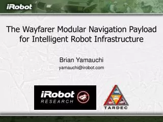
The Wayfarer Modular Navigation Payload is designed for small Unmanned Ground Vehicles (UGVs) to perform autonomous reconnaissance missions in urban environments. By leveraging advanced sensors like 360-degree LADAR, stereo vision systems, and thermal imaging, the UGVs autonomously navigate urban streets, record digital video, and build maps. This initiative addresses critical army needs, aiming to reduce daily casualties during patrols by minimizing the risks from hazards like snipers and explosives. The payload facilitates perimeter and route recon, ensuring safe monitoring while enhancing communication efficiency.

Intelligent Navigation Payload for Autonomous Urban Reconnaissance Missions
E N D
Presentation Transcript
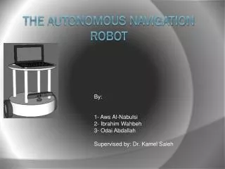
The Wayfarer Modular Navigation Payload for Intelligent Robot Infrastructure Brian Yamauchi yamauchi@irobot.com
Autonomous Urban Recon • Critical Army need • Daily casualties during patrols • Hazards • Snipers • Improvised explosive devices • RPGs • Teleop is not enough • Limited comms range • Line-of-sight restrictions • Limited bandwidth
Modular Navigation Infrastructure PackBot ► FCS SUGV ▼ Wayfarer Modular Navigation Payload ◄ R-Gator
Wayfarer Objectives • Focused, applied research project • Develop technology to enable small UGVs to perform autonomous recon missions • Enable small UGVs to: • Navigate autonomously down urban streets • Record digital video (EO/IR) and build map • Return autonomously to starting point • Provide video log and map to warfighters
Urban Reconnaissance Missions • Perimeter Recon • Follow outside wall of building • Route Recon • Follow current street for specified distance • Street Recon • Follow GPS waypoints and street directions • Record EO/IR video and build map • Return to starting point
Wayfarer Sensors • SICK LD OEM 360-degree planar LADAR • Point Grey Bumblebee stereo vision system • Organic GPS receiver • Crossbow six-axis IMU • Color and low-light B/W video cameras • Indigo Omega FLIR camera • Swiss Ranger 3D flash LADAR
Scaled Vector Field Histogram (SVFH) • Extension of Borenstein & Koren’s Vector Field Histogram (VFH) obstacle avoidance • VFH: Map each range reading from sensors to corresponding polar coordinate sector • SVFH: Spread each reading to vote for all sectors within an arc length inversely proportional to range: q = k / r q: arc length (radians), k: constant (0.4), r: range (meters)
SVFH Hallway Example SVFH Bins Clear Vectors
SVFH Intersection Example SVFH Bins Clear Vectors
Perimeter Following • Detect and follow building walls • Hough Transform • Detects linear features in range data • Finds building walls and other street-aligned features (e.g. cars, curbs) • Collects votes to determine current wall heading • Integrated with obstacle avoidance
Hallway Wall Detection All Lines Best Line
Intersection Wall Detection All Lines Best Line
Outdoor Perimeter Detection Wall Tracking Landscape Tracking
Autonomous Mapping • Build occupancy grid map on robot • Transmit local region back to OCU to minimize bandwidth usage • Runs in parallel with navigation and avoidance • Robot can travel beyond communications range and return with a map • Can also run in background during teleoperation
Localization • Heading tracking using Hough transform • Track orientation of linear features • Use to estimate robot orientation • Alternative approaches • Scan matching • GPS/Compass/INS • Kalman filters • Particle filters (Monte Carlo SLAM)
Future Work • Outdoor testing of perimeter following • Street following • GPS-based street navigation
Conclusions • Wayfarer will provide autonomous urban navigation technology for man-portable UGVs • By September 2005, we will have two fully-operational Wayfarer UGV prototypes able to perform urban reconnaissance missions • Wayfarer navigation payload will provide intelligent navigation infrastructure for PackBots and R-Gators, as well as FCS SUGV and other UGVs