
Geospatial Data Distribution
E N D
Presentation Transcript
Who We Are • APFO is the primary source of aerial imagery for the U.S. Department of Agriculture. • Data Stewards for NAIP, and historical aerial photography collected for USDA dating back to 1955.
Who We Support • USDA • FSA - Compliance and Ortho Imagery • NRCS – Conservation • USFS – Resource Management • Federal, State and Local Governments • Land Management Agencies • Emergency Management and Response • Commercial • Planning • Litigation • Environmental • Development
How we support • Provide data warehousing and archive capabilities for USDA. • Support the implementation and use of GIS in service Centers by acquiring imagery and delivering in a format that is ready to use. • Provide contracting services to acquire geospatial data sets.
Data Acquisition and Integration • USDA acquires and integrates data sets for one purpose. • To support access and delivery of these data sets for use in meeting the agencies program mission.
Data distribution is • A means to quickly and efficiently deliver data to our customers • Accomplished thru: • Media delivery (CD, DVD, Portable Hard Drive) • Web based applications and services • FTP • APFO Sales Department
Distribution Technologies • Geospatial Data Warehouse • Accurate basemaps for the USDA • ArcIMS web services • APFO Data Provisioning System • Sales Order Processing • Ad-Hoc on demand products • Geospatial Data Gateway • Pre defined products; CCM’s and CLU’s • Geospatial One-Stop • Searchable Metadata • Access to ArcIMS web services
Business Processes • Flight Planning • NAIP Contract • Receive and archive Products • Product Inspection Process • Products released for distribution • Archive NAIP Products to GDW • Catalog NAIP Products to APFO DPS • Load 1 meter Products in SDE
Data Access and Delivery • Access and delivery of geospatial data to service center offices, internal, and external customers in support of business needs encompasses four major ideas: • Data warehousing • Data selection • Packaging • Delivery
Data Warehousing • USDA Implemented Geospatial Data Warehouse (GDW) as part of the Service Center Modernization Initiative. • To facilitate archive storage, data access, browsing, retrieval, and use of GIS data.
Data Selection • APFO Data Provisioning System (DPS) • Geospatial Data Gateway (GDG) • Geospatial One-Stop • Provide an intuitive web based searching method. • Users can find and select data by entering a county name, a place, or use an online mapping tool.
Packaging • APFO Data Provisioning System • Based on application needs users can specify how the image, vector, or tabular data is to be formatted or re-projected. • Create custom data sets for specific applications.
Delivery • APFO Data Provisioning System • Depending on the telecommunications capabilities and urgency of the data request, users may select ftp downloading or select to have media delivery. • Media Delivery • CD/DVD • USB hard drive • OnCoarse delivery from GDW
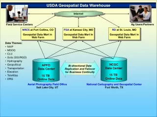
Data Management Team Recommendations • Establish on-line data warehouses at Data Acquisition and Integration Centers (APFO & NCGC). Centers serve as the certified source for data dissemination and on-line applications. Centers are responsible for acquisition, integration, storage, archival, maintenance, and dissemination of geospatial data. • Establish a common Internet Portal as a “one-stop-shopping” service for geospatial data. The distributed nature of the data appears seamless to users by linking the warehouses through a common Internet portalthat provides one-stop-shopping services.
Infrastructure • Geospatial Data Warehouse • Massive data storage architecture • More than a Petabyte capacity • Servers, storage and software to support CLU and NAIP basemapping • Data provisioning capability • On demand capability to create and deliver custom geospatial data products • Integrated large volume RIMAGE CC/DVD burners • Integrated media servers for very large image delivery • Network bandwidth and infrastructure to support the USDA requirements • Evaluation of new data management and delivery technologies
Business Requirements for the GDW: • Support Service Center Agencies • Authoritative Source for SCA Geospatial Data • MDOQ/DOQ Ortho Base imagery • NAIP Imagery • Common Land Unit • Administration and Political Boundaries & Master Reference Themes • Custom Delivery of the data • Provide Web Services for integration into desktop and web applications • Support Cost Share Partners • Volume Delivery • Support Federal Mandates • Data is in Public Domain • FGDC – Geospatial One-Stop • eGov • GOS
What the GDW Provides: • Web service access to national MDOQ and NAIP imagery for SCA offices • Support for a national CLU layer for FSA via replication of the CLU from the field service centers • APFO in-house NAIP inspection process • APFO Sales Branch data distribution via APFO Data Provisioning System
How the GDW Supports FSA Farm Programs • Base information for maintaining CLU boundaries and farm records • An intuitive base map for interacting with customers • Disaster assessment prior to and after an event • Provides authoritative data
APFO GDW Vision • Integration into the USDA delivery portal, the Geospatial Data Gateway • Expanded outreach via APFO Data Provisioning System • More sophisticated web and map services
Overview of the Data Gateway • Provides a single access point to USDA geospatial data. • Data sets served are determined by the USDA Service Center GIS strategy. • Support the development, presentation, and dissemination of information by Service Center field staff working with customers.
Goals and Objectives • The goals and objectives of access and delivery of geospatial data in the context of GIS Implementation in the Service Centers include: • Support more efficient and timely program delivery. • Supply greater quantity and variety of products and services for the customer. • Improved quality of products and services for the customer. • Optimize service center staff access to geospatial data and information.
Geospatial Data Themes • Critical Themes • Ortho imagery • NAIP Compressed County Mosaics (CCM) • MDOQ Compressed County Mosaics (CCM) • Common Land Unit (CLU)
Aerial Photography Field Office Data Provisioning System
APFO Data Provisioning System • COTS Application • Newest version (3.6) developed with APFO requirements in mind. • Is a software application designed to improve the function of “Provisioning” geospatial imagery, specifically remote sensing data-sets, to end users. • Provisioning is the process of creating custom derivative raster products from an archive of source imagery • Search for data, define your output parameters, generate the product and download the result to your application or document • Creates optimized raster datasets for use in enterprise systems such as ArcSDE/ArcIMS and ArcGIS
APFO Data Provisioning System • Provides a “view” into your data holdings • Most Current Data • Historical Archive • Catalogs • MDOQ, NAIP, CLU, others • Approximately 4-5 years of data will be on line • Integrated with the GDW infrastructure – over 1 petabyte capacity
Objectives • Establish a process to determine coverage and fulfill imagery requests for NAIP quarter quadrangle data using EarthWhere • Define integration points between imagery request fulfillment process and work order entry system (WOES) • Incorporate the APFO reference vector grids within EarthWhere • Integrate the imagery fulfillment process with the Geospatial Data Gateway
Data Access Issues • Majority FSC consumers requesting web map services • Minority FSC requests will require packaged data delivery • Special-case bulk orders for cost share partners, and large vendors • Miscellaneous small order requests for USDA users come via Gateway • Require fully automated delivery systems for Gateway-type orders • Order tracking necessary at least for Gateway-type requests
Data Delivery Methods • FTP • Media Types • CD, DVD, Portable Hard Drive • Output Directory • Symbolic links for local data access
DPS CapabilityUnder Evaluation • Raster Connect for ArcGIS • Provision directly from the DPS into ArcGIS
In Closing • APFO available to assist SCA as needed • Accounts must be requested in advance • Web based - no additional software needed • Future integrations • Large orders • Non-contiguous orders • FCGC Compliant Metadata for custom provisioned products • Funding Support • Data Storage • Data Access and Delivery